No Photo
Property Record
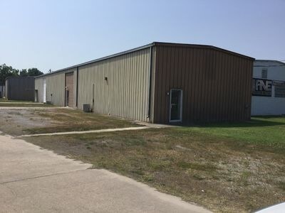
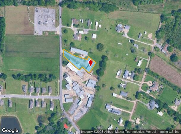
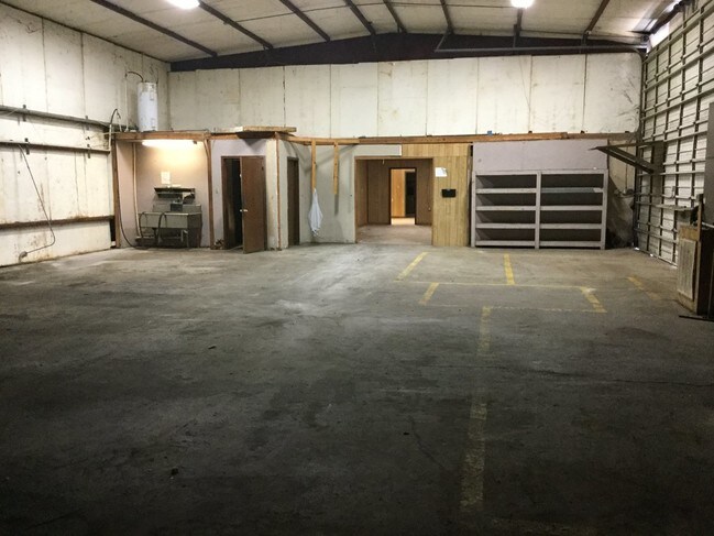
320 W Broussard Rd, Lafayette, LA 70506
NEARBY LISTINGS FOR SALE OR LEASE
-
-
View all Lafayette listings for sale on LoopNet.com
Property Detail
320 W Broussard Rd
6070863
SEC 19 T10S R4E (0.977 AC)
Warehouse
Lafayette
X
Louisiana
22055C0165J
0.98 AC
2024
Outlying Lafayette Parish
2024
Lafayette
001905
Lafayette, LA
DEMOGRAPHICS near 320 W Broussard Rd
1 mile
3 mile
5 mile
2024 Total Population
3,452
33,092
97,895
2029 Population
3,651
34,992
103,430
Pop Growth 2024-2029
+ 5.76%
+ 5.74%
+ 5.65%
Average Age
37
39
39
2024 Total Households
1,260
13,163
40,991
HH Growth 2024-2029
+ 5.87%
+ 5.77%
+ 5.72%
Median Household Inc
$81,410
$73,177
$68,167
Avg Household Size
2.60
2.40
2.30
2024 Avg HH Vehicles
2.00
2.00
2.00
Median Home Value
$245,312
$258,845
$243,349
Median Year Built
1991
1991
1989
Nearby Places
Map Layers
Map Styles
 Street
 Aerial
Transit
 Traffic
 Biking
Places
Listings with unknown addresses are not visible on the map
- Restaurants
- Banks
- Shops
- Fitness
- Groceries
PUBLIC TRANSPORTATION
COMMUTER RAIL
Lafayette Amtrak Station (Sunset Limited - Amtrak)
Drive
Walk
Distance
Lafayette Amtrak Station (Sunset Limited - Amtrak)
16 min
8.1 mi
AIRPORT
Lafayette Regional/Paul Fournet Field
Drive
Walk
Distance
Lafayette Regional/Paul Fournet Field
19 min
10.0 mi
Freight Ports
Port of Iberia
Drive
Walk
Distance
Port of Iberia
39 min
26.1 mi
SALE & LEASE HISTORY
LISTING DATE
SALE/LEASE

May 21, 2018
For Sale
May 21, 2018
For Sale
Nearby Properties
Address
Land Use
TOTAL SIZE
Lot Size
Zoning
Address
Land Use
TOTAL SIZE
Lot Size
Zoning
13,069 SF
23.27 AC
Address
Land Use
TOTAL SIZE
Lot Size
Zoning
23,377 SF
14.53 AC
Address
Land Use
TOTAL SIZE
Lot Size
Zoning
4,632 SF
14.48 AC
Address
Land Use
TOTAL SIZE
Lot Size
Zoning
7,366 SF
11.92 AC
Address
Land Use
TOTAL SIZE
Lot Size
Zoning
Address
Land Use
TOTAL SIZE
Lot Size
Zoning
27.66 AC
Address
Land Use
TOTAL SIZE
Lot Size
Zoning
Address
Land Use
TOTAL SIZE
Lot Size
Zoning
12,372 SF
10 AC
Address
Land Use
TOTAL SIZE
Lot Size
Zoning
12,291 SF
0.06 AC
Address
Land Use
TOTAL SIZE
Lot Size
Zoning
12.64 AC
Address
Land Use
TOTAL SIZE
Lot Size
Zoning
226,513 SF
22.88 AC
Address
Land Use
TOTAL SIZE
Lot Size
Zoning
173,563 SF
19.13 AC
Address
Land Use
TOTAL SIZE
Lot Size
Zoning
Address
Land Use
TOTAL SIZE
Lot Size
Zoning
11.29 AC
Address
Land Use
TOTAL SIZE
Lot Size
Zoning
Address
Land Use
TOTAL SIZE
Lot Size
Zoning
93,184 SF
10.03 AC
Address
Land Use
TOTAL SIZE
Lot Size
Zoning
134,557 SF
5.48 AC
Address
Land Use
TOTAL SIZE
Lot Size
Zoning
Address
Land Use
TOTAL SIZE
Lot Size
Zoning
146,450 SF
16.66 AC
Address
Land Use
TOTAL SIZE
Lot Size
Zoning
103,776 SF
11.54 AC
Address
Land Use
TOTAL SIZE
Lot Size
Zoning
Address
Land Use
TOTAL SIZE
Lot Size
Zoning
237,406 SF
18.61 AC
Address
Land Use
TOTAL SIZE
Lot Size
Zoning
Address
Land Use
TOTAL SIZE
Lot Size
Zoning
35,212 SF
6.58 AC
Address
Land Use
TOTAL SIZE
Lot Size
Zoning
1,613 SF
8.57 AC
Address
Land Use
TOTAL SIZE
Lot Size
Zoning
112,082 SF
11.22 AC
Address
Land Use
TOTAL SIZE
Lot Size
Zoning
107,576 SF
11.58 AC
Address
Land Use
TOTAL SIZE
Lot Size
Zoning
23.26 AC
Address
Land Use
TOTAL SIZE
Lot Size
Zoning
5,500 SF
13.57 AC
Address
Land Use
TOTAL SIZE
Lot Size
Zoning
111,693 SF
8.77 AC
The World's #1 Commercial Real Estate Marketplace
Connect with us
© 2026 CoStar Group
The information above has been obtained from sources believed reliable. While we do not doubt its accuracy we have not verified it and make no guarantee, warranty or representation about it. It is your responsibility to independently confirm its accuracy and completeness. Any projections, opinions, assumptions, or estimates used are for example only and do not represent the current or future performance of the property. The value of this transaction to you depends on tax and other factors which should be evaluated by your tax, financial, and legal advisors. You and your advisors should conduct a careful, independent investigation of the property to determine to your satisfaction the suitability of the property for your needs.