Property Record
320 W Trilby Rd, Fort Collins, CO 80525
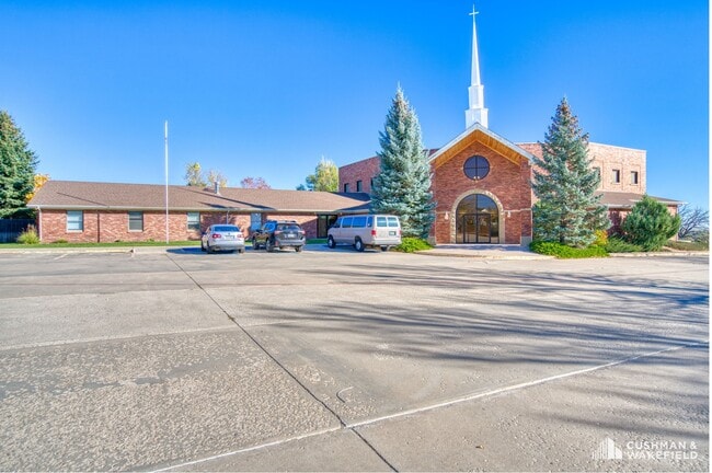

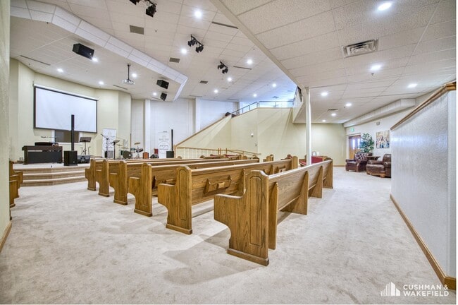
This Property Is For Sale
Property Detail
320 W Trilby Rd
96114-31-901
LOT 1, FIRST FREE WILL BAPTIST CHURCH P.D.P., FTC, (20030083024)
Religious
LARIMER
FA
Colorado
B and X Area of moderate flood hazard, usually the area between the limits of the 100-year and 500-year floods.
1
0
4.36 AC
2025
Fort Collins/Loveland
001009
Denver
9,984 SF
Fort Collins-Loveland, CO
NEARBY LISTINGS FOR SALE OR LEASE
-
-
View all Fort Collins listings for sale on LoopNet.com
DEMOGRAPHICS near 320 W Trilby Rd
1 mile
3 mile
5 mile
2025 Total Population
6,870
43,905
140,693
2030 Population
7,185
45,248
144,758
Pop Growth 2025-2030
+ 4.59%
+ 3.06%
+ 2.89%
Average Age
40
41
40
2025 Total Households
2,548
17,754
57,826
HH Growth 2025-2030
+ 4.79%
+ 3.30%
+ 3.11%
Median Household Inc
$113,392
$107,043
$93,769
Avg Household Size
2.60
2.40
2.40
2025 Avg HH Vehicles
2.00
2.00
2.00
Median Home Value
$565,482
$660,847
$599,163
Median Year Built
2001
1996
1994
Nearby Places
Map Layers
Map Styles
 Street
 Aerial
Transit
 Traffic
 Biking
Places
Listings with unknown addresses are not visible on the map
- Restaurants
- Banks
- Shops
- Fitness
- Groceries
Nearby Properties
Address
Land Use
TOTAL SIZE
Lot Size
Zoning
Address
Land Use
TOTAL SIZE
Lot Size
Zoning
222,592 SF
21.69 AC
HC
Address
Land Use
TOTAL SIZE
Lot Size
Zoning
173,575 SF
28.86 AC
RL
Address
Land Use
TOTAL SIZE
Lot Size
Zoning
1,440 SF
120.01 AC
I1
Address
Land Use
TOTAL SIZE
Lot Size
Zoning
115,260 SF
9.08 AC
HC
Address
Land Use
TOTAL SIZE
Lot Size
Zoning
222,636 SF
26.89 AC
P65
Address
Land Use
TOTAL SIZE
Lot Size
Zoning
42,205 SF
11.50 AC
Address
Land Use
TOTAL SIZE
Lot Size
Zoning
67,144 SF
39.41 AC
Address
Land Use
TOTAL SIZE
Lot Size
Zoning
109,911 SF
6.74 AC
Address
Land Use
TOTAL SIZE
Lot Size
Zoning
363,533 SF
13.39 AC
Address
Land Use
TOTAL SIZE
Lot Size
Zoning
117,157 SF
117.61 AC
Address
Land Use
TOTAL SIZE
Lot Size
Zoning
262,972 SF
15.57 AC
LMN
Address
Land Use
TOTAL SIZE
Lot Size
Zoning
93,138 SF
14.45 AC
MMN
Address
Land Use
TOTAL SIZE
Lot Size
Zoning
105,514 SF
9.55 AC
HC
Address
Land Use
TOTAL SIZE
Lot Size
Zoning
75,197 SF
6.51 AC
C
Address
Land Use
TOTAL SIZE
Lot Size
Zoning
322,880 SF
12.40 AC
HC
Address
Land Use
TOTAL SIZE
Lot Size
Zoning
61,604 SF
9.39 AC
Address
Land Use
TOTAL SIZE
Lot Size
Zoning
55,831 SF
6.69 AC
Address
Land Use
TOTAL SIZE
Lot Size
Zoning
129,570 SF
11.95 AC
HC
Address
Land Use
TOTAL SIZE
Lot Size
Zoning
193,385 SF
12.97 AC
MMN
Address
Land Use
TOTAL SIZE
Lot Size
Zoning
84,655 SF
6.39 AC
C
Address
Land Use
TOTAL SIZE
Lot Size
Zoning
100,339 SF
8.24 AC
HC
Address
Land Use
TOTAL SIZE
Lot Size
Zoning
122,650 SF
9.69 AC
C
Address
Land Use
TOTAL SIZE
Lot Size
Zoning
98,615 SF
8.68 AC
C
Address
Land Use
TOTAL SIZE
Lot Size
Zoning
74,394 SF
5.09 AC
HC
Address
Land Use
TOTAL SIZE
Lot Size
Zoning
125,250 SF
9.55 AC
P93
Address
Land Use
TOTAL SIZE
Lot Size
Zoning
106,160 SF
3.87 AC
HC
Address
Land Use
TOTAL SIZE
Lot Size
Zoning
79,313 SF
3.29 AC
HC
Address
Land Use
TOTAL SIZE
Lot Size
Zoning
107,271 SF
3.30 AC
Address
Land Use
TOTAL SIZE
Lot Size
Zoning
50,822 SF
1.19 AC
Address
Land Use
TOTAL SIZE
Lot Size
Zoning
103,352 SF
10.44 AC
HC
The World's #1 Commercial Real Estate Marketplace
Connect with us
© 2026 CoStar Group
The information above has been obtained from sources believed reliable. While we do not doubt its accuracy we have not verified it and make no guarantee, warranty or representation about it. It is your responsibility to independently confirm its accuracy and completeness. Any projections, opinions, assumptions, or estimates used are for example only and do not represent the current or future performance of the property. The value of this transaction to you depends on tax and other factors which should be evaluated by your tax, financial, and legal advisors. You and your advisors should conduct a careful, independent investigation of the property to determine to your satisfaction the suitability of the property for your needs.