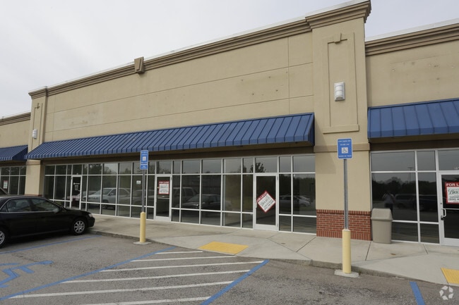
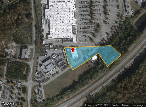
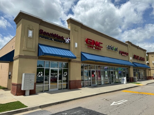
Property Record
320 Walmart Way, Eastanollee, GA 30538
NEARBY LISTINGS FOR SALE OR LEASE
Property Detail
320 Walmart Way
043-270
8223 - Primary - Sf
Wholesaleoutletdiscountstore
WAL-MART WAY TRACT A
X
Stephens
13257C0116D
Georgia
2025
2.90 AC
2025
Georgia Northeast
970302
Other Market Areas
10,773 SF
Toccoa, GA
DEMOGRAPHICS near 320 Walmart Way
1 Mile
3 Mile
5 Mile
2024 Total Population
336
9,917
19,368
2029 Population
341
10,113
19,785
Pop Growth 2024-2029
+ 1.49%
+ 1.98%
+ 2.15%
Average Age
42
42
42
2024 Total Households
133
4,042
7,726
HH Growth 2024-2029
+ 1.50%
+ 1.68%
+ 2.06%
Median Household Inc
$55,000
$48,398
$48,690
Avg Household Size
2.50
2.40
2.40
2024 Avg HH Vehicles
2.00
2.00
2.00
Median Home Value
$156,862
$146,177
$151,035
Median Year Built
1982
1979
1980
Nearby Places
Map Layers
Map Styles
 Street
 Aerial
- Restaurants
- Banks
- Shops
- Fitness
- Groceries
SALE & LEASE HISTORY
LISTING DATE
SALE/LEASE

Sep 25, 2016
For Lease
Jun 02, 2023
For Lease
Apr 19, 2017
For Lease
Nearby Properties
Address
Land Use
TOTAL SIZE
Lot Size
Zoning
Address
Land Use
TOTAL SIZE
Lot Size
Zoning
3.47 AC
CI
Address
Land Use
TOTAL SIZE
Lot Size
Zoning
218,215 SF
25.17 AC
CG
Address
Land Use
TOTAL SIZE
Lot Size
Zoning
391,121 SF
62.73 AC
CG
Address
Land Use
TOTAL SIZE
Lot Size
Zoning
52,140 SF
115.88 AC
CG
Address
Land Use
TOTAL SIZE
Lot Size
Zoning
6.56 AC
CG
Address
Land Use
TOTAL SIZE
Lot Size
Zoning
4.24 AC
M-I
Address
Land Use
TOTAL SIZE
Lot Size
Zoning
192,404 SF
27.79 AC
B-II
Address
Land Use
TOTAL SIZE
Lot Size
Zoning
Address
Land Use
TOTAL SIZE
Lot Size
Zoning
61,105 SF
64.49 AC
CG
Address
Land Use
TOTAL SIZE
Lot Size
Zoning
0.58 AC
CI
Address
Land Use
TOTAL SIZE
Lot Size
Zoning
148,256 SF
24.53 AC
CI
Address
Land Use
TOTAL SIZE
Lot Size
Zoning
68,998 SF
24.53 AC
CG
Address
Land Use
TOTAL SIZE
Lot Size
Zoning
75,274 SF
39.40 AC
CG
Address
Land Use
TOTAL SIZE
Lot Size
Zoning
23,193 SF
5.89 AC
CG
Address
Land Use
TOTAL SIZE
Lot Size
Zoning
13,568 SF
7.50 AC
B-II
Address
Land Use
TOTAL SIZE
Lot Size
Zoning
123,520 SF
25.28 AC
CI
Address
Land Use
TOTAL SIZE
Lot Size
Zoning
111,150 SF
5.91 AC
CI
Address
Land Use
TOTAL SIZE
Lot Size
Zoning
39,460 SF
8.20 AC
B-II
Address
Land Use
TOTAL SIZE
Lot Size
Zoning
110,718 SF
10.14 AC
B-II
Address
Land Use
TOTAL SIZE
Lot Size
Zoning
34,170 SF
12.91 AC
CG
Address
Land Use
TOTAL SIZE
Lot Size
Zoning
21,332 SF
147.93 AC
CI
Address
Land Use
TOTAL SIZE
Lot Size
Zoning
Address
Land Use
TOTAL SIZE
Lot Size
Zoning
32,440 SF
81.75 AC
R-IA
Address
Land Use
TOTAL SIZE
Lot Size
Zoning
11,600 SF
199.79 AC
A-I
Address
Land Use
TOTAL SIZE
Lot Size
Zoning
Address
Land Use
TOTAL SIZE
Lot Size
Zoning
167,500 SF
20.98 AC
CI
Address
Land Use
TOTAL SIZE
Lot Size
Zoning
131,717 SF
23.47 AC
CI
Address
Land Use
TOTAL SIZE
Lot Size
Zoning
74,957 SF
13.98 AC
B-II
Address
Land Use
TOTAL SIZE
Lot Size
Zoning
27,013 SF
3.25 AC
R-IA
Address
Land Use
TOTAL SIZE
Lot Size
Zoning
375 AC
LI
The World's #1 Commercial Real Estate Marketplace
Connect with us
© 2026 CoStar Group
The information above has been obtained from sources believed reliable. While we do not doubt its accuracy we have not verified it and make no guarantee, warranty or representation about it. It is your responsibility to independently confirm its accuracy and completeness. Any projections, opinions, assumptions, or estimates used are for example only and do not represent the current or future performance of the property. The value of this transaction to you depends on tax and other factors which should be evaluated by your tax, financial, and legal advisors. You and your advisors should conduct a careful, independent investigation of the property to determine to your satisfaction the suitability of the property for your needs.