Property Record
3200 W Wilshire Blvd, Oklahoma City, OK 73116


Current Lease Availabilities
NEARBY LISTINGS FOR SALE OR LEASE
Property Detail
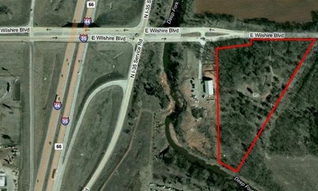
3200 W Wilshire Blvd
Oklahoma City, OK
Unpltd Pt Sec 06 12N 2W
141705500
UNPLTD PT SEC 06 12N 2W 000 000 PT NW 4 SEC 6 12N 2W BEG NE/C GOVT LOT 3 SD SEC S47.89FT TO A PT W LINE OF RR TH SWLY LEFT ON CURVE 835.37FT SW297.52FT TO CENTER LINE OF DEEP FORK CREEK TH NW175.34FT N974.84FT TO N LINE OF SD GOV LOT TH E665FT TO BEG
Residentialacreage
Oklahoma
AE
Oklahoma
40109C0190H
3
2023
9.16 AC
2024
East Oklahoma County
106608
Oklahoma City
DEMOGRAPHICS near 3200 W Wilshire Blvd
1 Mile
3 Mile
5 Mile
2024 Total Population
223
9,419
65,515
2029 Population
228
9,593
67,611
Pop Growth 2024-2029
+ 2.24%
+ 1.85%
+ 3.20%
Average Age
42
42
39
2024 Total Households
75
3,576
27,260
HH Growth 2024-2029
+ 2.67%
+ 1.90%
+ 3.36%
Median Household Inc
$114,999
$64,682
$50,587
Avg Household Size
2.80
2.50
2.30
2024 Avg HH Vehicles
3.00
2.00
2.00
Median Home Value
$450,000
$255,628
$213,563
Median Year Built
2000
1968
1971
Nearby Places
Map Layers
Map Styles
 Street
 Aerial
- Restaurants
- Banks
- Shops
- Fitness
- Groceries
PUBLIC TRANSPORTATION
COMMUTER RAIL
Oklahoma City (Heartland Flyer - Amtrak)
DRIVE
WALK
Distance
Oklahoma City (Heartland Flyer - Amtrak)
17 min
8.8 mi
AIRPORT
Will Rogers World
DRIVE
WALK
Distance
Will Rogers World
26 min
13.4 mi
Freight Ports
Tulsa Port Of Catoosa
DRIVE
WALK
Distance
Tulsa Port Of Catoosa
137 min
124.0 mi
Nearby Properties
Address
Land Use
TOTAL SIZE
Lot Size
Zoning
Address
Land Use
TOTAL SIZE
Lot Size
Zoning
819,976 SF
21.87 AC
C-3
Address
Land Use
TOTAL SIZE
Lot Size
Zoning
467,216 SF
66.90 AC
C-3
Address
Land Use
TOTAL SIZE
Lot Size
Zoning
312,308 SF
9.76 AC
C-3
Address
Land Use
TOTAL SIZE
Lot Size
Zoning
90,059 SF
14.99 AC
O-2
Address
Land Use
TOTAL SIZE
Lot Size
Zoning
294,583 SF
20.14 AC
PUD
Address
Land Use
TOTAL SIZE
Lot Size
Zoning
430,092 SF
17.35 AC
R-4
Address
Land Use
TOTAL SIZE
Lot Size
Zoning
202,147 SF
44.36 AC
PUD
Address
Land Use
TOTAL SIZE
Lot Size
Zoning
485,764 SF
6.05 AC
C-3
Address
Land Use
TOTAL SIZE
Lot Size
Zoning
452,123 SF
5.64 AC
O-2
Address
Land Use
TOTAL SIZE
Lot Size
Zoning
10,922 SF
1.04 AC
SPUD
Address
Land Use
TOTAL SIZE
Lot Size
Zoning
258,381 SF
2.54 AC
PUD
Address
Land Use
TOTAL SIZE
Lot Size
Zoning
28,099 SF
1.21 AC
O-2
Address
Land Use
TOTAL SIZE
Lot Size
Zoning
254,126 SF
2.11 AC
SPUD
Address
Land Use
TOTAL SIZE
Lot Size
Zoning
49,950 SF
3.69 AC
R-1
Address
Land Use
TOTAL SIZE
Lot Size
Zoning
21,111 SF
2.57 AC
R-4
Address
Land Use
TOTAL SIZE
Lot Size
Zoning
347,288 SF
19 AC
C-3
Address
Land Use
TOTAL SIZE
Lot Size
Zoning
34,734 SF
9.07 AC
PUD
Address
Land Use
TOTAL SIZE
Lot Size
Zoning
29,274 SF
0.93 AC
C-3
Address
Land Use
TOTAL SIZE
Lot Size
Zoning
244,699 SF
11.83 AC
C-3
Address
Land Use
TOTAL SIZE
Lot Size
Zoning
681,708 SF
20.54 AC
C-3
Address
Land Use
TOTAL SIZE
Lot Size
Zoning
436,316 SF
5.23 AC
I-1
Address
Land Use
TOTAL SIZE
Lot Size
Zoning
164,880 SF
8.95 AC
O-2
Address
Land Use
TOTAL SIZE
Lot Size
Zoning
60,238 SF
4.93 AC
PUD
Address
Land Use
TOTAL SIZE
Lot Size
Zoning
285,771 SF
8.64 AC
PUD
Address
Land Use
TOTAL SIZE
Lot Size
Zoning
69,370 SF
O-2
Address
Land Use
TOTAL SIZE
Lot Size
Zoning
1 SF
3.72 AC
C-3
Address
Land Use
TOTAL SIZE
Lot Size
Zoning
327,372 SF
14.79 AC
R-4
Address
Land Use
TOTAL SIZE
Lot Size
Zoning
167,057 SF
2.62 AC
PUD
Address
Land Use
TOTAL SIZE
Lot Size
Zoning
370,066 SF
6.83 AC
O-2
Address
Land Use
TOTAL SIZE
Lot Size
Zoning
14,720 SF
0.81 AC
C-3
The World's #1 Commercial Real Estate Marketplace
Connect with us
© 2026 CoStar Group
The information above has been obtained from sources believed reliable. While we do not doubt its accuracy we have not verified it and make no guarantee, warranty or representation about it. It is your responsibility to independently confirm its accuracy and completeness. Any projections, opinions, assumptions, or estimates used are for example only and do not represent the current or future performance of the property. The value of this transaction to you depends on tax and other factors which should be evaluated by your tax, financial, and legal advisors. You and your advisors should conduct a careful, independent investigation of the property to determine to your satisfaction the suitability of the property for your needs.