Property Record
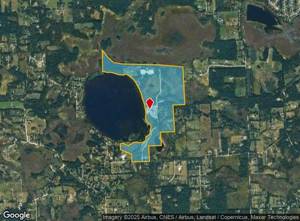
3200 Jennings Rd, Whitmore Lake, MI 48189
NEARBY LISTINGS FOR SALE OR LEASE
Property Detail
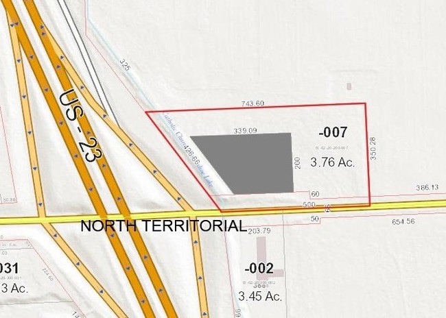
3200 Jennings Rd
03-12-200-003
OWNER REQUEST WE 12-2A BEG AT NW COR OF SEC 12, TH SWLY AT AN ANGLE OF 37 DEG 22' FROM W LINE OF SEC 486 FT, TH DEFL 10-30-00
Commercialnec
Washtenaw
X
Michigan
26161C0091E
322.05 AC
0
Washtenaw W of 23
2025
Detroit
461000
Ann Arbor, MI
DEMOGRAPHICS near 3200 Jennings Rd
1 Mile
3 Mile
5 Mile
2024 Total Population
374
11,368
26,871
2029 Population
369
11,397
27,143
Pop Growth 2024-2029
(1.34%)
+ 0.26%
+ 1.01%
Average Age
44
42
43
2024 Total Households
142
4,533
10,480
HH Growth 2024-2029
(1.41%)
+ 0.20%
+ 0.97%
Median Household Inc
$106,000
$80,586
$97,015
Avg Household Size
2.60
2.40
2.50
2024 Avg HH Vehicles
2.00
2.00
2.00
Median Home Value
$388,371
$298,116
$346,230
Median Year Built
1986
1990
1988
Nearby Places
Map Layers
Map Styles
 Street
 Aerial
- Restaurants
- Banks
- Shops
- Fitness
- Groceries
PUBLIC TRANSPORTATION
AIRPORT
Detroit Metro Wayne County
DRIVE
WALK
Distance
Detroit Metro Wayne County
53 min
37.8 mi
Freight Ports
Port of Toledo
DRIVE
WALK
Distance
Port of Toledo
95 min
70.8 mi
Nearby Properties
Address
Land Use
TOTAL SIZE
Lot Size
Zoning
Address
Land Use
TOTAL SIZE
Lot Size
Zoning
291,012 SF
70.69 AC
P.U.D
Address
Land Use
TOTAL SIZE
Lot Size
Zoning
291,012 SF
Address
Land Use
TOTAL SIZE
Lot Size
Zoning
301,472 SF
62.80 AC
LI
Address
Land Use
TOTAL SIZE
Lot Size
Zoning
893 SF
130.95 AC
MHP-MOBIL
Address
Land Use
TOTAL SIZE
Lot Size
Zoning
32,964 SF
11.95 AC
MR-MULTIPL
Address
Land Use
TOTAL SIZE
Lot Size
Zoning
10,839 SF
9.52 AC
MR-MULTIPL
Address
Land Use
TOTAL SIZE
Lot Size
Zoning
1,970 SF
37.72 AC
MHP
Address
Land Use
TOTAL SIZE
Lot Size
Zoning
103,900 SF
26.88 AC
GI
Address
Land Use
TOTAL SIZE
Lot Size
Zoning
62,548 SF
4.28 AC
GC-GEN COM
Address
Land Use
TOTAL SIZE
Lot Size
Zoning
50 AC
MHP
Address
Land Use
TOTAL SIZE
Lot Size
Zoning
70.16 AC
PSC-PLANNE
Address
Land Use
TOTAL SIZE
Lot Size
Zoning
195 AC
RAA
Address
Land Use
TOTAL SIZE
Lot Size
Zoning
46,647 SF
7.16 AC
GB
Address
Land Use
TOTAL SIZE
Lot Size
Zoning
35.74 AC
GC-GEN COM
Address
Land Use
TOTAL SIZE
Lot Size
Zoning
52,100 SF
10.36 AC
GI
Address
Land Use
TOTAL SIZE
Lot Size
Zoning
22,676 SF
5.30 AC
GC-GEN COM
Address
Land Use
TOTAL SIZE
Lot Size
Zoning
24,500 SF
12.15 AC
GI
Address
Land Use
TOTAL SIZE
Lot Size
Zoning
12,942 SF
1.52 AC
VC
Address
Land Use
TOTAL SIZE
Lot Size
Zoning
3,800 SF
5.53 AC
GC-GEN COM
Address
Land Use
TOTAL SIZE
Lot Size
Zoning
26,392 SF
13.15 AC
GI
Address
Land Use
TOTAL SIZE
Lot Size
Zoning
29,636 SF
3.51 AC
R1
Address
Land Use
TOTAL SIZE
Lot Size
Zoning
16,488 SF
10.02 AC
LI-LTD IND
Address
Land Use
TOTAL SIZE
Lot Size
Zoning
9,600 SF
10.13 AC
LI-LTD IND
Address
Land Use
TOTAL SIZE
Lot Size
Zoning
18,648 SF
19.67 AC
GI-GEN IND
Address
Land Use
TOTAL SIZE
Lot Size
Zoning
20,640 SF
10 AC
GI
Address
Land Use
TOTAL SIZE
Lot Size
Zoning
91.51 AC
LR-2AC
Address
Land Use
TOTAL SIZE
Lot Size
Zoning
8,675 SF
2.09 AC
HC
Address
Land Use
TOTAL SIZE
Lot Size
Zoning
9.69 AC
GB
Address
Land Use
TOTAL SIZE
Lot Size
Zoning
2,655 SF
3.45 AC
GC-GEN COM
Address
Land Use
TOTAL SIZE
Lot Size
Zoning
12,456 SF
1.20 AC
GB
The World's #1 Commercial Real Estate Marketplace
Connect with us
© 2025 CoStar Group
The information above has been obtained from sources believed reliable. While we do not doubt its accuracy we have not verified it and make no guarantee, warranty or representation about it. It is your responsibility to independently confirm its accuracy and completeness. Any projections, opinions, assumptions, or estimates used are for example only and do not represent the current or future performance of the property. The value of this transaction to you depends on tax and other factors which should be evaluated by your tax, financial, and legal advisors. You and your advisors should conduct a careful, independent investigation of the property to determine to your satisfaction the suitability of the property for your needs.