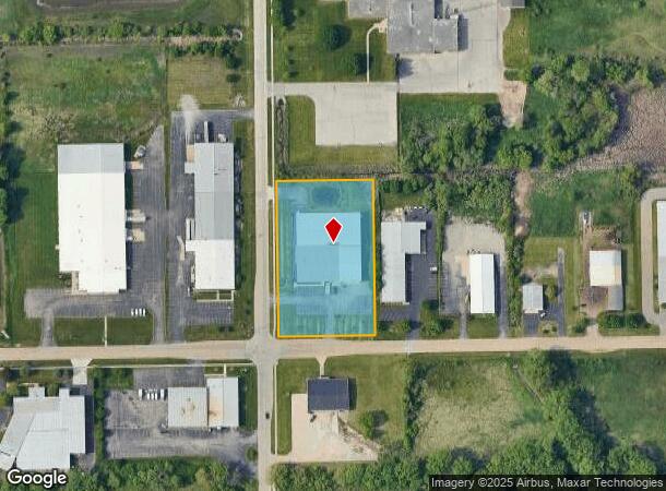
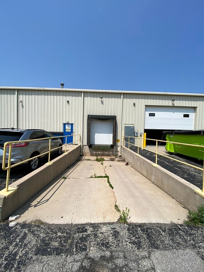
Property Record
3200 N Main St, Oshkosh, WI 54901


NEARBY LISTINGS FOR SALE OR LEASE
Property Detail
3200 N Main St
15-19602800
COM INTER N LI OF FERNAU AVE & E LI N MAIN ST N ALG SD E LI399.31 FT; N89D2519E, 250 FT S PAR TO E LI N MAIN ST 399.5FT TO N LI OF FERNAU AVE, W ALG SD N LI 250 FT TO BEG
Commercialnec
Winnebago
X
Wisconsin
55139C0220E
2.29 AC
2024
Appleton/Oshkosh
2024
Other Market Areas
001600
Oshkosh-Neenah, WI
10,800 SF
DEMOGRAPHICS near 3200 N Main St
1 Mile
3 Mile
5 Mile
2024 Total Population
5,992
38,183
71,004
2029 Population
5,945
38,215
71,268
Pop Growth 2024-2029
(0.78%)
+ 0.08%
+ 0.37%
Average Age
41
38
39
2024 Total Households
1,707
14,743
29,536
HH Growth 2024-2029
+ 0.06%
+ 0.47%
+ 0.62%
Median Household Inc
$59,047
$55,843
$58,364
Avg Household Size
2.30
2.10
2.10
2024 Avg HH Vehicles
2.00
2.00
2.00
Median Home Value
$181,946
$159,475
$168,764
Median Year Built
1982
1964
1970
Nearby Places
Map Layers
Map Styles
 Street
 Aerial
- Restaurants
- Banks
- Shops
- Fitness
- Groceries
PUBLIC TRANSPORTATION
AIRPORT
Appleton International
DRIVE
WALK
Distance
Appleton International
26 min
18.0 mi
SALE & LEASE HISTORY
LISTING DATE
SALE/LEASE

May 20, 2024
For Lease
Jul 07, 2020
For Sale
Jul 07, 2020
For Lease
Aug 21, 2024
For Sale
Nearby Properties
Address
Land Use
TOTAL SIZE
Lot Size
Zoning
Address
Land Use
TOTAL SIZE
Lot Size
Zoning
32.81 AC
CBPPD
Address
Land Use
TOTAL SIZE
Lot Size
Zoning
552,602 SF
7.28 AC
M3
Address
Land Use
TOTAL SIZE
Lot Size
Zoning
485,007 SF
41.76 AC
M3
Address
Land Use
TOTAL SIZE
Lot Size
Zoning
195,847 SF
4.66 AC
UMU-PD
Address
Land Use
TOTAL SIZE
Lot Size
Zoning
2.29 AC
RMUPDRFO
Address
Land Use
TOTAL SIZE
Lot Size
Zoning
140,184 SF
17.35 AC
MR-20-PD
Address
Land Use
TOTAL SIZE
Lot Size
Zoning
70,672 SF
4.97 AC
Address
Land Use
TOTAL SIZE
Lot Size
Zoning
70,335 SF
16 AC
HI
Address
Land Use
TOTAL SIZE
Lot Size
Zoning
2.63 AC
RMU-PD-RFO
Address
Land Use
TOTAL SIZE
Lot Size
Zoning
2.40 AC
CBP-PD
Address
Land Use
TOTAL SIZE
Lot Size
Zoning
152,505 SF
6.54 AC
MR-20-RFO
Address
Land Use
TOTAL SIZE
Lot Size
Zoning
84,363 SF
10.97 AC
C-2PD
Address
Land Use
TOTAL SIZE
Lot Size
Zoning
175,906 SF
11.60 AC
MR-20
Address
Land Use
TOTAL SIZE
Lot Size
Zoning
1.78 AC
C3
Address
Land Use
TOTAL SIZE
Lot Size
Zoning
106,340 SF
5.37 AC
MR-20
Address
Land Use
TOTAL SIZE
Lot Size
Zoning
366,482 SF
35.73 AC
M2
Address
Land Use
TOTAL SIZE
Lot Size
Zoning
4.52 AC
SMU-PD
Address
Land Use
TOTAL SIZE
Lot Size
Zoning
96,928 SF
6.94 AC
MR-12
Address
Land Use
TOTAL SIZE
Lot Size
Zoning
179,700 SF
10.06 AC
M3
Address
Land Use
TOTAL SIZE
Lot Size
Zoning
37.96 AC
Address
Land Use
TOTAL SIZE
Lot Size
Zoning
71,538 SF
7.89 AC
I-PD
Address
Land Use
TOTAL SIZE
Lot Size
Zoning
76,815 SF
12.27 AC
C2
Address
Land Use
TOTAL SIZE
Lot Size
Zoning
621,225 SF
31.97 AC
M2
Address
Land Use
TOTAL SIZE
Lot Size
Zoning
135,562 SF
9.40 AC
MR-20-PD
Address
Land Use
TOTAL SIZE
Lot Size
Zoning
71,610 SF
4.30 AC
MR-20
Address
Land Use
TOTAL SIZE
Lot Size
Zoning
24,751 SF
7.75 AC
C2
Address
Land Use
TOTAL SIZE
Lot Size
Zoning
62,266 SF
14.54 AC
HI
Address
Land Use
TOTAL SIZE
Lot Size
Zoning
14.92 AC
M1
Address
Land Use
TOTAL SIZE
Lot Size
Zoning
1.63 AC
SR2
Address
Land Use
TOTAL SIZE
Lot Size
Zoning
43,937 SF
1.97 AC
CBP-PD
The World's #1 Commercial Real Estate Marketplace
Connect with us
© 2026 CoStar Group
The information above has been obtained from sources believed reliable. While we do not doubt its accuracy we have not verified it and make no guarantee, warranty or representation about it. It is your responsibility to independently confirm its accuracy and completeness. Any projections, opinions, assumptions, or estimates used are for example only and do not represent the current or future performance of the property. The value of this transaction to you depends on tax and other factors which should be evaluated by your tax, financial, and legal advisors. You and your advisors should conduct a careful, independent investigation of the property to determine to your satisfaction the suitability of the property for your needs.