Property Record
3200 Old Stone Way Ne, Sauk Rapids, MN 56379

NEARBY LISTINGS FOR SALE OR LEASE
-
-
View all Sauk Rapids listings for sale on LoopNet.com
Property Detail
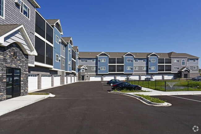
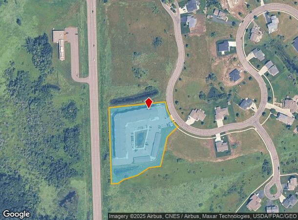
3200 Old Stone Way Ne
St. Cloud, MN
Villages Of Creek Side Plat 5
19.04869.00
SECT-07 TWP-036 RANGE-030 VILLAGES OF CREEK SIDE PLAT 5 LOT-001 BLOCK-002
Multifamilydwelling
Benton
X
Minnesota
27145C0635E
1
2025
2.89 AC
2025
Outlying Benton County
020300
Minneapolis/St Paul
DEMOGRAPHICS near 3200 Old Stone Way Ne
1 Mile
3 Mile
5 Mile
2024 Total Population
1,400
17,174
70,639
2029 Population
1,415
17,211
72,417
Pop Growth 2024-2029
+ 1.07%
+ 0.22%
+ 2.52%
Average Age
34
39
37
2024 Total Households
530
7,177
28,038
HH Growth 2024-2029
+ 0.94%
+ 0.20%
+ 2.59%
Median Household Inc
$89,035
$59,527
$55,644
Avg Household Size
2.60
2.30
2.30
2024 Avg HH Vehicles
2.00
2.00
2.00
Median Home Value
$251,590
$206,696
$187,939
Median Year Built
2005
1987
1980
Nearby Places
Map Layers
Map Styles
 Street
 Aerial
- Restaurants
- Banks
- Shops
- Fitness
- Groceries
PUBLIC TRANSPORTATION
COMMUTER RAIL
St. Cloud Amtrak Station (Empire Builder - Amtrak)
DRIVE
WALK
Distance
St. Cloud Amtrak Station (Empire Builder - Amtrak)
9 min
4.9 mi
Freight Ports
Port Milwaukee
DRIVE
WALK
Distance
Port Milwaukee
456 min
406.4 mi
Nearby Properties
Address
Land Use
TOTAL SIZE
Lot Size
Zoning
Address
Land Use
TOTAL SIZE
Lot Size
Zoning
362,000 SF
86.20 AC
Address
Land Use
TOTAL SIZE
Lot Size
Zoning
10,800 SF
24.94 AC
Address
Land Use
TOTAL SIZE
Lot Size
Zoning
Address
Land Use
TOTAL SIZE
Lot Size
Zoning
252,469 SF
35 AC
Address
Land Use
TOTAL SIZE
Lot Size
Zoning
149,778 SF
7.86 AC
Address
Land Use
TOTAL SIZE
Lot Size
Zoning
Address
Land Use
TOTAL SIZE
Lot Size
Zoning
232,274 SF
2.94 AC
R3
Address
Land Use
TOTAL SIZE
Lot Size
Zoning
127,460 SF
5 AC
Address
Land Use
TOTAL SIZE
Lot Size
Zoning
6.61 AC
Address
Land Use
TOTAL SIZE
Lot Size
Zoning
29,349 SF
4.83 AC
Address
Land Use
TOTAL SIZE
Lot Size
Zoning
71,940 SF
1.99 AC
Address
Land Use
TOTAL SIZE
Lot Size
Zoning
81,500 SF
11.01 AC
Address
Land Use
TOTAL SIZE
Lot Size
Zoning
4.21 AC
Address
Land Use
TOTAL SIZE
Lot Size
Zoning
13,217 SF
3.38 AC
Address
Land Use
TOTAL SIZE
Lot Size
Zoning
13.82 AC
Address
Land Use
TOTAL SIZE
Lot Size
Zoning
32,805 SF
18.80 AC
Address
Land Use
TOTAL SIZE
Lot Size
Zoning
61,680 SF
3.39 AC
Address
Land Use
TOTAL SIZE
Lot Size
Zoning
Address
Land Use
TOTAL SIZE
Lot Size
Zoning
Address
Land Use
TOTAL SIZE
Lot Size
Zoning
Address
Land Use
TOTAL SIZE
Lot Size
Zoning
1,205 SF
23.33 AC
Address
Land Use
TOTAL SIZE
Lot Size
Zoning
Address
Land Use
TOTAL SIZE
Lot Size
Zoning
Address
Land Use
TOTAL SIZE
Lot Size
Zoning
81,584 SF
10.86 AC
Address
Land Use
TOTAL SIZE
Lot Size
Zoning
5.97 AC
Address
Land Use
TOTAL SIZE
Lot Size
Zoning
35,777 SF
31.42 AC
Address
Land Use
TOTAL SIZE
Lot Size
Zoning
72,750 SF
8.26 AC
Address
Land Use
TOTAL SIZE
Lot Size
Zoning
248,400 SF
24.66 AC
The World's #1 Commercial Real Estate Marketplace
Connect with us
© 2026 CoStar Group
The information above has been obtained from sources believed reliable. While we do not doubt its accuracy we have not verified it and make no guarantee, warranty or representation about it. It is your responsibility to independently confirm its accuracy and completeness. Any projections, opinions, assumptions, or estimates used are for example only and do not represent the current or future performance of the property. The value of this transaction to you depends on tax and other factors which should be evaluated by your tax, financial, and legal advisors. You and your advisors should conduct a careful, independent investigation of the property to determine to your satisfaction the suitability of the property for your needs.