Property Record
3201 Macarthur Blvd, Oakland, CA 94602
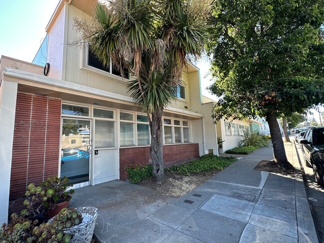


This Property Is For Sale
NEARBY LISTINGS FOR SALE OR LEASE
Property Detail
3201 Macarthur Blvd
Oakland-Fremont-Berkeley, CA
Laurel Grove Park
028-0945-023-04
LOT: 00004 BLK: 0023 AR: 0028 PAGE: 0945
Officebuilding
Alameda
X
California
06001C0087G
5
2024
0.20 AC
2025
Oakland-South/Airport
406601
East Bay/Oakland
5,457 SF
DEMOGRAPHICS near 3201 Macarthur Blvd
1 Mile
3 Mile
5 Mile
2024 Total Population
37,734
232,050
511,256
2029 Population
36,402
223,732
496,167
Pop Growth 2024-2029
(3.53%)
(3.58%)
(2.95%)
Average Age
41
40
41
2024 Total Households
14,089
83,758
196,301
HH Growth 2024-2029
(3.77%)
(3.75%)
(2.99%)
Median Household Inc
$96,082
$90,370
$95,319
Avg Household Size
2.60
2.60
2.40
2024 Avg HH Vehicles
2.00
2.00
2.00
Median Home Value
$857,227
$946,407
$985,971
Median Year Built
1947
1949
1955
Nearby Places
Map Layers
Map Styles
 Street
 Aerial
- Restaurants
- Banks
- Shops
- Fitness
- Groceries
PUBLIC TRANSPORTATION
COMMUTER RAIL
DRIVE
WALK
Distance
10 min
5.5 mi
DRIVE
WALK
Distance
11 min
7.4 mi
AIRPORT
Metro Oakland International
DRIVE
WALK
Distance
Metro Oakland International
14 min
8.0 mi
San Francisco International
DRIVE
WALK
Distance
San Francisco International
38 min
26.4 mi
Norman Y Mineta San Jose International
DRIVE
WALK
Distance
Norman Y Mineta San Jose International
50 min
39.4 mi
Freight Ports
Port of Oakland
DRIVE
WALK
Distance
Port of Oakland
11 min
6.0 mi
Nearby Properties
Address
Land Use
TOTAL SIZE
Lot Size
Zoning
Address
Land Use
TOTAL SIZE
Lot Size
Zoning
371,504 SF
4.08 AC
Address
Land Use
TOTAL SIZE
Lot Size
Zoning
534,208 SF
23.18 AC
Address
Land Use
TOTAL SIZE
Lot Size
Zoning
297,617 SF
1.54 AC
Address
Land Use
TOTAL SIZE
Lot Size
Zoning
525,864 SF
16.53 AC
Address
Land Use
TOTAL SIZE
Lot Size
Zoning
336,680 SF
9.93 AC
M40
Address
Land Use
TOTAL SIZE
Lot Size
Zoning
133,636 SF
5.46 AC
Address
Land Use
TOTAL SIZE
Lot Size
Zoning
284,255 SF
5.07 AC
Address
Land Use
TOTAL SIZE
Lot Size
Zoning
320,001 SF
37.56 AC
Address
Land Use
TOTAL SIZE
Lot Size
Zoning
165,042 SF
13.50 AC
Address
Land Use
TOTAL SIZE
Lot Size
Zoning
169,558 SF
1.65 AC
Address
Land Use
TOTAL SIZE
Lot Size
Zoning
Address
Land Use
TOTAL SIZE
Lot Size
Zoning
133,678 SF
4.33 AC
Address
Land Use
TOTAL SIZE
Lot Size
Zoning
136,127 SF
8.21 AC
Address
Land Use
TOTAL SIZE
Lot Size
Zoning
0.94 AC
Address
Land Use
TOTAL SIZE
Lot Size
Zoning
197,321 SF
16.52 AC
Address
Land Use
TOTAL SIZE
Lot Size
Zoning
1,189,534 SF
26.64 AC
Address
Land Use
TOTAL SIZE
Lot Size
Zoning
204,006 SF
6.39 AC
M40
Address
Land Use
TOTAL SIZE
Lot Size
Zoning
165,638 SF
4.06 AC
Address
Land Use
TOTAL SIZE
Lot Size
Zoning
132,446 SF
4.34 AC
Address
Land Use
TOTAL SIZE
Lot Size
Zoning
6.81 AC
Address
Land Use
TOTAL SIZE
Lot Size
Zoning
112,675 SF
2.07 AC
Address
Land Use
TOTAL SIZE
Lot Size
Zoning
64,421 SF
3.49 AC
Address
Land Use
TOTAL SIZE
Lot Size
Zoning
58,977 SF
4.22 AC
Address
Land Use
TOTAL SIZE
Lot Size
Zoning
47,468 SF
2.51 AC
Address
Land Use
TOTAL SIZE
Lot Size
Zoning
49,865 SF
0.42 AC
C20
Address
Land Use
TOTAL SIZE
Lot Size
Zoning
78,962 SF
0.94 AC
Address
Land Use
TOTAL SIZE
Lot Size
Zoning
148,060 SF
4.81 AC
Address
Land Use
TOTAL SIZE
Lot Size
Zoning
119,254 SF
4.62 AC
Address
Land Use
TOTAL SIZE
Lot Size
Zoning
45,238 SF
3.33 AC
Address
Land Use
TOTAL SIZE
Lot Size
Zoning
56,043 SF
3.83 AC
The World's #1 Commercial Real Estate Marketplace
Connect with us
© 2026 CoStar Group
The information above has been obtained from sources believed reliable. While we do not doubt its accuracy we have not verified it and make no guarantee, warranty or representation about it. It is your responsibility to independently confirm its accuracy and completeness. Any projections, opinions, assumptions, or estimates used are for example only and do not represent the current or future performance of the property. The value of this transaction to you depends on tax and other factors which should be evaluated by your tax, financial, and legal advisors. You and your advisors should conduct a careful, independent investigation of the property to determine to your satisfaction the suitability of the property for your needs.