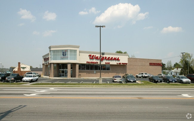
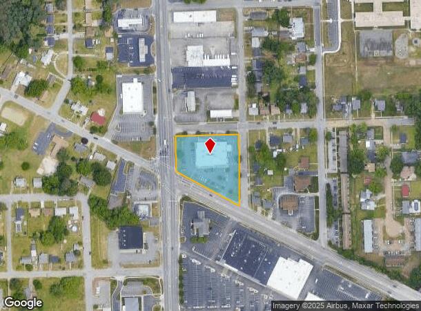
Property Record
3201 Boulevard, Colonial Heights, VA 23834
NEARBY LISTINGS FOR SALE OR LEASE
Property Detail
3201 Boulevard
Richmond, VA
Maple Grove
6300-01-0A-019
SUB: MAPLE GROVE**SECTION: 1.529 ACRE**BLOCK: A**LOT: 1-19
Drugstorepharmacycvswalgreens
Colonial Heights
X
Virginia
51041C0343E
1-19
2025
1.53 AC
2025
Colonial Heights
830200
Richmond VA
13,905 SF
DEMOGRAPHICS near 3201 Boulevard
1 Mile
3 Mile
5 Mile
2024 Total Population
7,376
36,492
94,217
2029 Population
7,517
38,045
97,793
Pop Growth 2024-2029
+ 1.91%
+ 4.26%
+ 3.80%
Average Age
42
39
39
2024 Total Households
3,155
13,882
33,222
HH Growth 2024-2029
+ 1.84%
+ 4.13%
+ 3.83%
Median Household Inc
$54,390
$61,676
$57,760
Avg Household Size
2.20
2.40
2.40
2024 Avg HH Vehicles
2.00
2.00
2.00
Median Home Value
$208,333
$205,493
$211,251
Median Year Built
1969
1972
1975
Nearby Places
Map Layers
Map Styles
 Street
 Aerial
- Restaurants
- Banks
- Shops
- Fitness
- Groceries
PUBLIC TRANSPORTATION
COMMUTER RAIL
DRIVE
WALK
Distance
8 min
3.2 mi
AIRPORT
Richmond International
DRIVE
WALK
Distance
Richmond International
37 min
24.1 mi
Freight Ports
Virginia Port Authority - Richmond
DRIVE
WALK
Distance
Virginia Port Authority - Richmond
26 min
16.4 mi
Nearby Properties
Address
Land Use
TOTAL SIZE
Lot Size
Zoning
Address
Land Use
TOTAL SIZE
Lot Size
Zoning
500 SF
390.12 AC
R7 - SINGL
Address
Land Use
TOTAL SIZE
Lot Size
Zoning
165,942 SF
0.57 AC
R7 - SINGL
Address
Land Use
TOTAL SIZE
Lot Size
Zoning
505,068 SF
60.92 AC
I2 - GEN I
Address
Land Use
TOTAL SIZE
Lot Size
Zoning
806,770 SF
129.28 AC
I2 - GEN I
Address
Land Use
TOTAL SIZE
Lot Size
Zoning
24,440 SF
16.58 AC
C4 - REGIO
Address
Land Use
TOTAL SIZE
Lot Size
Zoning
51,588 SF
13.86 AC
RMF - RES,
Address
Land Use
TOTAL SIZE
Lot Size
Zoning
157,534 SF
39.59 AC
R7 - SINGL
Address
Land Use
TOTAL SIZE
Lot Size
Zoning
482,476 SF
19.75 AC
I2 - GEN I
Address
Land Use
TOTAL SIZE
Lot Size
Zoning
752 SF
28.91 AC
R7 - SINGL
Address
Land Use
TOTAL SIZE
Lot Size
Zoning
209,515 SF
21.20 AC
B3
Address
Land Use
TOTAL SIZE
Lot Size
Zoning
95,944 SF
15.75 AC
C2 - NBHD
Address
Land Use
TOTAL SIZE
Lot Size
Zoning
188,368 SF
18.96 AC
B1
Address
Land Use
TOTAL SIZE
Lot Size
Zoning
132,121 SF
61.15 AC
I2 - GEN I
Address
Land Use
TOTAL SIZE
Lot Size
Zoning
31,800 SF
21 AC
I2 - GEN I
Address
Land Use
TOTAL SIZE
Lot Size
Zoning
130,698 SF
10.78 AC
PUD
Address
Land Use
TOTAL SIZE
Lot Size
Zoning
223,211 SF
19.99 AC
B3
Address
Land Use
TOTAL SIZE
Lot Size
Zoning
57,011 SF
4.45 AC
BB
Address
Land Use
TOTAL SIZE
Lot Size
Zoning
140,000 SF
1 AC
999
Address
Land Use
TOTAL SIZE
Lot Size
Zoning
173,829 SF
13.73 AC
B2
Address
Land Use
TOTAL SIZE
Lot Size
Zoning
129,600 SF
12.21 AC
PUD
Address
Land Use
TOTAL SIZE
Lot Size
Zoning
218,821 SF
11.47 AC
I1 - LT IN
Address
Land Use
TOTAL SIZE
Lot Size
Zoning
100 SF
12.39 AC
R7 - SINGL
Address
Land Use
TOTAL SIZE
Lot Size
Zoning
56 AC
I2 - GEN I
Address
Land Use
TOTAL SIZE
Lot Size
Zoning
56 AC
I2 - GEN I
Address
Land Use
TOTAL SIZE
Lot Size
Zoning
128,848 SF
13.24 AC
B3
Address
Land Use
TOTAL SIZE
Lot Size
Zoning
92,701 SF
2.87 AC
B1
Address
Land Use
TOTAL SIZE
Lot Size
Zoning
50,552 SF
9.33 AC
C5 - GEN B
Address
Land Use
TOTAL SIZE
Lot Size
Zoning
220,009 SF
66.16 AC
I2 - GEN I
Address
Land Use
TOTAL SIZE
Lot Size
Zoning
170,700 SF
10.22 AC
I1 - LT IN
Address
Land Use
TOTAL SIZE
Lot Size
Zoning
89,734 SF
2.85 AC
B1
The World's #1 Commercial Real Estate Marketplace
Connect with us
© 2025 CoStar Group
The information above has been obtained from sources believed reliable. While we do not doubt its accuracy we have not verified it and make no guarantee, warranty or representation about it. It is your responsibility to independently confirm its accuracy and completeness. Any projections, opinions, assumptions, or estimates used are for example only and do not represent the current or future performance of the property. The value of this transaction to you depends on tax and other factors which should be evaluated by your tax, financial, and legal advisors. You and your advisors should conduct a careful, independent investigation of the property to determine to your satisfaction the suitability of the property for your needs.