Property Record
3201 Hermann Sons Rd, Taylor, TX 76574


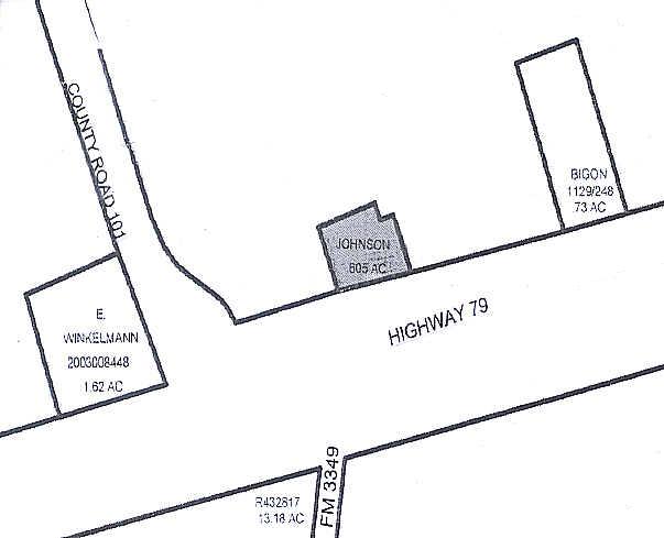
Property Detail
3201 Hermann Sons Rd
R019332
AW0348 JOHNSON, H.G. SUR., ACRES 3.456
Commercialnec
WILLIAMSON
2-M1
Texas
AE The base floodplain where base flood elevations are provided. AE Zones are now used on new format FIRMs instead of A1-A30 Zones.
3.46 AC
2024
Georgetown
2025
Austin
020808
Austin-Round Rock-San Marcos, TX
2,480 SF
NEARBY LISTINGS FOR SALE OR LEASE
DEMOGRAPHICS near 3201 Hermann Sons Rd
1 mile
3 mile
5 mile
2024 Total Population
585
18,917
21,894
2029 Population
671
21,656
25,121
Pop Growth 2024-2029
+ 14.70%
+ 14.48%
+ 14.74%
Average Age
40
40
40
2024 Total Households
227
7,068
8,169
HH Growth 2024-2029
+ 15.42%
+ 14.97%
+ 15.19%
Median Household Inc
$59,999
$72,047
$73,639
Avg Household Size
2.60
2.60
2.60
2024 Avg HH Vehicles
2.00
2.00
2.00
Median Home Value
$403,226
$324,555
$339,967
Median Year Built
1996
1983
1985
Nearby Places
Map Layers
Map Styles
 Street
 Aerial
Transit
 Traffic
 Biking
Places
Listings with unknown addresses are not visible on the map
- Restaurants
- Banks
- Shops
- Fitness
- Groceries
PUBLIC TRANSPORTATION
COMMUTER RAIL
Taylor Amtrak (Texas Eagle - Amtrak)
Drive
Walk
Distance
Taylor Amtrak (Texas Eagle - Amtrak)
7 min
3.3 mi
AIRPORT
Austin-Bergstrom International
Drive
Walk
Distance
Austin-Bergstrom International
50 min
39.1 mi
Freight Ports
Calhoun Port
Drive
Walk
Distance
Calhoun Port
211 min
182.1 mi
Nearby Properties
Address
Land Use
TOTAL SIZE
Lot Size
Zoning
Address
Land Use
TOTAL SIZE
Lot Size
Zoning
1,213.97 AC
Address
Land Use
TOTAL SIZE
Lot Size
Zoning
1,213.97 AC
Address
Land Use
TOTAL SIZE
Lot Size
Zoning
52,527 SF
1,213.97 AC
Address
Land Use
TOTAL SIZE
Lot Size
Zoning
5,060,050 SF
354.33 AC
Address
Land Use
TOTAL SIZE
Lot Size
Zoning
208,704 SF
20.56 AC
2-M1
Address
Land Use
TOTAL SIZE
Lot Size
Zoning
367,116 SF
21.71 AC
Address
Land Use
TOTAL SIZE
Lot Size
Zoning
46.70 AC
Address
Land Use
TOTAL SIZE
Lot Size
Zoning
859.64 AC
Address
Land Use
TOTAL SIZE
Lot Size
Zoning
205,355 SF
13.24 AC
Address
Land Use
TOTAL SIZE
Lot Size
Zoning
Address
Land Use
TOTAL SIZE
Lot Size
Zoning
69,997 SF
12.30 AC
3-B1
Address
Land Use
TOTAL SIZE
Lot Size
Zoning
192 SF
102.19 AC
Address
Land Use
TOTAL SIZE
Lot Size
Zoning
311,017 SF
39.81 AC
Address
Land Use
TOTAL SIZE
Lot Size
Zoning
133,666 SF
64.51 AC
2-M1
Address
Land Use
TOTAL SIZE
Lot Size
Zoning
58.91 AC
Address
Land Use
TOTAL SIZE
Lot Size
Zoning
68,657 SF
117.84 AC
2-M1
Address
Land Use
TOTAL SIZE
Lot Size
Zoning
183,955 SF
30.94 AC
Address
Land Use
TOTAL SIZE
Lot Size
Zoning
83,300 SF
10.35 AC
Address
Land Use
TOTAL SIZE
Lot Size
Zoning
60,000 SF
15.74 AC
Address
Land Use
TOTAL SIZE
Lot Size
Zoning
59.01 AC
Address
Land Use
TOTAL SIZE
Lot Size
Zoning
42.43 AC
Address
Land Use
TOTAL SIZE
Lot Size
Zoning
625 SF
51.85 AC
Address
Land Use
TOTAL SIZE
Lot Size
Zoning
72,094 SF
4.97 AC
Address
Land Use
TOTAL SIZE
Lot Size
Zoning
15.72 AC
Address
Land Use
TOTAL SIZE
Lot Size
Zoning
39,913 SF
1.54 AC
1-B3
Address
Land Use
TOTAL SIZE
Lot Size
Zoning
18.56 AC
Address
Land Use
TOTAL SIZE
Lot Size
Zoning
8.79 AC
Address
Land Use
TOTAL SIZE
Lot Size
Zoning
Address
Land Use
TOTAL SIZE
Lot Size
Zoning
29,096 SF
14.67 AC
Address
Land Use
TOTAL SIZE
Lot Size
Zoning
16,485 SF
6.75 AC
The World's #1 Commercial Real Estate Marketplace
Connect with us
© 2026 CoStar Group
The information above has been obtained from sources believed reliable. While we do not doubt its accuracy we have not verified it and make no guarantee, warranty or representation about it. It is your responsibility to independently confirm its accuracy and completeness. Any projections, opinions, assumptions, or estimates used are for example only and do not represent the current or future performance of the property. The value of this transaction to you depends on tax and other factors which should be evaluated by your tax, financial, and legal advisors. You and your advisors should conduct a careful, independent investigation of the property to determine to your satisfaction the suitability of the property for your needs.