Property Record
3201 Lavey Ln, Baker, LA 70714
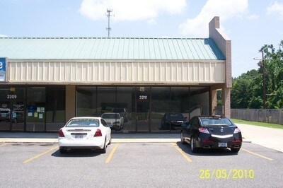
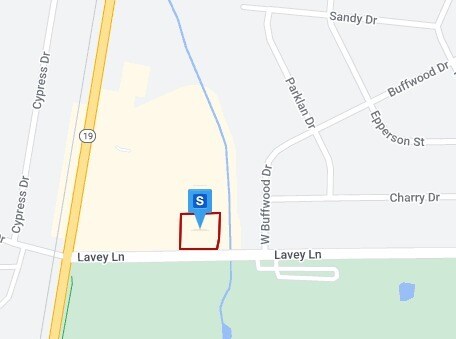
Property Detail
3201 Lavey Ln
Baton Rouge, LA
WARD: 2-2, SUBDIVISION: DUNBAR, WINDER K. TRACT, LOT: C-1-A. TRACT C-1-A, CONT. 1.77 AC., RESUB OF TRACT C, PORTION OF WINDER
00164739
East Baton Rouge
Storesoffices
Louisiana
B and X Area of moderate flood hazard, usually the area between the limits of the 100-year and 500-year floods.
c-1-a
2025
1.42 AC
2025
Greater Baton Rouge N
004205
Baton Rouge
9,544 SF
NEARBY LISTINGS FOR SALE OR LEASE
DEMOGRAPHICS near 3201 Lavey Ln
1 mile
3 mile
5 mile
2025 Total Population
3,662
23,481
54,699
2030 Population
3,590
23,406
54,593
Pop Growth 2025-2030
(1.97%)
(0.32%)
(0.19%)
Average Age
41
39
38
2025 Total Households
1,405
8,441
19,308
HH Growth 2025-2030
(2.06%)
(0.37%)
(0.24%)
Median Household Inc
$59,939
$40,983
$41,513
Avg Household Size
2.60
2.50
2.50
2025 Avg HH Vehicles
2.00
2.00
2.00
Median Home Value
$160,500
$148,856
$158,179
Median Year Built
1974
1976
1976
Nearby Places
Map Layers
Map Styles
 Street
 Aerial
Layers
 Traffic
 Biking
Places
Listings with unknown addresses are not visible on the map
- Restaurants
- Banks
- Shops
- Fitness
- Groceries
PUBLIC TRANSPORTATION
AIRPORT
Baton Rouge Metro Ryan Field
Drive
Walk
Distance
Baton Rouge Metro Ryan Field
11 min
6.0 mi
Freight Ports
Port of Greater Baton Rouge
Drive
Walk
Distance
Port of Greater Baton Rouge
24 min
14.4 mi
SALE & LEASE HISTORY
LISTING DATE
SALE/LEASE

Sep 25, 2016
For Lease
Nearby Properties
Address
Land Use
TOTAL SIZE
Lot Size
Zoning
Address
Land Use
TOTAL SIZE
Lot Size
Zoning
946,484 SF
100 AC
Address
Land Use
TOTAL SIZE
Lot Size
Zoning
Address
Land Use
TOTAL SIZE
Lot Size
Zoning
1.60 AC
Address
Land Use
TOTAL SIZE
Lot Size
Zoning
186,000 SF
23.51 AC
Address
Land Use
TOTAL SIZE
Lot Size
Zoning
45,480 SF
2.19 AC
Address
Land Use
TOTAL SIZE
Lot Size
Zoning
Address
Land Use
TOTAL SIZE
Lot Size
Zoning
34,310 SF
7.74 AC
Address
Land Use
TOTAL SIZE
Lot Size
Zoning
Address
Land Use
TOTAL SIZE
Lot Size
Zoning
86,456 SF
12.50 AC
Address
Land Use
TOTAL SIZE
Lot Size
Zoning
87.06 AC
Address
Land Use
TOTAL SIZE
Lot Size
Zoning
36.32 AC
Address
Land Use
TOTAL SIZE
Lot Size
Zoning
72,300 SF
24.63 AC
Address
Land Use
TOTAL SIZE
Lot Size
Zoning
12.59 AC
Address
Land Use
TOTAL SIZE
Lot Size
Zoning
1.42 AC
Address
Land Use
TOTAL SIZE
Lot Size
Zoning
14.99 AC
Address
Land Use
TOTAL SIZE
Lot Size
Zoning
100,000 SF
7.48 AC
Address
Land Use
TOTAL SIZE
Lot Size
Zoning
Address
Land Use
TOTAL SIZE
Lot Size
Zoning
Address
Land Use
TOTAL SIZE
Lot Size
Zoning
35,053 SF
Address
Land Use
TOTAL SIZE
Lot Size
Zoning
44,200 SF
6.53 AC
Address
Land Use
TOTAL SIZE
Lot Size
Zoning
36,750 SF
17.27 AC
Address
Land Use
TOTAL SIZE
Lot Size
Zoning
14.85 AC
Address
Land Use
TOTAL SIZE
Lot Size
Zoning
Address
Land Use
TOTAL SIZE
Lot Size
Zoning
16,583 SF
5.61 AC
Address
Land Use
TOTAL SIZE
Lot Size
Zoning
8,500 SF
3.18 AC
Address
Land Use
TOTAL SIZE
Lot Size
Zoning
4,884 SF
10.65 AC
Address
Land Use
TOTAL SIZE
Lot Size
Zoning
2.70 AC
Address
Land Use
TOTAL SIZE
Lot Size
Zoning
Address
Land Use
TOTAL SIZE
Lot Size
Zoning
2.48 AC
Address
Land Use
TOTAL SIZE
Lot Size
Zoning
9,800 SF
3.60 AC
The World's #1 Commercial Real Estate Marketplace
Connect with us
© 2026 CoStar Group
The information above has been obtained from sources believed reliable. While we do not doubt its accuracy we have not verified it and make no guarantee, warranty or representation about it. It is your responsibility to independently confirm its accuracy and completeness. Any projections, opinions, assumptions, or estimates used are for example only and do not represent the current or future performance of the property. The value of this transaction to you depends on tax and other factors which should be evaluated by your tax, financial, and legal advisors. You and your advisors should conduct a careful, independent investigation of the property to determine to your satisfaction the suitability of the property for your needs.