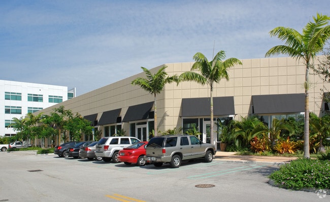
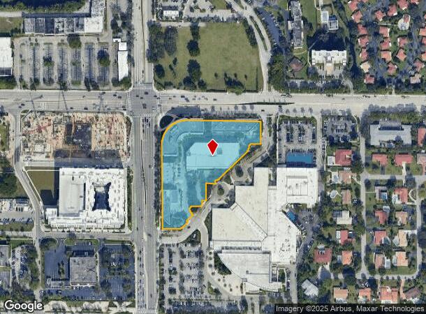
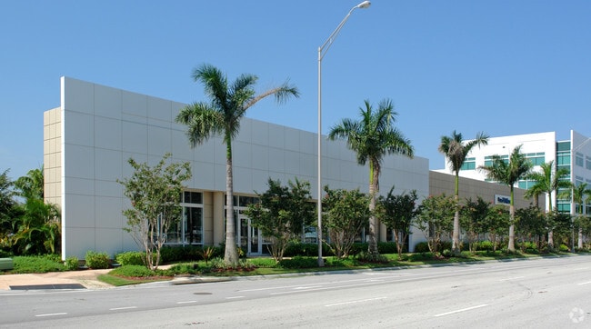
Property Record
3201 N University Dr, Coral Springs, FL 33065
Current Lease Availabilities
NEARBY LISTINGS FOR SALE OR LEASE
Property Detail
3201 N University Dr
48-41-22-20-0011
Coral Springs Charter School
Miscresidentialimprovement
CORAL SPRINGS CHARTER SCHOOL 173-118 B POR PAR A DESC AS:COMM NE COR PAR G OF CORAL SPRING VILLAGE GREEN RESUB 67-16 B,S 16 TO NE COR OF PAR A OF SAID PLAT 173-118 B,W 339.54,S 15 TO POB, S 114.41,W 45.64,SLY 24.55,SWLY 25.82,SW 194.02, WLY 20.95,S 1
X
Broward
12099C1175F
Florida
2024
3.82 AC
2025
NW Broward/Coral Springs
020323
South Florida
239,456 SF
Fort Lauderdale-Pompano Beach-Deerfield Beach, FL
DEMOGRAPHICS near 3201 N University Dr
1 Mile
3 Mile
5 Mile
2024 Total Population
22,059
145,179
334,304
2029 Population
21,796
142,749
330,759
Pop Growth 2024-2029
(1.19%)
(1.67%)
(1.06%)
Average Age
38
40
40
2024 Total Households
7,889
50,759
120,888
HH Growth 2024-2029
(1.75%)
(2.15%)
(1.46%)
Median Household Inc
$55,821
$77,907
$71,810
Avg Household Size
2.70
2.70
2.70
2024 Avg HH Vehicles
2.00
2.00
2.00
Median Home Value
$339,767
$382,171
$333,692
Median Year Built
1979
1983
1985
Nearby Places
- Restaurants
- Banks
- Shops
- Fitness
- Groceries
PUBLIC TRANSPORTATION
COMMUTER RAIL
Pompano Beach (Tri-County Commuter - South Florida Regional Transportation Authority (Tri-Rail))
DRIVE
WALK
Distance
Pompano Beach (Tri-County Commuter - South Florida Regional Transportation Authority (Tri-Rail))
16 min
7.8 mi
AIRPORT
Fort Lauderdale/Hollywood International
DRIVE
WALK
Distance
Fort Lauderdale/Hollywood International
37 min
22.3 mi
Palm Beach International
DRIVE
WALK
Distance
Palm Beach International
52 min
38.9 mi
Freight Ports
Port Everglades
DRIVE
WALK
Distance
Port Everglades
36 min
20.9 mi
Nearby Properties
Address
Land Use
TOTAL SIZE
Lot Size
Zoning
Address
Land Use
TOTAL SIZE
Lot Size
Zoning
447,756 SF
45.30 AC
BCRM-5
Address
Land Use
TOTAL SIZE
Lot Size
Zoning
457,406 SF
21.26 AC
MC
Address
Land Use
TOTAL SIZE
Lot Size
Zoning
640,399 SF
2.41 AC
Address
Land Use
TOTAL SIZE
Lot Size
Zoning
641,010 SF
29.99 AC
RM-20
Address
Land Use
TOTAL SIZE
Lot Size
Zoning
399,296 SF
20.23 AC
RM-40
Address
Land Use
TOTAL SIZE
Lot Size
Zoning
451,337 SF
33.01 AC
R-3A
Address
Land Use
TOTAL SIZE
Lot Size
Zoning
344,358 SF
23.27 AC
RM-20
Address
Land Use
TOTAL SIZE
Lot Size
Zoning
572,683 SF
38.41 AC
IRD
Address
Land Use
TOTAL SIZE
Lot Size
Zoning
500,974 SF
16.20 AC
CF-1
Address
Land Use
TOTAL SIZE
Lot Size
Zoning
347,840 SF
16.76 AC
RM-20
Address
Land Use
TOTAL SIZE
Lot Size
Zoning
276,412 SF
10.40 AC
TOC-G
Address
Land Use
TOTAL SIZE
Lot Size
Zoning
278,336 SF
15.85 AC
RM-20
Address
Land Use
TOTAL SIZE
Lot Size
Zoning
354,535 SF
33.95 AC
RM-15
Address
Land Use
TOTAL SIZE
Lot Size
Zoning
294,706 SF
17.10 AC
RM-20
Address
Land Use
TOTAL SIZE
Lot Size
Zoning
345,189 SF
9.66 AC
RM-30
Address
Land Use
TOTAL SIZE
Lot Size
Zoning
421,001 SF
44.62 AC
CF
Address
Land Use
TOTAL SIZE
Lot Size
Zoning
345,021 SF
13.79 AC
RM-20
Address
Land Use
TOTAL SIZE
Lot Size
Zoning
293,096 SF
11.84 AC
RM-20
Address
Land Use
TOTAL SIZE
Lot Size
Zoning
260,897 SF
12.62 AC
RM-20
Address
Land Use
TOTAL SIZE
Lot Size
Zoning
566,155 SF
38.24 AC
B-3
Address
Land Use
TOTAL SIZE
Lot Size
Zoning
391,305 SF
30.78 AC
CF-E
Address
Land Use
TOTAL SIZE
Lot Size
Zoning
311,836 SF
13.92 AC
RM-30
Address
Land Use
TOTAL SIZE
Lot Size
Zoning
157,914 SF
15.11 AC
B-3
Address
Land Use
TOTAL SIZE
Lot Size
Zoning
401,920 SF
16.93 AC
RM-15
Address
Land Use
TOTAL SIZE
Lot Size
Zoning
440,886 SF
23.17 AC
IRD
Address
Land Use
TOTAL SIZE
Lot Size
Zoning
349,250 SF
19.90 AC
CF
Address
Land Use
TOTAL SIZE
Lot Size
Zoning
304,837 SF
32.08 AC
CF-E
Address
Land Use
TOTAL SIZE
Lot Size
Zoning
242,692 SF
17.25 AC
RM-20
Address
Land Use
TOTAL SIZE
Lot Size
Zoning
202,587 SF
11.01 AC
R-3A
Address
Land Use
TOTAL SIZE
Lot Size
Zoning
353,516 SF
33.96 AC
CF-E
The World's #1 Commercial Real Estate Marketplace
Connect with us
© 2025 CoStar Group
The information above has been obtained from sources believed reliable. While we do not doubt its accuracy we have not verified it and make no guarantee, warranty or representation about it. It is your responsibility to independently confirm its accuracy and completeness. Any projections, opinions, assumptions, or estimates used are for example only and do not represent the current or future performance of the property. The value of this transaction to you depends on tax and other factors which should be evaluated by your tax, financial, and legal advisors. You and your advisors should conduct a careful, independent investigation of the property to determine to your satisfaction the suitability of the property for your needs.