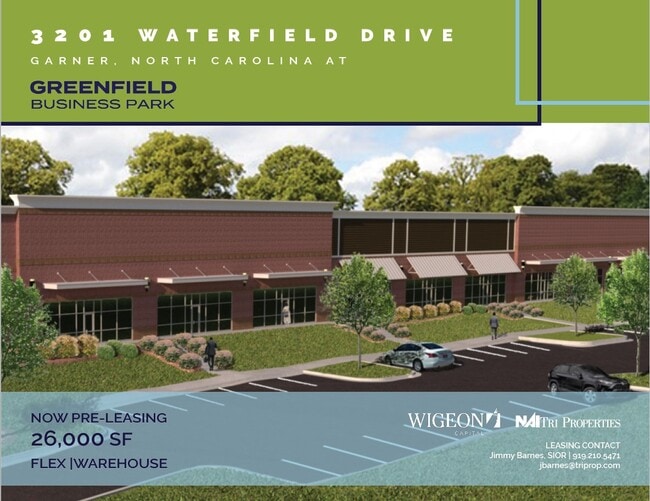
Property Record
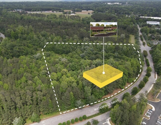
3201 Waterfield Dr, Garner, NC 27529

Current Lease Availabilities
NEARBY LISTINGS FOR SALE OR LEASE
Property Detail
3201 Waterfield Dr
Raleigh, NC
Vanguard Ventures Ii Eat Llc
1730.03-03-3129-000
VANGUARD VENTURES II EAT LLC EASE DEDI B
Vacantlandnec
Wake
AE
North Carolina
3720173000K
12
2025
5.34 AC
2025
Southeast Wake County
052809
Raleigh/Durham
DEMOGRAPHICS near 3201 Waterfield Dr
1 Mile
3 Mile
5 Mile
2024 Total Population
3,650
20,560
80,904
2029 Population
4,069
22,877
89,946
Pop Growth 2024-2029
+ 11.48%
+ 11.27%
+ 11.18%
Average Age
37
39
39
2024 Total Households
1,725
8,179
30,024
HH Growth 2024-2029
+ 11.54%
+ 11.28%
+ 11.30%
Median Household Inc
$51,702
$73,412
$74,142
Avg Household Size
2.10
2.40
2.60
2024 Avg HH Vehicles
2.00
2.00
2.00
Median Home Value
$265,315
$301,800
$258,758
Median Year Built
2008
2005
1999
Nearby Places
Map Layers
Map Styles
 Street
 Aerial
- Restaurants
- Banks
- Shops
- Fitness
- Groceries
PUBLIC TRANSPORTATION
AIRPORT
Raleigh-Durham International
DRIVE
WALK
Distance
Raleigh-Durham International
35 min
25.2 mi
Freight Ports
Port of Wilmington
DRIVE
WALK
Distance
Port of Wilmington
145 min
126.8 mi
Nearby Properties
Address
Land Use
TOTAL SIZE
Lot Size
Zoning
Address
Land Use
TOTAL SIZE
Lot Size
Zoning
2,583,746 SF
87.16 AC
HI
Address
Land Use
TOTAL SIZE
Lot Size
Zoning
323,031 SF
57.73 AC
R4
Address
Land Use
TOTAL SIZE
Lot Size
Zoning
435,270 SF
57.90 AC
CMX
Address
Land Use
TOTAL SIZE
Lot Size
Zoning
390,672 SF
30.23 AC
CMX
Address
Land Use
TOTAL SIZE
Lot Size
Zoning
288,761 SF
19.61 AC
MF-B
Address
Land Use
TOTAL SIZE
Lot Size
Zoning
298,563 SF
24.19 AC
CMX
Address
Land Use
TOTAL SIZE
Lot Size
Zoning
279,123 SF
22.91 AC
CMX
Address
Land Use
TOTAL SIZE
Lot Size
Zoning
304,813 SF
19.08 AC
MF-A
Address
Land Use
TOTAL SIZE
Lot Size
Zoning
250,558 SF
23.49 AC
CMX
Address
Land Use
TOTAL SIZE
Lot Size
Zoning
203,766 SF
14.18 AC
MF-A
Address
Land Use
TOTAL SIZE
Lot Size
Zoning
220,352 SF
16.82 AC
MF-A
Address
Land Use
TOTAL SIZE
Lot Size
Zoning
225,000 SF
22.47 AC
HI
Address
Land Use
TOTAL SIZE
Lot Size
Zoning
275,215 SF
18.17 AC
HI
Address
Land Use
TOTAL SIZE
Lot Size
Zoning
112,243 SF
45.76 AC
RA
Address
Land Use
TOTAL SIZE
Lot Size
Zoning
259,480 SF
17.19 AC
HI
Address
Land Use
TOTAL SIZE
Lot Size
Zoning
240,000 SF
15.55 AC
LI
Address
Land Use
TOTAL SIZE
Lot Size
Zoning
2,527 SF
173.31 AC
CMX
Address
Land Use
TOTAL SIZE
Lot Size
Zoning
110,680 SF
107.82 AC
IH
Address
Land Use
TOTAL SIZE
Lot Size
Zoning
99,963 SF
26.84 AC
R2
Address
Land Use
TOTAL SIZE
Lot Size
Zoning
166,413 SF
12.47 AC
HI
Address
Land Use
TOTAL SIZE
Lot Size
Zoning
127,932 SF
16.44 AC
LI
Address
Land Use
TOTAL SIZE
Lot Size
Zoning
153,099 SF
38.98 AC
R2
Address
Land Use
TOTAL SIZE
Lot Size
Zoning
78,409 SF
45.91 AC
RA
Address
Land Use
TOTAL SIZE
Lot Size
Zoning
187,500 SF
12.43 AC
IH
Address
Land Use
TOTAL SIZE
Lot Size
Zoning
180,000 SF
10.77 AC
LI
Address
Land Use
TOTAL SIZE
Lot Size
Zoning
125,880 SF
6.37 AC
HI
Address
Land Use
TOTAL SIZE
Lot Size
Zoning
133,889 SF
19.90 AC
HI
Address
Land Use
TOTAL SIZE
Lot Size
Zoning
150,662 SF
10.25 AC
HI
Address
Land Use
TOTAL SIZE
Lot Size
Zoning
160,380 SF
12.25 AC
LI
Address
Land Use
TOTAL SIZE
Lot Size
Zoning
94,554 SF
7.78 AC
MF-A
The World's #1 Commercial Real Estate Marketplace
Connect with us
© 2025 CoStar Group
The information above has been obtained from sources believed reliable. While we do not doubt its accuracy we have not verified it and make no guarantee, warranty or representation about it. It is your responsibility to independently confirm its accuracy and completeness. Any projections, opinions, assumptions, or estimates used are for example only and do not represent the current or future performance of the property. The value of this transaction to you depends on tax and other factors which should be evaluated by your tax, financial, and legal advisors. You and your advisors should conduct a careful, independent investigation of the property to determine to your satisfaction the suitability of the property for your needs.