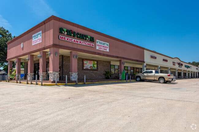
Property Record
32015 Highway 249, Magnolia, TX 77355

NEARBY LISTINGS FOR SALE OR LEASE
Property Detail
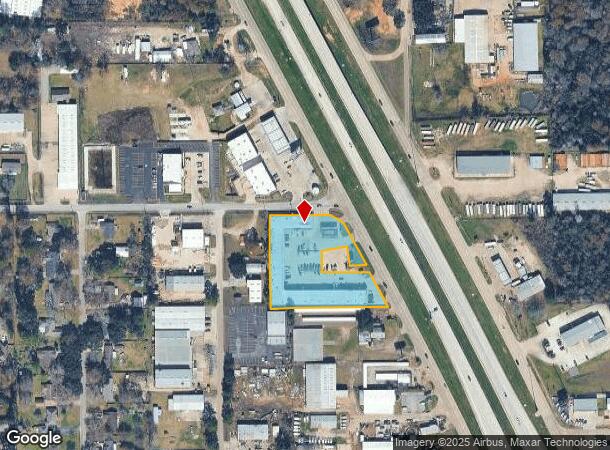
32015 Highway 249
3758-00-90006
Decker Prairie Ind Pk
Commercialnec
S375800 - DECKER PRAIRIE IND PK, PARCEL D-1 (DECKER PINES SHPG CTR), ACRES 2.0786
X
Montgomery
48339C0495G
Texas
2024
2.08 AC
2025
Montgomery County
690205
Houston
27,450 SF
Houston-The Woodlands-Sugar Land, TX
DEMOGRAPHICS near 32015 Highway 249
1 Mile
3 Mile
5 Mile
2024 Total Population
3,826
20,998
55,716
2029 Population
4,663
24,377
64,521
Pop Growth 2024-2029
+ 21.88%
+ 16.09%
+ 15.80%
Average Age
37
39
39
2024 Total Households
1,277
7,332
19,523
HH Growth 2024-2029
+ 22.00%
+ 15.58%
+ 15.23%
Median Household Inc
$95,152
$97,238
$87,276
Avg Household Size
2.90
2.80
2.80
2024 Avg HH Vehicles
2.00
2.00
2.00
Median Home Value
$242,090
$335,734
$335,196
Median Year Built
2003
1998
2002
Nearby Places
Map Layers
Map Styles
 Street
 Aerial
- Restaurants
- Banks
- Shops
- Fitness
- Groceries
PUBLIC TRANSPORTATION
AIRPORT
George Bush Intcntl/Houston
DRIVE
WALK
Distance
George Bush Intcntl/Houston
37 min
30.3 mi
Freight Ports
Port of Houston
DRIVE
WALK
Distance
Port of Houston
57 min
41.0 mi
SALE & LEASE HISTORY
LISTING DATE
SALE/LEASE

Nov 14, 2023
For Lease
Mar 04, 2019
For Sale
Jun 28, 2021
For Sale
Apr 23, 2020
For Lease
Apr 03, 2021
For Sale
Nearby Properties
Address
Land Use
TOTAL SIZE
Lot Size
Zoning
Address
Land Use
TOTAL SIZE
Lot Size
Zoning
146,990 SF
7.02 AC
Address
Land Use
TOTAL SIZE
Lot Size
Zoning
112,854 SF
5.80 AC
Address
Land Use
TOTAL SIZE
Lot Size
Zoning
118,004 SF
5.55 AC
Address
Land Use
TOTAL SIZE
Lot Size
Zoning
135,804 SF
15.33 AC
Address
Land Use
TOTAL SIZE
Lot Size
Zoning
65,475 SF
7.84 AC
Address
Land Use
TOTAL SIZE
Lot Size
Zoning
104,859 SF
5.29 AC
Address
Land Use
TOTAL SIZE
Lot Size
Zoning
73,992 SF
7.21 AC
Address
Land Use
TOTAL SIZE
Lot Size
Zoning
122,970 SF
11.79 AC
Address
Land Use
TOTAL SIZE
Lot Size
Zoning
81,277 SF
4.43 AC
Address
Land Use
TOTAL SIZE
Lot Size
Zoning
87,278 SF
2.65 AC
I2
Address
Land Use
TOTAL SIZE
Lot Size
Zoning
14,865 SF
1.98 AC
2
Address
Land Use
TOTAL SIZE
Lot Size
Zoning
90,311 SF
10 AC
Address
Land Use
TOTAL SIZE
Lot Size
Zoning
7,800 SF
18.47 AC
Address
Land Use
TOTAL SIZE
Lot Size
Zoning
100,389 SF
5.47 AC
2
Address
Land Use
TOTAL SIZE
Lot Size
Zoning
1,184 SF
27.54 AC
Address
Land Use
TOTAL SIZE
Lot Size
Zoning
48,896 SF
2 AC
Address
Land Use
TOTAL SIZE
Lot Size
Zoning
67,125 SF
10.41 AC
Address
Land Use
TOTAL SIZE
Lot Size
Zoning
20,994 SF
1.27 AC
Address
Land Use
TOTAL SIZE
Lot Size
Zoning
1,722 SF
31.19 AC
2
Address
Land Use
TOTAL SIZE
Lot Size
Zoning
25,050 SF
2.16 AC
Address
Land Use
TOTAL SIZE
Lot Size
Zoning
12,276 SF
4.81 AC
Address
Land Use
TOTAL SIZE
Lot Size
Zoning
40.23 AC
Address
Land Use
TOTAL SIZE
Lot Size
Zoning
43,400 SF
6.05 AC
2
Address
Land Use
TOTAL SIZE
Lot Size
Zoning
22,650 SF
2.03 AC
Address
Land Use
TOTAL SIZE
Lot Size
Zoning
28,400 SF
3.85 AC
Address
Land Use
TOTAL SIZE
Lot Size
Zoning
4,365 SF
0.99 AC
Address
Land Use
TOTAL SIZE
Lot Size
Zoning
29,682 SF
2.41 AC
Address
Land Use
TOTAL SIZE
Lot Size
Zoning
13,545 SF
4.56 AC
2
Address
Land Use
TOTAL SIZE
Lot Size
Zoning
5,252 SF
1.20 AC
Address
Land Use
TOTAL SIZE
Lot Size
Zoning
2,566 SF
31.34 AC
The World's #1 Commercial Real Estate Marketplace
Connect with us
© 2025 CoStar Group
The information above has been obtained from sources believed reliable. While we do not doubt its accuracy we have not verified it and make no guarantee, warranty or representation about it. It is your responsibility to independently confirm its accuracy and completeness. Any projections, opinions, assumptions, or estimates used are for example only and do not represent the current or future performance of the property. The value of this transaction to you depends on tax and other factors which should be evaluated by your tax, financial, and legal advisors. You and your advisors should conduct a careful, independent investigation of the property to determine to your satisfaction the suitability of the property for your needs.