Property Record
3202 W Cherry Ridge Dr, San Antonio, TX 78230


Save to a Folder
{{folder.Name}}
{{folder.ListingIds.length}} Properties
{{folder.ListingIds.length}} Property
Create a New Folder
Property Detail
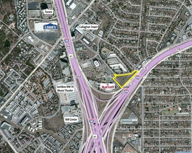
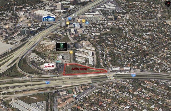
3202 W Cherry Ridge Dr
San Antonio-New Braunfels, TX
NCB 13382 BLK 16 LOT 14 (GREENBRIAR UT-13) PER PLAT 9566/33-34 FILED 7-5-05
13382-016-0140
BEXAR
Medicalbuilding
Texas
B and X Area of moderate flood hazard, usually the area between the limits of the 100-year and 500-year floods.
14
2025
2.57 AC
2025
Northwest
181001
San Antonio
18,624 SF
NEARBY LISTINGS FOR SALE OR LEASE
DEMOGRAPHICS near 3202 W Cherry Ridge Dr
1 mile
3 mile
5 mile
2025 Total Population
16,934
153,588
374,805
2030 Population
17,665
161,220
393,170
Pop Growth 2025-2030
+ 4.32%
+ 4.97%
+ 4.90%
Average Age
37
38
39
2025 Total Households
7,240
65,673
157,363
HH Growth 2025-2030
+ 4.56%
+ 5.24%
+ 5.17%
Median Household Inc
$49,771
$53,041
$56,728
Avg Household Size
2.30
2.30
2.30
2025 Avg HH Vehicles
2.00
2.00
2.00
Median Home Value
$226,316
$247,413
$267,346
Median Year Built
1971
1975
1977
Nearby Places
Map Layers
Map Styles
 Street
 Aerial
Layers
 Traffic
 Biking
Places
Listings with unknown addresses are not visible on the map
- Restaurants
- Banks
- Shops
- Fitness
- Groceries
PUBLIC TRANSPORTATION
COMMUTER RAIL
Drive
Walk
Distance
16 min
9.8 mi
AIRPORT
San Antonio International
Drive
Walk
Distance
San Antonio International
8 min
4.9 mi
SALE & LEASE HISTORY
LISTING DATE
SALE/LEASE

Sep 24, 2016
For Sale
Aug 25, 2017
For Sale
Nearby Properties
Address
Land Use
TOTAL SIZE
Lot Size
Zoning
Address
Land Use
TOTAL SIZE
Lot Size
Zoning
1,414,945 SF
16.77 AC
Address
Land Use
TOTAL SIZE
Lot Size
Zoning
4,465,972 SF
231.60 AC
Address
Land Use
TOTAL SIZE
Lot Size
Zoning
609,267 SF
30.47 AC
Address
Land Use
TOTAL SIZE
Lot Size
Zoning
429,561 SF
25.70 AC
Address
Land Use
TOTAL SIZE
Lot Size
Zoning
97.47 AC
Address
Land Use
TOTAL SIZE
Lot Size
Zoning
724,148 SF
18.70 AC
Address
Land Use
TOTAL SIZE
Lot Size
Zoning
278,352 SF
10 AC
Address
Land Use
TOTAL SIZE
Lot Size
Zoning
306,959 SF
15.24 AC
Address
Land Use
TOTAL SIZE
Lot Size
Zoning
482,412 SF
22.97 AC
Address
Land Use
TOTAL SIZE
Lot Size
Zoning
227,744 SF
3.99 AC
Address
Land Use
TOTAL SIZE
Lot Size
Zoning
239,623 SF
26.63 AC
Address
Land Use
TOTAL SIZE
Lot Size
Zoning
506,058 SF
25.23 AC
Address
Land Use
TOTAL SIZE
Lot Size
Zoning
201,339 SF
9.32 AC
Address
Land Use
TOTAL SIZE
Lot Size
Zoning
288,719 SF
14.66 AC
Address
Land Use
TOTAL SIZE
Lot Size
Zoning
152,676 SF
13.74 AC
Address
Land Use
TOTAL SIZE
Lot Size
Zoning
495,484 SF
5.81 AC
Address
Land Use
TOTAL SIZE
Lot Size
Zoning
61.64 AC
Address
Land Use
TOTAL SIZE
Lot Size
Zoning
305,379 SF
12.04 AC
Address
Land Use
TOTAL SIZE
Lot Size
Zoning
219,400 SF
6.16 AC
Address
Land Use
TOTAL SIZE
Lot Size
Zoning
259,934 SF
9.81 AC
Address
Land Use
TOTAL SIZE
Lot Size
Zoning
402,327 SF
16.65 AC
Address
Land Use
TOTAL SIZE
Lot Size
Zoning
211,045 SF
8.08 AC
Address
Land Use
TOTAL SIZE
Lot Size
Zoning
8,508 SF
3.34 AC
Address
Land Use
TOTAL SIZE
Lot Size
Zoning
221,778 SF
16.31 AC
Address
Land Use
TOTAL SIZE
Lot Size
Zoning
63.25 AC
Address
Land Use
TOTAL SIZE
Lot Size
Zoning
232,398 SF
12.66 AC
Address
Land Use
TOTAL SIZE
Lot Size
Zoning
392,678 SF
21.04 AC
Address
Land Use
TOTAL SIZE
Lot Size
Zoning
211,182 SF
6.73 AC
Address
Land Use
TOTAL SIZE
Lot Size
Zoning
210,731 SF
14.15 AC
Address
Land Use
TOTAL SIZE
Lot Size
Zoning
291,385 SF
16.19 AC
The World's #1 Commercial Real Estate Marketplace
Connect with us
© 2026 CoStar Group
The information above has been obtained from sources believed reliable. While we do not doubt its accuracy we have not verified it and make no guarantee, warranty or representation about it. It is your responsibility to independently confirm its accuracy and completeness. Any projections, opinions, assumptions, or estimates used are for example only and do not represent the current or future performance of the property. The value of this transaction to you depends on tax and other factors which should be evaluated by your tax, financial, and legal advisors. You and your advisors should conduct a careful, independent investigation of the property to determine to your satisfaction the suitability of the property for your needs.