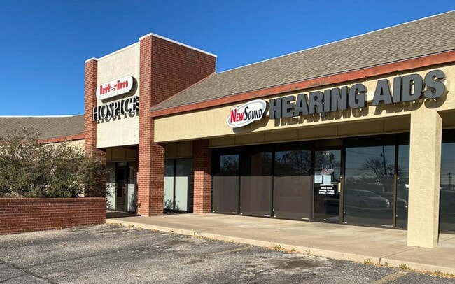
Property Record
3202 Sherwood Way, San Angelo, TX 76901

NEARBY LISTINGS FOR SALE OR LEASE
Property Detail
3202 Sherwood Way
14-26900-0106-007-10
Hatcher Add
Storebuilding
ACRES: 5.278 SUBD: HATCHER ADDITION 5.277 ACS OUT OF & PART OF BLKS 106 THRU 109 & STS & ALLEYS INCLUSIVE
X
Tom Green
48451C0480E
Texas
2025
5.28 AC
2025
Texas West Area
001101
Other Market Areas
50,351 SF
San Angelo, TX
DEMOGRAPHICS near 3202 Sherwood Way
1 Mile
3 Mile
5 Mile
2024 Total Population
10,160
59,290
93,940
2029 Population
10,068
58,978
93,582
Pop Growth 2024-2029
(0.91%)
(0.53%)
(0.38%)
Average Age
36
38
38
2024 Total Households
4,036
24,432
37,339
HH Growth 2024-2029
(0.94%)
(0.57%)
(0.40%)
Median Household Inc
$66,272
$63,125
$60,418
Avg Household Size
2.50
2.30
2.40
2024 Avg HH Vehicles
2.00
2.00
2.00
Median Home Value
$147,539
$167,300
$157,963
Median Year Built
1967
1976
1974
Nearby Places
Map Layers
Map Styles
 Street
 Aerial
- Restaurants
- Banks
- Shops
- Fitness
- Groceries
PUBLIC TRANSPORTATION
AIRPORT
San Angelo Regional/Mathis Field
DRIVE
WALK
Distance
San Angelo Regional/Mathis Field
16 min
8.6 mi
Freight Ports
Calhoun Port
DRIVE
WALK
Distance
Calhoun Port
399 min
360.9 mi
SALE & LEASE HISTORY
LISTING DATE
SALE/LEASE

Oct 02, 2018
For Lease
Nearby Properties
Address
Land Use
TOTAL SIZE
Lot Size
Zoning
Address
Land Use
TOTAL SIZE
Lot Size
Zoning
189,402 SF
18.09 AC
Address
Land Use
TOTAL SIZE
Lot Size
Zoning
205,985 SF
15 AC
Address
Land Use
TOTAL SIZE
Lot Size
Zoning
159,960 SF
8.77 AC
Address
Land Use
TOTAL SIZE
Lot Size
Zoning
203,856 SF
32.06 AC
Address
Land Use
TOTAL SIZE
Lot Size
Zoning
183,667 SF
10.74 AC
Address
Land Use
TOTAL SIZE
Lot Size
Zoning
230,352 SF
14.95 AC
Address
Land Use
TOTAL SIZE
Lot Size
Zoning
159,506 SF
9.76 AC
Address
Land Use
TOTAL SIZE
Lot Size
Zoning
171,120 SF
9.46 AC
Address
Land Use
TOTAL SIZE
Lot Size
Zoning
53,850 SF
6.15 AC
Address
Land Use
TOTAL SIZE
Lot Size
Zoning
91,978 SF
8.42 AC
Address
Land Use
TOTAL SIZE
Lot Size
Zoning
142,715 SF
8.22 AC
Address
Land Use
TOTAL SIZE
Lot Size
Zoning
149,980 SF
9.42 AC
Address
Land Use
TOTAL SIZE
Lot Size
Zoning
202,670 SF
23.87 AC
Address
Land Use
TOTAL SIZE
Lot Size
Zoning
147,240 SF
8.91 AC
Address
Land Use
TOTAL SIZE
Lot Size
Zoning
164,896 SF
11.83 AC
Address
Land Use
TOTAL SIZE
Lot Size
Zoning
196,559 SF
20.89 AC
Address
Land Use
TOTAL SIZE
Lot Size
Zoning
26,375 SF
7.69 AC
Address
Land Use
TOTAL SIZE
Lot Size
Zoning
149,516 SF
7.40 AC
Address
Land Use
TOTAL SIZE
Lot Size
Zoning
176,654 SF
21.57 AC
Address
Land Use
TOTAL SIZE
Lot Size
Zoning
149,703 SF
8.53 AC
Address
Land Use
TOTAL SIZE
Lot Size
Zoning
36,000 SF
6.42 AC
Address
Land Use
TOTAL SIZE
Lot Size
Zoning
320,000 SF
21.48 AC
Address
Land Use
TOTAL SIZE
Lot Size
Zoning
242,426 SF
9.04 AC
Address
Land Use
TOTAL SIZE
Lot Size
Zoning
58,282 SF
5.19 AC
Address
Land Use
TOTAL SIZE
Lot Size
Zoning
121,135 SF
9.51 AC
Address
Land Use
TOTAL SIZE
Lot Size
Zoning
141,720 SF
7.56 AC
Address
Land Use
TOTAL SIZE
Lot Size
Zoning
93,987 SF
13.86 AC
Address
Land Use
TOTAL SIZE
Lot Size
Zoning
122,320 SF
6 AC
Address
Land Use
TOTAL SIZE
Lot Size
Zoning
Address
Land Use
TOTAL SIZE
Lot Size
Zoning
100,352 SF
7.31 AC
The World's #1 Commercial Real Estate Marketplace
Connect with us
© 2026 CoStar Group
The information above has been obtained from sources believed reliable. While we do not doubt its accuracy we have not verified it and make no guarantee, warranty or representation about it. It is your responsibility to independently confirm its accuracy and completeness. Any projections, opinions, assumptions, or estimates used are for example only and do not represent the current or future performance of the property. The value of this transaction to you depends on tax and other factors which should be evaluated by your tax, financial, and legal advisors. You and your advisors should conduct a careful, independent investigation of the property to determine to your satisfaction the suitability of the property for your needs.