Property Record
32026 State Highway 249, Pinehurst, TX 77362
NEARBY LISTINGS FOR SALE OR LEASE
Property Detail
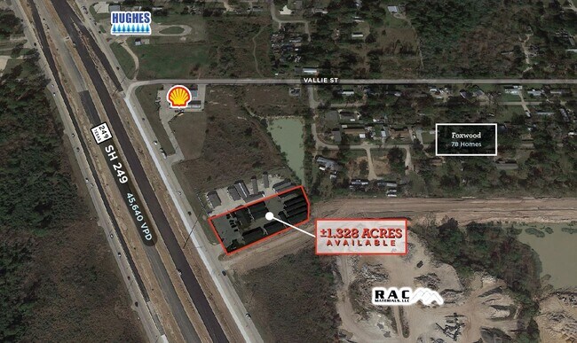
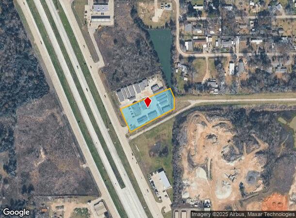
32026 State Highway 249
Houston-Pasadena-The Woodlands, TX
Decker Prairie Commercial Park
3761-00-00100
S376100 - DECKER PRAIRIE COMMERCIAL PARK, BLOCK 1, LOT 1, ACRES 1.328
Commercialnec
Montgomery
AE
Texas
48339C0495G
1
2024
1.33 AC
2025
Northwest Outlier
690207
Houston
2,516 SF
DEMOGRAPHICS near 32026 State Highway 249
1 Mile
3 Mile
5 Mile
2024 Total Population
3,633
23,404
57,785
2029 Population
4,288
26,558
66,206
Pop Growth 2024-2029
+ 18.03%
+ 13.48%
+ 14.57%
Average Age
37
40
39
2024 Total Households
1,235
8,485
20,237
HH Growth 2024-2029
+ 17.81%
+ 12.75%
+ 14.07%
Median Household Inc
$99,944
$86,579
$89,680
Avg Household Size
2.90
2.70
2.80
2024 Avg HH Vehicles
2.00
2.00
2.00
Median Home Value
$258,172
$331,033
$344,841
Median Year Built
2002
1996
2004
Nearby Places
Map Layers
Map Styles
 Street
 Aerial
- Restaurants
- Banks
- Shops
- Fitness
- Groceries
PUBLIC TRANSPORTATION
AIRPORT
George Bush Intcntl/Houston
DRIVE
WALK
Distance
George Bush Intcntl/Houston
39 min
31.2 mi
Freight Ports
Port of Houston
DRIVE
WALK
Distance
Port of Houston
59 min
41.9 mi
SALE & LEASE HISTORY
LISTING DATE
SALE/LEASE

Sep 24, 2016
For Sale
Apr 01, 2017
For Sale
Nearby Properties
Address
Land Use
TOTAL SIZE
Lot Size
Zoning
Address
Land Use
TOTAL SIZE
Lot Size
Zoning
148,105 SF
19.73 AC
Address
Land Use
TOTAL SIZE
Lot Size
Zoning
179,083 SF
8.29 AC
Address
Land Use
TOTAL SIZE
Lot Size
Zoning
142,427 SF
12.02 AC
Address
Land Use
TOTAL SIZE
Lot Size
Zoning
110,553 SF
10.34 AC
Address
Land Use
TOTAL SIZE
Lot Size
Zoning
176,180 SF
7.28 AC
Address
Land Use
TOTAL SIZE
Lot Size
Zoning
146,990 SF
7.02 AC
Address
Land Use
TOTAL SIZE
Lot Size
Zoning
59,119 SF
6.26 AC
Address
Land Use
TOTAL SIZE
Lot Size
Zoning
112,854 SF
5.80 AC
Address
Land Use
TOTAL SIZE
Lot Size
Zoning
118,004 SF
5.55 AC
Address
Land Use
TOTAL SIZE
Lot Size
Zoning
103,000 SF
8.36 AC
Address
Land Use
TOTAL SIZE
Lot Size
Zoning
88,950 SF
12.24 AC
Address
Land Use
TOTAL SIZE
Lot Size
Zoning
135,804 SF
15.33 AC
Address
Land Use
TOTAL SIZE
Lot Size
Zoning
70,192 SF
2.20 AC
Address
Land Use
TOTAL SIZE
Lot Size
Zoning
65,475 SF
7.84 AC
Address
Land Use
TOTAL SIZE
Lot Size
Zoning
104,859 SF
5.29 AC
Address
Land Use
TOTAL SIZE
Lot Size
Zoning
54,323 SF
3.66 AC
Address
Land Use
TOTAL SIZE
Lot Size
Zoning
73,992 SF
7.21 AC
Address
Land Use
TOTAL SIZE
Lot Size
Zoning
122,970 SF
11.79 AC
Address
Land Use
TOTAL SIZE
Lot Size
Zoning
81,277 SF
4.43 AC
Address
Land Use
TOTAL SIZE
Lot Size
Zoning
41,541 SF
3.93 AC
Address
Land Use
TOTAL SIZE
Lot Size
Zoning
86,551 SF
6.97 AC
Address
Land Use
TOTAL SIZE
Lot Size
Zoning
24,483 SF
9.66 AC
Address
Land Use
TOTAL SIZE
Lot Size
Zoning
50,061 SF
1.73 AC
Address
Land Use
TOTAL SIZE
Lot Size
Zoning
87,278 SF
2.65 AC
I2
Address
Land Use
TOTAL SIZE
Lot Size
Zoning
14,865 SF
1.98 AC
2
Address
Land Use
TOTAL SIZE
Lot Size
Zoning
42,900 SF
2.11 AC
Address
Land Use
TOTAL SIZE
Lot Size
Zoning
64,986 SF
4.75 AC
Address
Land Use
TOTAL SIZE
Lot Size
Zoning
81,175 SF
3.31 AC
Address
Land Use
TOTAL SIZE
Lot Size
Zoning
90,311 SF
10 AC
Address
Land Use
TOTAL SIZE
Lot Size
Zoning
7,800 SF
18.47 AC
The World's #1 Commercial Real Estate Marketplace
Connect with us
© 2026 CoStar Group
The information above has been obtained from sources believed reliable. While we do not doubt its accuracy we have not verified it and make no guarantee, warranty or representation about it. It is your responsibility to independently confirm its accuracy and completeness. Any projections, opinions, assumptions, or estimates used are for example only and do not represent the current or future performance of the property. The value of this transaction to you depends on tax and other factors which should be evaluated by your tax, financial, and legal advisors. You and your advisors should conduct a careful, independent investigation of the property to determine to your satisfaction the suitability of the property for your needs.