Property Record
3203 E Graves Rd, Mead, WA 99021
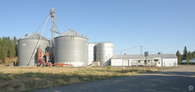
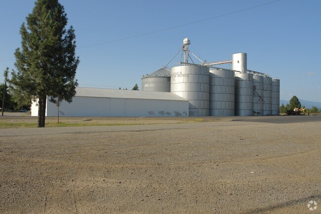

Property Detail
3203 E Graves Rd
Spokane-Spokane Valley, WA
HILTONS ADD L12 B3; TOG W VAC 2ND AVE LYG S OF AND ADJ
36156.9023
SPOKANE
Vacantlandnec
Washington
HI
12
B and X Area of moderate flood hazard, usually the area between the limits of the 100-year and 500-year floods.
4.19 AC
2025
NE North Metro
2025
Spokane
010204
NEARBY LISTINGS FOR SALE OR LEASE
DEMOGRAPHICS near 3203 E Graves Rd
1 mile
3 mile
5 mile
2025 Total Population
2,662
21,866
90,086
2030 Population
2,717
22,323
91,604
Pop Growth 2025-2030
+ 2.07%
+ 2.09%
+ 1.69%
Average Age
42
41
40
2025 Total Households
1,009
8,452
34,655
HH Growth 2025-2030
+ 1.98%
+ 2.12%
+ 1.69%
Median Household Inc
$61,865
$76,499
$72,464
Avg Household Size
2.50
2.50
2.50
2025 Avg HH Vehicles
2.00
2.00
2.00
Median Home Value
$365,931
$457,037
$421,823
Median Year Built
1978
1992
1984
Nearby Places
Map Layers
Map Styles
 Street
 Aerial
Transit
 Traffic
 Biking
Places
Listings with unknown addresses are not visible on the map
- Restaurants
- Banks
- Shops
- Fitness
- Groceries
PUBLIC TRANSPORTATION
COMMUTER RAIL
Spokane (Empire Builder - Amtrak)
Drive
Walk
Distance
Spokane (Empire Builder - Amtrak)
20 min
8.8 mi
AIRPORT
Spokane International
Drive
Walk
Distance
Spokane International
30 min
15.3 mi
Freight Ports
Port of Everett
Drive
Walk
Distance
Port of Everett
358 min
310.9 mi
Nearby Properties
Address
Land Use
TOTAL SIZE
Lot Size
Zoning
Address
Land Use
TOTAL SIZE
Lot Size
Zoning
545,909 SF
92.96 AC
LDR
Address
Land Use
TOTAL SIZE
Lot Size
Zoning
278,777 SF
5.47 AC
HDR
Address
Land Use
TOTAL SIZE
Lot Size
Zoning
456,984 SF
26.06 AC
O
Address
Land Use
TOTAL SIZE
Lot Size
Zoning
696,382 SF
37.43 AC
LI
Address
Land Use
TOTAL SIZE
Lot Size
Zoning
317,750 SF
31.10 AC
GC
Address
Land Use
TOTAL SIZE
Lot Size
Zoning
157,654 SF
77.80 AC
RT
Address
Land Use
TOTAL SIZE
Lot Size
Zoning
78,497 SF
9.19 AC
MU
Address
Land Use
TOTAL SIZE
Lot Size
Zoning
116,772 SF
8.56 AC
MU
Address
Land Use
TOTAL SIZE
Lot Size
Zoning
166,390 SF
19.33 AC
MU
Address
Land Use
TOTAL SIZE
Lot Size
Zoning
136,780 SF
8.75 AC
RMF
Address
Land Use
TOTAL SIZE
Lot Size
Zoning
131,469 SF
7.24 AC
RMF
Address
Land Use
TOTAL SIZE
Lot Size
Zoning
150,061 SF
5.01 AC
GC
Address
Land Use
TOTAL SIZE
Lot Size
Zoning
153,780 SF
10.31 AC
RMF
Address
Land Use
TOTAL SIZE
Lot Size
Zoning
67,094 SF
9.33 AC
RSF
Address
Land Use
TOTAL SIZE
Lot Size
Zoning
209,047 SF
41.68 AC
HI
Address
Land Use
TOTAL SIZE
Lot Size
Zoning
64,558 SF
11.91 AC
LDR
Address
Land Use
TOTAL SIZE
Lot Size
Zoning
183,152 SF
38.47 AC
LDR
Address
Land Use
TOTAL SIZE
Lot Size
Zoning
230,295 SF
22.41 AC
GC
Address
Land Use
TOTAL SIZE
Lot Size
Zoning
35,343 SF
5.31 AC
GC
Address
Land Use
TOTAL SIZE
Lot Size
Zoning
125,588 SF
12.84 AC
RMF
Address
Land Use
TOTAL SIZE
Lot Size
Zoning
179,208 SF
13.94 AC
RMF
Address
Land Use
TOTAL SIZE
Lot Size
Zoning
183,704 SF
12.67 AC
RMF
Address
Land Use
TOTAL SIZE
Lot Size
Zoning
142,448 SF
14.85 AC
RMF
Address
Land Use
TOTAL SIZE
Lot Size
Zoning
317,432 SF
36.25 AC
LDR
Address
Land Use
TOTAL SIZE
Lot Size
Zoning
156,212 SF
11.31 AC
MU
Address
Land Use
TOTAL SIZE
Lot Size
Zoning
107,246 SF
6.63 AC
GC
Address
Land Use
TOTAL SIZE
Lot Size
Zoning
68,197 SF
5.16 AC
RSF
Address
Land Use
TOTAL SIZE
Lot Size
Zoning
165,954 SF
15.18 AC
RC
Address
Land Use
TOTAL SIZE
Lot Size
Zoning
105,791 SF
22.82 AC
LDR
Address
Land Use
TOTAL SIZE
Lot Size
Zoning
115,461 SF
10.89 AC
RMF
The World's #1 Commercial Real Estate Marketplace
Connect with us
© 2026 CoStar Group
The information above has been obtained from sources believed reliable. While we do not doubt its accuracy we have not verified it and make no guarantee, warranty or representation about it. It is your responsibility to independently confirm its accuracy and completeness. Any projections, opinions, assumptions, or estimates used are for example only and do not represent the current or future performance of the property. The value of this transaction to you depends on tax and other factors which should be evaluated by your tax, financial, and legal advisors. You and your advisors should conduct a careful, independent investigation of the property to determine to your satisfaction the suitability of the property for your needs.