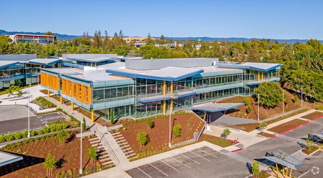
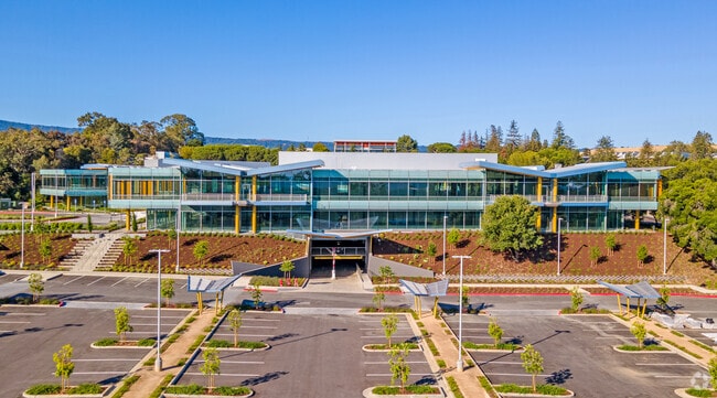
Property Record
3203 Hanover St, Palo Alto, CA 94304

NEARBY LISTINGS FOR SALE OR LEASE
Property Detail
3203 Hanover St
142-17-039
Santa Clara
Financialbuilding
California
2024
10.17 AC
2025
Palo Alto
511705
South Bay/San Jose
184,972 SF
San Jose-Sunnyvale-Santa Clara, CA
DEMOGRAPHICS near 3203 Hanover St
1 Mile
3 Mile
5 Mile
2024 Total Population
13,941
137,842
273,035
2029 Population
13,559
134,288
264,486
Pop Growth 2024-2029
(2.74%)
(2.58%)
(3.13%)
Average Age
42
39
40
2024 Total Households
5,331
50,925
98,830
HH Growth 2024-2029
(2.96%)
(2.56%)
(3.11%)
Median Household Inc
$215,217
$175,349
$177,341
Avg Household Size
2.50
2.40
2.50
2024 Avg HH Vehicles
2.00
2.00
2.00
Median Home Value
$1,142,369
$1,140,848
$1,136,157
Median Year Built
1967
1970
1968
Nearby Places
Map Layers
Map Styles
 Street
 Aerial
- Restaurants
- Banks
- Shops
- Fitness
- Groceries
PUBLIC TRANSPORTATION
COMMUTER RAIL
California Avenue Caltrain Station Southbound (Limited - Caltrain (Caltrain), Local Weekday - Caltrain (Caltrain), Local Weekend - Caltrain (Caltrain))
DRIVE
WALK
Distance
California Avenue Caltrain Station Southbound (Limited - Caltrain (Caltrain), Local Weekday - Caltrain (Caltrain), Local Weekend - Caltrain (Caltrain))
5 min
1.6 mi
California Avenue (Caltrain - Caltrain (Caltrain))
DRIVE
WALK
Distance
California Avenue (Caltrain - Caltrain (Caltrain))
5 min
2.0 mi
AIRPORT
Norman Y Mineta San Jose International
DRIVE
WALK
Distance
Norman Y Mineta San Jose International
24 min
15.8 mi
San Francisco International
DRIVE
WALK
Distance
San Francisco International
34 min
23.6 mi
Metro Oakland International
DRIVE
WALK
Distance
Metro Oakland International
47 min
32.4 mi
Freight Ports
Port of Redwood City
DRIVE
WALK
Distance
Port of Redwood City
19 min
10.5 mi
SALE & LEASE HISTORY
LISTING DATE
SALE/LEASE

Sep 17, 2022
For Lease
May 15, 2020
For Lease
Aug 08, 2022
For Lease
Nearby Properties
Address
Land Use
TOTAL SIZE
Lot Size
Zoning
Address
Land Use
TOTAL SIZE
Lot Size
Zoning
450,575 SF
3.73 AC
P(9)
Address
Land Use
TOTAL SIZE
Lot Size
Zoning
1,395,540 SF
51.72 AC
C3
Address
Land Use
TOTAL SIZE
Lot Size
Zoning
78,277 SF
16.31 AC
RP
Address
Land Use
TOTAL SIZE
Lot Size
Zoning
265,341 SF
13.53 AC
RP
Address
Land Use
TOTAL SIZE
Lot Size
Zoning
918,926 SF
17.54 AC
PC442
Address
Land Use
TOTAL SIZE
Lot Size
Zoning
584,389 SF
5.25 AC
P(40)
Address
Land Use
TOTAL SIZE
Lot Size
Zoning
675,100 SF
52.78 AC
RP5
Address
Land Use
TOTAL SIZE
Lot Size
Zoning
233,124 SF
9.18 AC
P(7)
Address
Land Use
TOTAL SIZE
Lot Size
Zoning
4.13 AC
P39
Address
Land Use
TOTAL SIZE
Lot Size
Zoning
458,842 SF
26.64 AC
RP5
Address
Land Use
TOTAL SIZE
Lot Size
Zoning
372,859 SF
4.71 AC
P
Address
Land Use
TOTAL SIZE
Lot Size
Zoning
521,754 SF
46.72 AC
RP
Address
Land Use
TOTAL SIZE
Lot Size
Zoning
322,264 SF
3.92 AC
P
Address
Land Use
TOTAL SIZE
Lot Size
Zoning
89,237 SF
5.51 AC
P(9)
Address
Land Use
TOTAL SIZE
Lot Size
Zoning
652,964 SF
14.99 AC
GM
Address
Land Use
TOTAL SIZE
Lot Size
Zoning
516,963 SF
36.46 AC
RP
Address
Land Use
TOTAL SIZE
Lot Size
Zoning
224,086 SF
10.80 AC
R3-1.
Address
Land Use
TOTAL SIZE
Lot Size
Zoning
113,964 SF
6.28 AC
RP
Address
Land Use
TOTAL SIZE
Lot Size
Zoning
184,142 SF
10.29 AC
RP
Address
Land Use
TOTAL SIZE
Lot Size
Zoning
129,678 SF
7.17 AC
LMS
Address
Land Use
TOTAL SIZE
Lot Size
Zoning
35,926 SF
6.50 AC
RP5
Address
Land Use
TOTAL SIZE
Lot Size
Zoning
128,051 SF
4.26 AC
P39
Address
Land Use
TOTAL SIZE
Lot Size
Zoning
161,432 SF
13.72 AC
RP
Address
Land Use
TOTAL SIZE
Lot Size
Zoning
224,852 SF
9.86 AC
GMB
Address
Land Use
TOTAL SIZE
Lot Size
Zoning
227,390 SF
2.28 AC
P(38)
Address
Land Use
TOTAL SIZE
Lot Size
Zoning
207,857 SF
16.34 AC
RP-5D
Address
Land Use
TOTAL SIZE
Lot Size
Zoning
97,203 SF
5.91 AC
RP
Address
Land Use
TOTAL SIZE
Lot Size
Zoning
299,882 SF
2.62 AC
P38
Address
Land Use
TOTAL SIZE
Lot Size
Zoning
8,400 SF
3.46 AC
P(7)
The World's #1 Commercial Real Estate Marketplace
Connect with us
© 2025 CoStar Group
The information above has been obtained from sources believed reliable. While we do not doubt its accuracy we have not verified it and make no guarantee, warranty or representation about it. It is your responsibility to independently confirm its accuracy and completeness. Any projections, opinions, assumptions, or estimates used are for example only and do not represent the current or future performance of the property. The value of this transaction to you depends on tax and other factors which should be evaluated by your tax, financial, and legal advisors. You and your advisors should conduct a careful, independent investigation of the property to determine to your satisfaction the suitability of the property for your needs.