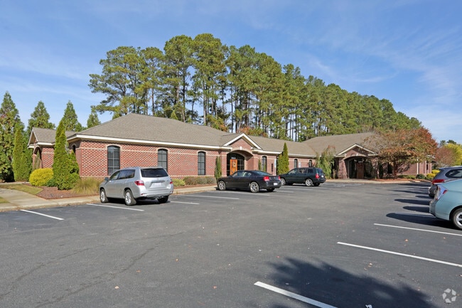
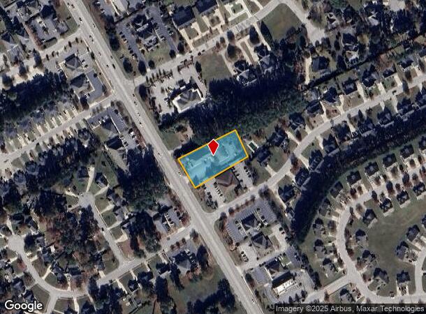
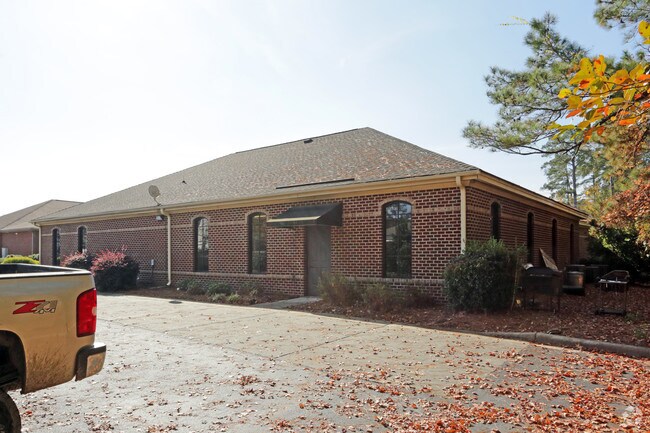
Property Record
3204 Nash St N, Wilson, NC 27896
NEARBY LISTINGS FOR SALE OR LEASE
Property Detail
3204 Nash St N
Wilson, NC
Revised Final Whitehall S
3713-55-2721.000
3204 NASH ST N L1PH1 WHITEHALL 1.00LT 01 FROM 3713764167
Officebuilding
Wilson
X
North Carolina
3720371300K
1
2024
0.91 AC
2025
Rocky Mount/Wilson
000602
Other Market Areas
8,112 SF
DEMOGRAPHICS near 3204 Nash St N
1 Mile
3 Mile
5 Mile
2024 Total Population
7,650
31,334
54,033
2029 Population
7,709
31,346
54,412
Pop Growth 2024-2029
+ 0.77%
+ 0.04%
+ 0.70%
Average Age
41
41
41
2024 Total Households
3,273
13,221
22,491
HH Growth 2024-2029
+ 0.79%
+ 0.02%
+ 0.67%
Median Household Inc
$58,545
$55,460
$48,211
Avg Household Size
2.30
2.30
2.30
2024 Avg HH Vehicles
2.00
2.00
2.00
Median Home Value
$181,795
$173,430
$155,052
Median Year Built
1994
1986
1984
Nearby Places
Map Layers
Map Styles
 Street
 Aerial
- Restaurants
- Banks
- Shops
- Fitness
- Groceries
PUBLIC TRANSPORTATION
COMMUTER RAIL
Wilson (Carolinian - Amtrak, Palmetto - Amtrak)
DRIVE
WALK
Distance
Wilson (Carolinian - Amtrak, Palmetto - Amtrak)
7 min
3.5 mi
Freight Ports
Port of Morehead City
DRIVE
WALK
Distance
Port of Morehead City
175 min
130.8 mi
SALE & LEASE HISTORY
LISTING DATE
SALE/LEASE

Nov 21, 2017
For Lease
Nearby Properties
Address
Land Use
TOTAL SIZE
Lot Size
Zoning
Address
Land Use
TOTAL SIZE
Lot Size
Zoning
25,554 SF
18.75 AC
RMX
Address
Land Use
TOTAL SIZE
Lot Size
Zoning
21,655 SF
34.44 AC
ICD
Address
Land Use
TOTAL SIZE
Lot Size
Zoning
14,520 SF
642.25 AC
HI
Address
Land Use
TOTAL SIZE
Lot Size
Zoning
4,803 SF
10.23 AC
RMX
Address
Land Use
TOTAL SIZE
Lot Size
Zoning
30,488 SF
49.06 AC
GR6
Address
Land Use
TOTAL SIZE
Lot Size
Zoning
185,515 SF
19.58 AC
HC
Address
Land Use
TOTAL SIZE
Lot Size
Zoning
11,664 SF
10.13 AC
HC
Address
Land Use
TOTAL SIZE
Lot Size
Zoning
78,875 SF
34.82 AC
ICD
Address
Land Use
TOTAL SIZE
Lot Size
Zoning
111,191 SF
10.64 AC
B4
Address
Land Use
TOTAL SIZE
Lot Size
Zoning
33,650 SF
35.52 AC
ICD
Address
Land Use
TOTAL SIZE
Lot Size
Zoning
133,549 SF
21.49 AC
HC
Address
Land Use
TOTAL SIZE
Lot Size
Zoning
9,611 SF
12 AC
ICD
Address
Land Use
TOTAL SIZE
Lot Size
Zoning
27,488 SF
17.21 AC
GR6
Address
Land Use
TOTAL SIZE
Lot Size
Zoning
35,406 SF
2.91 AC
GR6
Address
Land Use
TOTAL SIZE
Lot Size
Zoning
12,560 SF
11.89 AC
HC
Address
Land Use
TOTAL SIZE
Lot Size
Zoning
1,942 SF
28.23 AC
HI
Address
Land Use
TOTAL SIZE
Lot Size
Zoning
63,788 SF
16.30 AC
ICD
Address
Land Use
TOTAL SIZE
Lot Size
Zoning
12,493 SF
78.19 AC
ICD
Address
Land Use
TOTAL SIZE
Lot Size
Zoning
7,350 SF
9.09 AC
GC
Address
Land Use
TOTAL SIZE
Lot Size
Zoning
17,136 SF
9.81 AC
GC
Address
Land Use
TOTAL SIZE
Lot Size
Zoning
30,676 SF
9.09 AC
GC
Address
Land Use
TOTAL SIZE
Lot Size
Zoning
43,522 SF
28.26 AC
ICD
Address
Land Use
TOTAL SIZE
Lot Size
Zoning
9,681 SF
50 AC
ICD
Address
Land Use
TOTAL SIZE
Lot Size
Zoning
17,859 SF
8 AC
SR4
Address
Land Use
TOTAL SIZE
Lot Size
Zoning
8,800 SF
7.51 AC
GC
Address
Land Use
TOTAL SIZE
Lot Size
Zoning
6,312 SF
10.97 AC
GC
Address
Land Use
TOTAL SIZE
Lot Size
Zoning
35,448 SF
5.71 AC
GC
Address
Land Use
TOTAL SIZE
Lot Size
Zoning
71,781 SF
26.09 AC
HC
Address
Land Use
TOTAL SIZE
Lot Size
Zoning
49,356 SF
2.48 AC
GC
Address
Land Use
TOTAL SIZE
Lot Size
Zoning
7,301 SF
6.97 AC
GC
The World's #1 Commercial Real Estate Marketplace
Connect with us
© 2025 CoStar Group
The information above has been obtained from sources believed reliable. While we do not doubt its accuracy we have not verified it and make no guarantee, warranty or representation about it. It is your responsibility to independently confirm its accuracy and completeness. Any projections, opinions, assumptions, or estimates used are for example only and do not represent the current or future performance of the property. The value of this transaction to you depends on tax and other factors which should be evaluated by your tax, financial, and legal advisors. You and your advisors should conduct a careful, independent investigation of the property to determine to your satisfaction the suitability of the property for your needs.