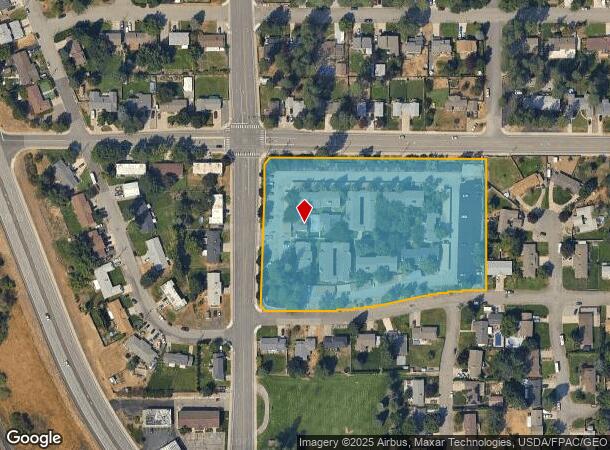
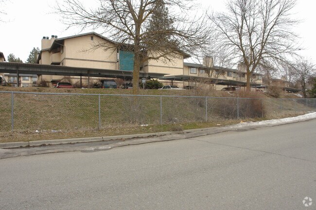
Property Record
3205 S University Rd, Spokane Valley, WA 99206

NEARBY LISTINGS FOR SALE OR LEASE
Property Detail
3205 S University Rd
Spokane-Spokane Valley, WA
Castle Add
45332.1001
CASTLE ADD LT 1 BLK 1 EXC CO RD
Apartment
Spokane
X
Washington
53063C0569D
1
2025
5.19 AC
2025
Chester
012402
Spokane
58,647 SF
DEMOGRAPHICS near 3205 S University Rd
1 Mile
3 Mile
5 Mile
2024 Total Population
8,330
54,831
133,316
2029 Population
8,838
58,227
142,216
Pop Growth 2024-2029
+ 6.10%
+ 6.19%
+ 6.68%
Average Age
42
41
40
2024 Total Households
3,129
21,336
53,145
HH Growth 2024-2029
+ 6.30%
+ 6.36%
+ 6.83%
Median Household Inc
$84,993
$69,390
$68,109
Avg Household Size
2.60
2.50
2.40
2024 Avg HH Vehicles
2.00
2.00
2.00
Median Home Value
$366,291
$341,150
$348,260
Median Year Built
1975
1975
1980
Nearby Places
Map Layers
Map Styles
 Street
 Aerial
- Restaurants
- Banks
- Shops
- Fitness
- Groceries
PUBLIC TRANSPORTATION
COMMUTER RAIL
Spokane (Empire Builder - Amtrak)
DRIVE
WALK
Distance
Spokane (Empire Builder - Amtrak)
17 min
9.1 mi
AIRPORT
Spokane International
DRIVE
WALK
Distance
Spokane International
24 min
14.9 mi
Freight Ports
Port of Everett
DRIVE
WALK
Distance
Port of Everett
352 min
310.5 mi
Nearby Properties
Address
Land Use
TOTAL SIZE
Lot Size
Zoning
Address
Land Use
TOTAL SIZE
Lot Size
Zoning
473,651 SF
76.70 AC
R-2
Address
Land Use
TOTAL SIZE
Lot Size
Zoning
260,345 SF
23.70 AC
MDR
Address
Land Use
TOTAL SIZE
Lot Size
Zoning
161,130 SF
6.45 AC
GO
Address
Land Use
TOTAL SIZE
Lot Size
Zoning
240,663 SF
8.90 AC
MF-2
Address
Land Use
TOTAL SIZE
Lot Size
Zoning
84,600 SF
17.95 AC
MF-1
Address
Land Use
TOTAL SIZE
Lot Size
Zoning
100,060 SF
14.94 AC
R-3
Address
Land Use
TOTAL SIZE
Lot Size
Zoning
69,202 SF
9.99 AC
R-2
Address
Land Use
TOTAL SIZE
Lot Size
Zoning
87,848 SF
7.36 AC
MF-2
Address
Land Use
TOTAL SIZE
Lot Size
Zoning
72,443 SF
8.90 AC
R-3
Address
Land Use
TOTAL SIZE
Lot Size
Zoning
126,906 SF
20.25 AC
LDR
Address
Land Use
TOTAL SIZE
Lot Size
Zoning
70,265 SF
9.64 AC
R-2
Address
Land Use
TOTAL SIZE
Lot Size
Zoning
47,612 SF
3.38 AC
CMU
Address
Land Use
TOTAL SIZE
Lot Size
Zoning
105,659 SF
4.40 AC
MF-1
Address
Land Use
TOTAL SIZE
Lot Size
Zoning
68,600 SF
5.25 AC
MF-2
Address
Land Use
TOTAL SIZE
Lot Size
Zoning
110,078 SF
7.23 AC
MF-2
Address
Land Use
TOTAL SIZE
Lot Size
Zoning
109,016 SF
8.01 AC
MF-2
Address
Land Use
TOTAL SIZE
Lot Size
Zoning
100,035 SF
5.74 AC
CMU
Address
Land Use
TOTAL SIZE
Lot Size
Zoning
37,759 SF
17.57 AC
LDR
Address
Land Use
TOTAL SIZE
Lot Size
Zoning
26,561 SF
2.73 AC
CMU
Address
Land Use
TOTAL SIZE
Lot Size
Zoning
102,875 SF
7.44 AC
RC
Address
Land Use
TOTAL SIZE
Lot Size
Zoning
49,598 SF
8.19 AC
R-2
Address
Land Use
TOTAL SIZE
Lot Size
Zoning
106,877 SF
6.92 AC
MF-2
Address
Land Use
TOTAL SIZE
Lot Size
Zoning
61,200 SF
0.83 AC
MF-2
Address
Land Use
TOTAL SIZE
Lot Size
Zoning
46,893 SF
2.43 AC
MF-1
Address
Land Use
TOTAL SIZE
Lot Size
Zoning
83,618 SF
0.50 AC
CMU
Address
Land Use
TOTAL SIZE
Lot Size
Zoning
46,693 SF
9.13 AC
R-2
Address
Land Use
TOTAL SIZE
Lot Size
Zoning
40,010 SF
3.35 AC
MF-2
Address
Land Use
TOTAL SIZE
Lot Size
Zoning
42,227 SF
8.63 AC
RC
Address
Land Use
TOTAL SIZE
Lot Size
Zoning
182,486 SF
23.66 AC
R-3
The World's #1 Commercial Real Estate Marketplace
Connect with us
© 2026 CoStar Group
The information above has been obtained from sources believed reliable. While we do not doubt its accuracy we have not verified it and make no guarantee, warranty or representation about it. It is your responsibility to independently confirm its accuracy and completeness. Any projections, opinions, assumptions, or estimates used are for example only and do not represent the current or future performance of the property. The value of this transaction to you depends on tax and other factors which should be evaluated by your tax, financial, and legal advisors. You and your advisors should conduct a careful, independent investigation of the property to determine to your satisfaction the suitability of the property for your needs.