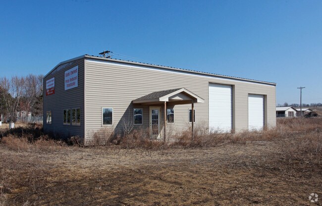
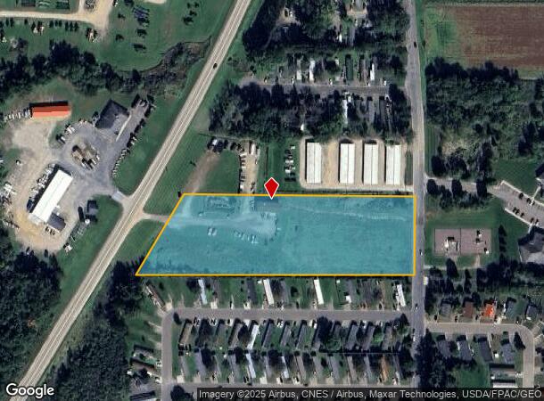
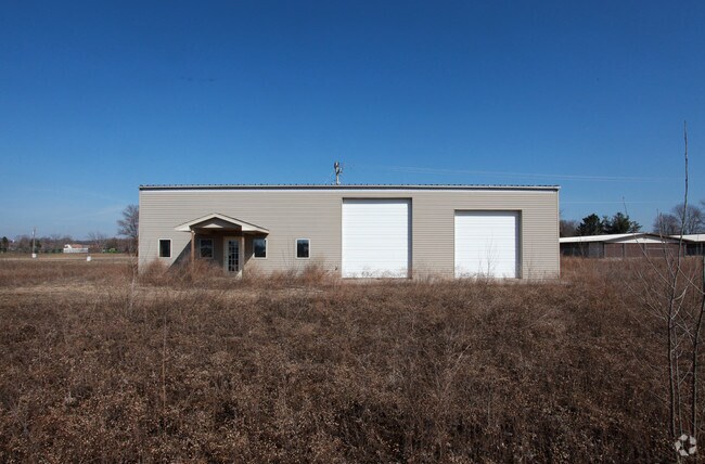
Property Record
3206 Highway 25 N, Menomonie, WI 54751
NEARBY LISTINGS FOR SALE OR LEASE
Property Detail
3206 Highway 25 N
1725122813113100004
PT NE SW
Commercialnec
Dunn
X
Wisconsin
55033C0316C
4.82 AC
2024
Eau Claire/Menomonie
2024
Other Market Areas
970801
Menomonie, WI
DEMOGRAPHICS near 3206 Highway 25 N
1 Mile
3 Mile
5 Mile
2024 Total Population
2,120
11,043
25,322
2029 Population
2,157
11,360
26,072
Pop Growth 2024-2029
+ 1.75%
+ 2.87%
+ 2.96%
Average Age
42
39
36
2024 Total Households
952
4,325
9,644
HH Growth 2024-2029
+ 1.68%
+ 3.21%
+ 3.33%
Median Household Inc
$58,213
$63,018
$59,247
Avg Household Size
2.10
2.20
2.30
2024 Avg HH Vehicles
2.00
2.00
2.00
Median Home Value
$176,764
$199,035
$200,535
Median Year Built
1993
1982
1982
Nearby Places
Map Layers
Map Styles
 Street
 Aerial
- Restaurants
- Banks
- Shops
- Fitness
- Groceries
SALE & LEASE HISTORY
LISTING DATE
SALE/LEASE

Sep 24, 2016
For Sale
Dec 05, 2019
For Lease
Nearby Properties
Address
Land Use
TOTAL SIZE
Lot Size
Zoning
Address
Land Use
TOTAL SIZE
Lot Size
Zoning
70.28 AC
I3
Address
Land Use
TOTAL SIZE
Lot Size
Zoning
20.75 AC
I1
Address
Land Use
TOTAL SIZE
Lot Size
Zoning
20.51 AC
I1
Address
Land Use
TOTAL SIZE
Lot Size
Zoning
6.17 AC
T1
Address
Land Use
TOTAL SIZE
Lot Size
Zoning
4.55 AC
B2
Address
Land Use
TOTAL SIZE
Lot Size
Zoning
1.26 AC
B1
Address
Land Use
TOTAL SIZE
Lot Size
Zoning
21.80 AC
I3
Address
Land Use
TOTAL SIZE
Lot Size
Zoning
11.61 AC
PUD
Address
Land Use
TOTAL SIZE
Lot Size
Zoning
2.24 AC
PUD
Address
Land Use
TOTAL SIZE
Lot Size
Zoning
12.65 AC
B2
Address
Land Use
TOTAL SIZE
Lot Size
Zoning
2.03 AC
B2
Address
Land Use
TOTAL SIZE
Lot Size
Zoning
4.27 AC
Address
Land Use
TOTAL SIZE
Lot Size
Zoning
6.61 AC
Address
Land Use
TOTAL SIZE
Lot Size
Zoning
0.34 AC
B1
Address
Land Use
TOTAL SIZE
Lot Size
Zoning
6.72 AC
Address
Land Use
TOTAL SIZE
Lot Size
Zoning
5.45 AC
R3
Address
Land Use
TOTAL SIZE
Lot Size
Zoning
6.80 AC
Address
Land Use
TOTAL SIZE
Lot Size
Zoning
1.60 AC
PUD
Address
Land Use
TOTAL SIZE
Lot Size
Zoning
5.54 AC
Address
Land Use
TOTAL SIZE
Lot Size
Zoning
Address
Land Use
TOTAL SIZE
Lot Size
Zoning
1.50 AC
B2
Address
Land Use
TOTAL SIZE
Lot Size
Zoning
4.34 AC
B2
Address
Land Use
TOTAL SIZE
Lot Size
Zoning
0.99 AC
B2
Address
Land Use
TOTAL SIZE
Lot Size
Zoning
5.56 AC
Address
Land Use
TOTAL SIZE
Lot Size
Zoning
5.66 AC
R3
Address
Land Use
TOTAL SIZE
Lot Size
Zoning
0.83 AC
B2
Address
Land Use
TOTAL SIZE
Lot Size
Zoning
3.37 AC
B2
Address
Land Use
TOTAL SIZE
Lot Size
Zoning
Address
Land Use
TOTAL SIZE
Lot Size
Zoning
3 AC
PUD
The World's #1 Commercial Real Estate Marketplace
Connect with us
© 2025 CoStar Group
The information above has been obtained from sources believed reliable. While we do not doubt its accuracy we have not verified it and make no guarantee, warranty or representation about it. It is your responsibility to independently confirm its accuracy and completeness. Any projections, opinions, assumptions, or estimates used are for example only and do not represent the current or future performance of the property. The value of this transaction to you depends on tax and other factors which should be evaluated by your tax, financial, and legal advisors. You and your advisors should conduct a careful, independent investigation of the property to determine to your satisfaction the suitability of the property for your needs.