Property Record
3206 Lake Trafford Rd, Immokalee, FL 34142
NEARBY LISTINGS FOR SALE OR LEASE
-
-
View all Immokalee listings for sale on LoopNet.com
Property Detail
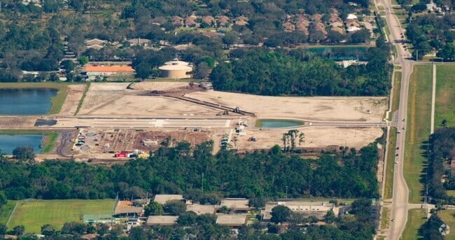
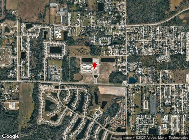
3206 Lake Trafford Rd
Naples-Immokalee-Marco Island, FL
Acreage Header
00071960001
31 46 29 S1/2 OF NE1/4, LESS R/W, LESS OR 739-675, 730-906, 621-1273, 770- 196, LESS OR 2280 PG 762, LESS OR 5917 PG 979 AND LESS OR 6414 PG 1022
Vacantlandnec
Collier
AH
Florida
12021C0140H
5
2025
61.82 AC
2025
Outlying Collier County
011306
Southwest Florida
DEMOGRAPHICS near 3206 Lake Trafford Rd
1 Mile
3 Mile
5 Mile
2024 Total Population
9,035
17,232
19,596
2029 Population
9,855
18,547
21,113
Pop Growth 2024-2029
+ 9.08%
+ 7.63%
+ 7.74%
Average Age
30
31
31
2024 Total Households
2,294
4,359
5,048
HH Growth 2024-2029
+ 8.37%
+ 6.65%
+ 6.77%
Median Household Inc
$43,628
$42,336
$41,001
Avg Household Size
3.70
3.60
3.50
2024 Avg HH Vehicles
2.00
2.00
2.00
Median Home Value
$154,343
$164,886
$166,373
Median Year Built
1994
1990
1989
Nearby Places
Map Layers
Map Styles
 Street
 Aerial
- Restaurants
- Banks
- Shops
- Fitness
- Groceries
PUBLIC TRANSPORTATION
AIRPORT
Southwest Florida International
DRIVE
WALK
Distance
Southwest Florida International
41 min
28.4 mi
Freight Ports
Port Everglades
DRIVE
WALK
Distance
Port Everglades
119 min
101.6 mi
Nearby Properties
Address
Land Use
TOTAL SIZE
Lot Size
Zoning
Address
Land Use
TOTAL SIZE
Lot Size
Zoning
217,887 SF
564.45 AC
A-MHO
Address
Land Use
TOTAL SIZE
Lot Size
Zoning
243,268 SF
43.41 AC
RSF-3
Address
Land Use
TOTAL SIZE
Lot Size
Zoning
118,281 SF
24.62 AC
A
Address
Land Use
TOTAL SIZE
Lot Size
Zoning
139,063 SF
22.83 AC
RSF-3
Address
Land Use
TOTAL SIZE
Lot Size
Zoning
182,696 SF
12.78 AC
MPUD
Address
Land Use
TOTAL SIZE
Lot Size
Zoning
39,880 SF
6.52 AC
RMF-6
Address
Land Use
TOTAL SIZE
Lot Size
Zoning
152,819 SF
17.50 AC
I-FMOSD
Address
Land Use
TOTAL SIZE
Lot Size
Zoning
336.06 AC
AOPUD
Address
Land Use
TOTAL SIZE
Lot Size
Zoning
39,087 SF
3.47 AC
C-4-MSOSD
Address
Land Use
TOTAL SIZE
Lot Size
Zoning
74,473 SF
10.29 AC
VR
Address
Land Use
TOTAL SIZE
Lot Size
Zoning
38,837 SF
9.41 AC
PUD
Address
Land Use
TOTAL SIZE
Lot Size
Zoning
40,862 SF
6.57 AC
PUD
Address
Land Use
TOTAL SIZE
Lot Size
Zoning
90,082 SF
9.37 AC
MPUD
Address
Land Use
TOTAL SIZE
Lot Size
Zoning
25,308 SF
5.96 AC
PUD
Address
Land Use
TOTAL SIZE
Lot Size
Zoning
33,530 SF
3.83 AC
PUD
Address
Land Use
TOTAL SIZE
Lot Size
Zoning
45,799 SF
8.70 AC
RMF-6
Address
Land Use
TOTAL SIZE
Lot Size
Zoning
20,484 SF
3.03 AC
C-5-AOSD
Address
Land Use
TOTAL SIZE
Lot Size
Zoning
4,719 SF
2.95 AC
C-4-MSOSD
Address
Land Use
TOTAL SIZE
Lot Size
Zoning
46,520 SF
160 AC
A
Address
Land Use
TOTAL SIZE
Lot Size
Zoning
78,445 SF
6.40 AC
RMF-16
Address
Land Use
TOTAL SIZE
Lot Size
Zoning
20,566 SF
7.42 AC
C-4-MSOSD
Address
Land Use
TOTAL SIZE
Lot Size
Zoning
27,951 SF
7.95 AC
RSF3
Address
Land Use
TOTAL SIZE
Lot Size
Zoning
93,715 SF
8.97 AC
PUD
Address
Land Use
TOTAL SIZE
Lot Size
Zoning
22,386 SF
5.66 AC
Address
Land Use
TOTAL SIZE
Lot Size
Zoning
20,525 SF
4.91 AC
C1
Address
Land Use
TOTAL SIZE
Lot Size
Zoning
28,582 SF
3.83 AC
E
Address
Land Use
TOTAL SIZE
Lot Size
Zoning
40,653 SF
5 AC
PUD
Address
Land Use
TOTAL SIZE
Lot Size
Zoning
638 AC
A-MHO
Address
Land Use
TOTAL SIZE
Lot Size
Zoning
15,048 SF
2.32 AC
C4
Address
Land Use
TOTAL SIZE
Lot Size
Zoning
107,567 SF
9.67 AC
C-5-AOSD
The World's #1 Commercial Real Estate Marketplace
Connect with us
© 2025 CoStar Group
The information above has been obtained from sources believed reliable. While we do not doubt its accuracy we have not verified it and make no guarantee, warranty or representation about it. It is your responsibility to independently confirm its accuracy and completeness. Any projections, opinions, assumptions, or estimates used are for example only and do not represent the current or future performance of the property. The value of this transaction to you depends on tax and other factors which should be evaluated by your tax, financial, and legal advisors. You and your advisors should conduct a careful, independent investigation of the property to determine to your satisfaction the suitability of the property for your needs.