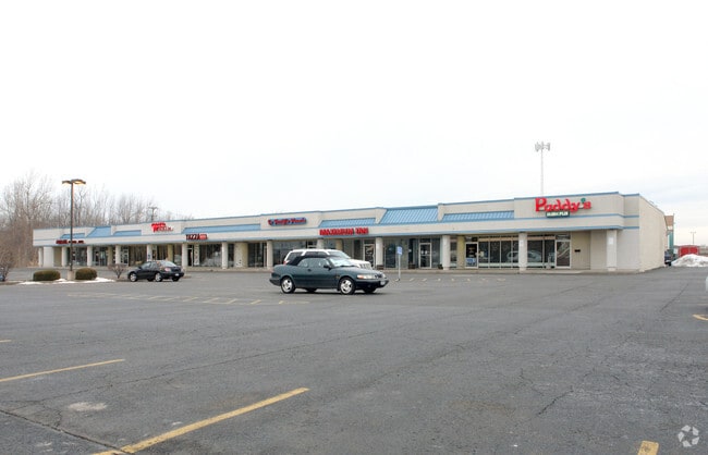
Property Record
3208 Latta Rd, Rochester, NY 14612


NEARBY LISTINGS FOR SALE OR LEASE
Property Detail
3208 Latta Rd
262800-045-030-0001-011-000
1ST DIV L28 T2
Stripcommercialcenter
Monroe
X
New York
36055C0064H
11.000
2025
4 AC
2024
Northwest
013507
Rochester
16,910 SF
Rochester, NY
DEMOGRAPHICS near 3208 Latta Rd
1 Mile
3 Mile
5 Mile
2024 Total Population
8,037
57,030
116,398
2029 Population
7,972
56,374
114,786
Pop Growth 2024-2029
(0.81%)
(1.15%)
(1.38%)
Average Age
46
44
43
2024 Total Households
3,189
23,871
50,298
HH Growth 2024-2029
(0.72%)
(1.24%)
(1.46%)
Median Household Inc
$94,241
$75,788
$66,718
Avg Household Size
2.40
2.30
2.20
2024 Avg HH Vehicles
2.00
2.00
2.00
Median Home Value
$182,528
$173,541
$158,238
Median Year Built
1985
1978
1969
Nearby Places
Map Layers
Map Styles
 Street
 Aerial
- Restaurants
- Banks
- Shops
- Fitness
- Groceries
PUBLIC TRANSPORTATION
AIRPORT
Frederick Douglass/Greater Rochester International
DRIVE
WALK
Distance
Frederick Douglass/Greater Rochester International
18 min
12.5 mi
SALE & LEASE HISTORY
LISTING DATE
SALE/LEASE

Sep 25, 2016
For Lease
Nearby Properties
Address
Land Use
TOTAL SIZE
Lot Size
Zoning
Address
Land Use
TOTAL SIZE
Lot Size
Zoning
Address
Land Use
TOTAL SIZE
Lot Size
Zoning
352,001 SF
76.90 AC
Address
Land Use
TOTAL SIZE
Lot Size
Zoning
330,700 SF
66.90 AC
Address
Land Use
TOTAL SIZE
Lot Size
Zoning
180,406 SF
28.80 AC
Address
Land Use
TOTAL SIZE
Lot Size
Zoning
65,000 SF
5.10 AC
Address
Land Use
TOTAL SIZE
Lot Size
Zoning
37,487 SF
47.63 AC
Address
Land Use
TOTAL SIZE
Lot Size
Zoning
4,728 SF
34.54 AC
03 - MULTI
Address
Land Use
TOTAL SIZE
Lot Size
Zoning
225,793 SF
32.60 AC
Address
Land Use
TOTAL SIZE
Lot Size
Zoning
227,808 SF
69.10 AC
Address
Land Use
TOTAL SIZE
Lot Size
Zoning
3,710 SF
30.20 AC
05 - COMME
Address
Land Use
TOTAL SIZE
Lot Size
Zoning
Address
Land Use
TOTAL SIZE
Lot Size
Zoning
9,360 SF
23.50 AC
05 - COMME
Address
Land Use
TOTAL SIZE
Lot Size
Zoning
14,800 SF
14.91 AC
05 - COMME
Address
Land Use
TOTAL SIZE
Lot Size
Zoning
136,148 SF
12.53 AC
Address
Land Use
TOTAL SIZE
Lot Size
Zoning
0.84 AC
Address
Land Use
TOTAL SIZE
Lot Size
Zoning
99,308 SF
6.80 AC
05 - COMME
Address
Land Use
TOTAL SIZE
Lot Size
Zoning
9,661 SF
19.62 AC
05 - COMME
Address
Land Use
TOTAL SIZE
Lot Size
Zoning
4,540 SF
14.65 AC
Address
Land Use
TOTAL SIZE
Lot Size
Zoning
108,401 SF
67.82 AC
05 - COMME
Address
Land Use
TOTAL SIZE
Lot Size
Zoning
Address
Land Use
TOTAL SIZE
Lot Size
Zoning
7,120 SF
23.10 AC
Address
Land Use
TOTAL SIZE
Lot Size
Zoning
Address
Land Use
TOTAL SIZE
Lot Size
Zoning
78,957 SF
90.80 AC
02 - SINGL
Address
Land Use
TOTAL SIZE
Lot Size
Zoning
14,080 SF
15.20 AC
05 - COMME
Address
Land Use
TOTAL SIZE
Lot Size
Zoning
2,572 SF
26.40 AC
Address
Land Use
TOTAL SIZE
Lot Size
Zoning
93,865 SF
62.80 AC
Address
Land Use
TOTAL SIZE
Lot Size
Zoning
12,100 SF
15.63 AC
05 - COMME
Address
Land Use
TOTAL SIZE
Lot Size
Zoning
76,739 SF
12.79 AC
Address
Land Use
TOTAL SIZE
Lot Size
Zoning
56,856 SF
15 AC
Address
Land Use
TOTAL SIZE
Lot Size
Zoning
3,472 SF
19.60 AC
05 - COMME
The World's #1 Commercial Real Estate Marketplace
Connect with us
© 2026 CoStar Group
The information above has been obtained from sources believed reliable. While we do not doubt its accuracy we have not verified it and make no guarantee, warranty or representation about it. It is your responsibility to independently confirm its accuracy and completeness. Any projections, opinions, assumptions, or estimates used are for example only and do not represent the current or future performance of the property. The value of this transaction to you depends on tax and other factors which should be evaluated by your tax, financial, and legal advisors. You and your advisors should conduct a careful, independent investigation of the property to determine to your satisfaction the suitability of the property for your needs.