Property Record
3209 Secrest Shortcut Rd, Monroe, NC 28110
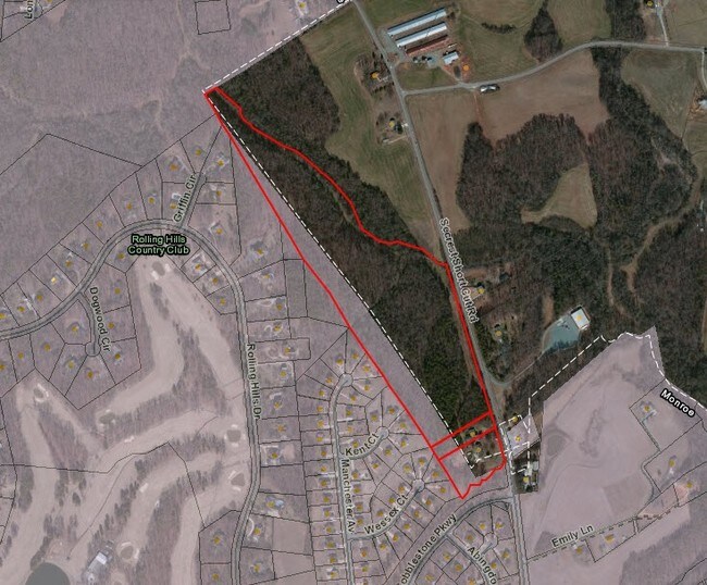

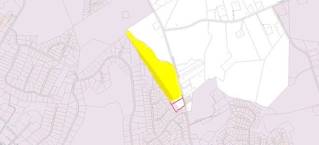
Property Detail
3209 Secrest Shortcut Rd
09-256-004
#1 OPCQ019
Realpropertynec
Union
RA-40 UNIO
North Carolina
AE The base floodplain where base flood elevations are provided. AE Zones are now used on new format FIRMs instead of A1-A30 Zones.
1.35 AC
2025
Union County
2025
Charlotte
020401
Charlotte-Concord-Gastonia, NC-SC
NEARBY LISTINGS FOR SALE OR LEASE
DEMOGRAPHICS near 3209 Secrest Shortcut Rd
1 mile
3 mile
5 mile
2025 Total Population
2,952
21,808
67,783
2030 Population
3,313
24,144
74,424
Pop Growth 2025-2030
+ 12.23%
+ 10.71%
+ 9.80%
Average Age
43
39
38
2025 Total Households
1,094
7,955
23,599
HH Growth 2025-2030
+ 12.34%
+ 10.77%
+ 9.87%
Median Household Inc
$93,530
$68,677
$77,410
Avg Household Size
2.60
2.70
2.80
2025 Avg HH Vehicles
3.00
2.00
2.00
Median Home Value
$528,985
$351,933
$352,545
Median Year Built
1999
1995
1996
Nearby Places
Map Layers
Map Styles
 Street
 Aerial
Layers
 Traffic
 Biking
Places
Listings with unknown addresses are not visible on the map
- Restaurants
- Banks
- Shops
- Fitness
- Groceries
PUBLIC TRANSPORTATION
AIRPORT
Charlotte/Douglas International
Drive
Walk
Distance
Charlotte/Douglas International
47 min
31.0 mi
Concord-Padgett Regional
Drive
Walk
Distance
Concord-Padgett Regional
43 min
31.4 mi
Freight Ports
North Charleston Terminal
Drive
Walk
Distance
North Charleston Terminal
226 min
187.8 mi
SALE & LEASE HISTORY
LISTING DATE
SALE/LEASE

Sep 24, 2016
For Sale
Dec 28, 2017
For Sale
Nearby Properties
Address
Land Use
TOTAL SIZE
Lot Size
Zoning
Address
Land Use
TOTAL SIZE
Lot Size
Zoning
82.26 AC
G-I MONROE
Address
Land Use
TOTAL SIZE
Lot Size
Zoning
148,145 SF
26.68 AC
G-I MONROE
Address
Land Use
TOTAL SIZE
Lot Size
Zoning
78.48 AC
Address
Land Use
TOTAL SIZE
Lot Size
Zoning
30,708 SF
29.10 AC
R-MF MONRO
Address
Land Use
TOTAL SIZE
Lot Size
Zoning
150,880 SF
73.40 AC
G-I MONROE
Address
Land Use
TOTAL SIZE
Lot Size
Zoning
18,208 SF
12.09 AC
R-MF MONRO
Address
Land Use
TOTAL SIZE
Lot Size
Zoning
57,664 SF
45.15 AC
R-20 MONRO
Address
Land Use
TOTAL SIZE
Lot Size
Zoning
81,504 SF
30.21 AC
CD MONROE
Address
Land Use
TOTAL SIZE
Lot Size
Zoning
11,424 SF
17.71 AC
GB MONROE
Address
Land Use
TOTAL SIZE
Lot Size
Zoning
24.89 AC
Address
Land Use
TOTAL SIZE
Lot Size
Zoning
219,625 SF
36.12 AC
GB MONROE
Address
Land Use
TOTAL SIZE
Lot Size
Zoning
54,712 SF
10.01 AC
GB MONROE
Address
Land Use
TOTAL SIZE
Lot Size
Zoning
123,296 SF
9.70 AC
CD MONROE
Address
Land Use
TOTAL SIZE
Lot Size
Zoning
5.89 AC
G-I MONROE
Address
Land Use
TOTAL SIZE
Lot Size
Zoning
40,291 SF
3.59 AC
CD MONROE
Address
Land Use
TOTAL SIZE
Lot Size
Zoning
7,680 SF
9.99 AC
R-MF MONRO
Address
Land Use
TOTAL SIZE
Lot Size
Zoning
14.77 AC
Address
Land Use
TOTAL SIZE
Lot Size
Zoning
6,440 SF
2.23 AC
GB MONROE
Address
Land Use
TOTAL SIZE
Lot Size
Zoning
101,035 SF
26.11 AC
G-I MONROE
Address
Land Use
TOTAL SIZE
Lot Size
Zoning
9,072 SF
15.23 AC
R-MF MONRO
Address
Land Use
TOTAL SIZE
Lot Size
Zoning
59,060 SF
7.51 AC
CD MONROE
Address
Land Use
TOTAL SIZE
Lot Size
Zoning
9.57 AC
Address
Land Use
TOTAL SIZE
Lot Size
Zoning
65,515 SF
27.66 AC
G-I MONROE
Address
Land Use
TOTAL SIZE
Lot Size
Zoning
63,813 SF
1.95 AC
GB MONROE
Address
Land Use
TOTAL SIZE
Lot Size
Zoning
62,865 SF
4.87 AC
CD MONROE
Address
Land Use
TOTAL SIZE
Lot Size
Zoning
32,872 SF
9.35 AC
Address
Land Use
TOTAL SIZE
Lot Size
Zoning
136,370 SF
10.22 AC
GB MONROE
Address
Land Use
TOTAL SIZE
Lot Size
Zoning
26.83 AC
CD MONROE
Address
Land Use
TOTAL SIZE
Lot Size
Zoning
41,820 SF
6.23 AC
G-I MONROE
Address
Land Use
TOTAL SIZE
Lot Size
Zoning
22,944 SF
11.33 AC
GB MONROE
The World's #1 Commercial Real Estate Marketplace
Connect with us
© 2026 CoStar Group
The information above has been obtained from sources believed reliable. While we do not doubt its accuracy we have not verified it and make no guarantee, warranty or representation about it. It is your responsibility to independently confirm its accuracy and completeness. Any projections, opinions, assumptions, or estimates used are for example only and do not represent the current or future performance of the property. The value of this transaction to you depends on tax and other factors which should be evaluated by your tax, financial, and legal advisors. You and your advisors should conduct a careful, independent investigation of the property to determine to your satisfaction the suitability of the property for your needs.