Property Record
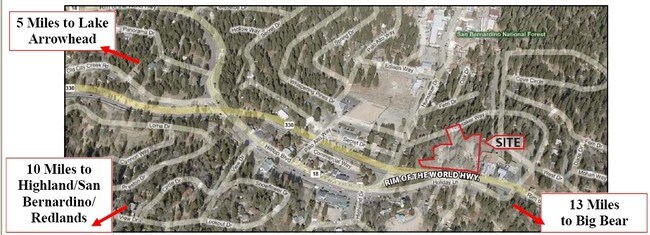
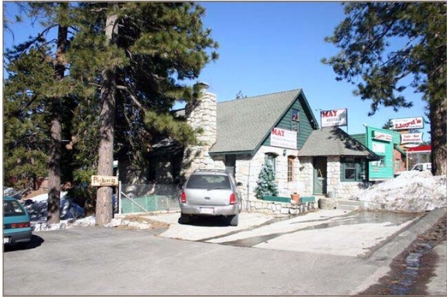
32098 Highway 18, Running Springs, CA 92382

NEARBY LISTINGS FOR SALE OR LEASE
-
-
View all Running Springs listings for sale on LoopNet.com
Property Detail
32098 Highway 18
0295-143-01
Running Springs Park
Officebuilding
TR NO 1847 RUNNING SPRINGS PTN BLK 5 DESC AS COM AT SE COR SD BLK 5 TH N 0 DEG 41 MIN W ALG E LI SD TR 313.13 FT TH S 78 DEG O0 MIN W 56.66 FT TH S 49 DEG 00 MIN W 160 FT TH S 84 DEG 33 MIN W 86.02 FT TH S 15 DEG 25 MIN E 95.44 FT TO PT ON
D
San Bernardino
06071C8000H
California
2024
0.15 AC
2025
Redlands/Loma Linda
011101
Inland Empire (California)
1,253 SF
Riverside-San Bernardino-Ontario, CA
DEMOGRAPHICS near 32098 Highway 18
1 Mile
3 Mile
5 Mile
2024 Total Population
2,282
5,133
6,631
2029 Population
2,246
5,055
6,545
Pop Growth 2024-2029
(1.58%)
(1.52%)
(1.30%)
Average Age
42
43
43
2024 Total Households
962
2,189
2,786
HH Growth 2024-2029
(1.66%)
(1.60%)
(1.36%)
Median Household Inc
$78,486
$81,281
$76,722
Avg Household Size
2.30
2.30
2.30
2024 Avg HH Vehicles
2.00
2.00
2.00
Median Home Value
$387,831
$359,328
$364,176
Median Year Built
1971
1971
1971
Nearby Places
Map Layers
Map Styles
 Street
 Aerial
- Restaurants
- Banks
- Shops
- Fitness
- Groceries
Nearby Properties
Address
Land Use
TOTAL SIZE
Lot Size
Zoning
Address
Land Use
TOTAL SIZE
Lot Size
Zoning
326,834 SF
38.56 AC
HTRC
Address
Land Use
TOTAL SIZE
Lot Size
Zoning
52,483 SF
25 AC
HTSDRES
Address
Land Use
TOTAL SIZE
Lot Size
Zoning
992 SF
80 AC
HTRC
Address
Land Use
TOTAL SIZE
Lot Size
Zoning
3,615 SF
21.73 AC
HTSDRES
Address
Land Use
TOTAL SIZE
Lot Size
Zoning
3,534 SF
0.70 AC
HTIC
Address
Land Use
TOTAL SIZE
Lot Size
Zoning
114.72 AC
HTRC
Address
Land Use
TOTAL SIZE
Lot Size
Zoning
2,894 SF
57.84 AC
HTRC
Address
Land Use
TOTAL SIZE
Lot Size
Zoning
9,328 SF
0.40 AC
HTCGSCP
Address
Land Use
TOTAL SIZE
Lot Size
Zoning
3,196 SF
160 AC
Address
Land Use
TOTAL SIZE
Lot Size
Zoning
4,275 SF
0.36 AC
HTCGSCP
Address
Land Use
TOTAL SIZE
Lot Size
Zoning
19,256 SF
11.06 AC
HTRC
Address
Land Use
TOTAL SIZE
Lot Size
Zoning
4,664 SF
5.88 AC
HTCGSCP
Address
Land Use
TOTAL SIZE
Lot Size
Zoning
18,796 SF
11.88 AC
HTRC
Address
Land Use
TOTAL SIZE
Lot Size
Zoning
5,108 SF
0.21 AC
HTCGSCP
Address
Land Use
TOTAL SIZE
Lot Size
Zoning
7,144 SF
0.75 AC
HTCGSCP
Address
Land Use
TOTAL SIZE
Lot Size
Zoning
5,400 SF
0.59 AC
HTCGSCP
Address
Land Use
TOTAL SIZE
Lot Size
Zoning
126.07 AC
HTSDRES
Address
Land Use
TOTAL SIZE
Lot Size
Zoning
5,483 SF
9.17 AC
HTIC
Address
Land Use
TOTAL SIZE
Lot Size
Zoning
160.37 AC
HTRC
Address
Land Use
TOTAL SIZE
Lot Size
Zoning
4,307 SF
1.68 AC
HTCGSCP
Address
Land Use
TOTAL SIZE
Lot Size
Zoning
4,752 SF
0.33 AC
HTCO
Address
Land Use
TOTAL SIZE
Lot Size
Zoning
3,029 SF
0.93 AC
HTCGSCP
Address
Land Use
TOTAL SIZE
Lot Size
Zoning
40.25 AC
HTSDRES
Address
Land Use
TOTAL SIZE
Lot Size
Zoning
4,617 SF
0.34 AC
HTCGSCP
Address
Land Use
TOTAL SIZE
Lot Size
Zoning
4,340 SF
0.57 AC
HTCGSCP
Address
Land Use
TOTAL SIZE
Lot Size
Zoning
12,082 SF
0.83 AC
HTCGSCP
Address
Land Use
TOTAL SIZE
Lot Size
Zoning
7,585 SF
2.39 AC
HTCGSCP
Address
Land Use
TOTAL SIZE
Lot Size
Zoning
3,000 SF
1.07 AC
HTIC
Address
Land Use
TOTAL SIZE
Lot Size
Zoning
8.63 AC
HTRC
Address
Land Use
TOTAL SIZE
Lot Size
Zoning
67.98 AC
HTSDRES
The World's #1 Commercial Real Estate Marketplace
Connect with us
© 2025 CoStar Group
The information above has been obtained from sources believed reliable. While we do not doubt its accuracy we have not verified it and make no guarantee, warranty or representation about it. It is your responsibility to independently confirm its accuracy and completeness. Any projections, opinions, assumptions, or estimates used are for example only and do not represent the current or future performance of the property. The value of this transaction to you depends on tax and other factors which should be evaluated by your tax, financial, and legal advisors. You and your advisors should conduct a careful, independent investigation of the property to determine to your satisfaction the suitability of the property for your needs.