Property Record
321 16Th St, Toledo, OH 43604
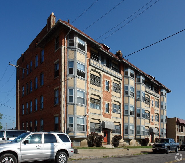

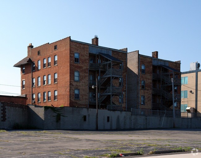
Property Detail
321 16Th St
Toledo, OH
PHILLIPS ADDITION PT LOT 12 & HUNTS ADDN PT LOTS 78 & 79& 80...SW 114 FT SE
12-09274
LUCAS
Commercialacreage
Ohio
10-IL
12
B and X Area of moderate flood hazard, usually the area between the limits of the 100-year and 500-year floods.
0.26 AC
0
Downtown Toledo
2025
Toledo
002700
NEARBY LISTINGS FOR SALE OR LEASE
DEMOGRAPHICS near 321 16Th St
1 mile
3 mile
5 mile
2025 Total Population
13,491
104,656
217,510
2030 Population
13,788
106,747
218,113
Pop Growth 2025-2030
+ 2.20%
+ 2.00%
+ 0.28%
Average Age
38
38
38
2025 Total Households
6,714
43,409
91,373
HH Growth 2025-2030
+ 2.16%
+ 1.93%
+ 0.25%
Median Household Inc
$20,255
$36,404
$46,451
Avg Household Size
1.80
2.30
2.20
2025 Avg HH Vehicles
1.00
1.00
2.00
Median Home Value
$87,970
$63,892
$97,643
Median Year Built
1949
1947
1951
Nearby Places
Map Layers
Map Styles
 Street
 Aerial
Transit
 Traffic
 Biking
Places
Listings with unknown addresses are not visible on the map
- Restaurants
- Banks
- Shops
- Fitness
- Groceries
PUBLIC TRANSPORTATION
COMMUTER RAIL
Drive
Walk
Distance
5 min
2.0 mi
AIRPORT
Eugene F Kranz Toledo Express
Drive
Walk
Distance
Eugene F Kranz Toledo Express
34 min
19.4 mi
Freight Ports
Drive
Walk
Distance
15 min
5.9 mi
Nearby Properties
Address
Land Use
TOTAL SIZE
Lot Size
Zoning
Address
Land Use
TOTAL SIZE
Lot Size
Zoning
3,101,694 SF
35.64 AC
10-IC
Address
Land Use
TOTAL SIZE
Lot Size
Zoning
1,243,593 SF
42.25 AC
10-MX
Address
Land Use
TOTAL SIZE
Lot Size
Zoning
1,046,727 SF
0.41 AC
10-IC
Address
Land Use
TOTAL SIZE
Lot Size
Zoning
569,999 SF
45.25 AC
10-MX
Address
Land Use
TOTAL SIZE
Lot Size
Zoning
277,862 SF
3 AC
10-CD
Address
Land Use
TOTAL SIZE
Lot Size
Zoning
314,826 SF
10.28 AC
10-CM
Address
Land Use
TOTAL SIZE
Lot Size
Zoning
323,421 SF
134.98 AC
10-IC
Address
Land Use
TOTAL SIZE
Lot Size
Zoning
625,485 SF
2 AC
10-MX
Address
Land Use
TOTAL SIZE
Lot Size
Zoning
111,471 SF
6.17 AC
10-CD
Address
Land Use
TOTAL SIZE
Lot Size
Zoning
171,946 SF
0.17 AC
10-IC
Address
Land Use
TOTAL SIZE
Lot Size
Zoning
Address
Land Use
TOTAL SIZE
Lot Size
Zoning
328,568 SF
16.37 AC
10-CO
Address
Land Use
TOTAL SIZE
Lot Size
Zoning
243,165 SF
3.63 AC
10-CD
Address
Land Use
TOTAL SIZE
Lot Size
Zoning
1.74 AC
10-CD
Address
Land Use
TOTAL SIZE
Lot Size
Zoning
296,348 SF
1 AC
10-CO
Address
Land Use
TOTAL SIZE
Lot Size
Zoning
375,323 SF
10-IC
Address
Land Use
TOTAL SIZE
Lot Size
Zoning
182,983 SF
2 AC
10-CD
Address
Land Use
TOTAL SIZE
Lot Size
Zoning
14,824 SF
54.18 AC
10-MX
Address
Land Use
TOTAL SIZE
Lot Size
Zoning
317,139 SF
25.80 AC
10-IC
Address
Land Use
TOTAL SIZE
Lot Size
Zoning
68,517 SF
1.56 AC
10-RM36
Address
Land Use
TOTAL SIZE
Lot Size
Zoning
172,044 SF
12.78 AC
10-MX
Address
Land Use
TOTAL SIZE
Lot Size
Zoning
390,272 SF
5 AC
10-CD
Address
Land Use
TOTAL SIZE
Lot Size
Zoning
228,692 SF
10.45 AC
10-RM36
Address
Land Use
TOTAL SIZE
Lot Size
Zoning
202,118 SF
1.50 AC
10-CD
Address
Land Use
TOTAL SIZE
Lot Size
Zoning
232,758 SF
2 AC
10-CO
Address
Land Use
TOTAL SIZE
Lot Size
Zoning
297,666 SF
4 AC
10-CO
Address
Land Use
TOTAL SIZE
Lot Size
Zoning
132,690 SF
5 AC
10-CO
Address
Land Use
TOTAL SIZE
Lot Size
Zoning
77,274 SF
4 AC
10-CO
Address
Land Use
TOTAL SIZE
Lot Size
Zoning
158,288 SF
1.22 AC
10-CO
Address
Land Use
TOTAL SIZE
Lot Size
Zoning
370,650 SF
13.65 AC
10-MX
The World's #1 Commercial Real Estate Marketplace
Connect with us
© 2026 CoStar Group
The information above has been obtained from sources believed reliable. While we do not doubt its accuracy we have not verified it and make no guarantee, warranty or representation about it. It is your responsibility to independently confirm its accuracy and completeness. Any projections, opinions, assumptions, or estimates used are for example only and do not represent the current or future performance of the property. The value of this transaction to you depends on tax and other factors which should be evaluated by your tax, financial, and legal advisors. You and your advisors should conduct a careful, independent investigation of the property to determine to your satisfaction the suitability of the property for your needs.