Property Record
321 Bercut Dr, Sacramento, CA 95811


NEARBY LISTINGS FOR SALE OR LEASE
-
-
View all Sacramento listings for sale on LoopNet.com
Property Detail
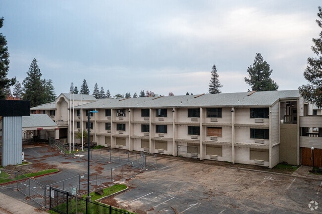
321 Bercut Dr
Sacramento--Roseville--Arden-Arcade, CA
Parcel Map
001-0182-024
PARCEL MAP, LOT B
Apartment
Sacramento
X
California
06067C0157J
b
2024
3.56 AC
2025
Sacramento CBD
005301
Sacramento
131,352 SF
DEMOGRAPHICS near 321 Bercut Dr
1 Mile
3 Mile
5 Mile
2024 Total Population
7,837
153,402
338,613
2029 Population
8,025
155,668
342,770
Pop Growth 2024-2029
+ 2.40%
+ 1.48%
+ 1.23%
Average Age
36
38
38
2024 Total Households
3,032
62,576
132,020
HH Growth 2024-2029
+ 2.80%
+ 1.72%
+ 1.36%
Median Household Inc
$47,951
$68,690
$74,752
Avg Household Size
2.20
2.20
2.40
2024 Avg HH Vehicles
1.00
2.00
2.00
Median Home Value
$384,561
$442,448
$480,284
Median Year Built
1989
1975
1974
Nearby Places
Map Layers
Map Styles
 Street
 Aerial
- Restaurants
- Banks
- Shops
- Fitness
- Groceries
PUBLIC TRANSPORTATION
TRANSIT/SUBWAY
Township 9 Station (Wb) (13th - Richards/Township 9 - Sacramento Regional Transit)
DRIVE
WALK
Distance
Township 9 Station (Wb) (13th - Richards/Township 9 - Sacramento Regional Transit)
1 min
15 min
0.6 mi
Township 9 Station (Wb) (13th - Richards/Township 9 - Sacramento Regional Transit)
DRIVE
WALK
Distance
Township 9 Station (Wb) (13th - Richards/Township 9 - Sacramento Regional Transit)
1 min
13 min
0.7 mi
COMMUTER RAIL
Sacramento (Capitol Corridor - Capitol Corridor Joint Powers Authority)
DRIVE
WALK
Distance
Sacramento (Capitol Corridor - Capitol Corridor Joint Powers Authority)
3 min
1.6 mi
AIRPORT
Sacramento International
DRIVE
WALK
Distance
Sacramento International
15 min
9.8 mi
Freight Ports
Port of Stockton
DRIVE
WALK
Distance
Port of Stockton
55 min
47.5 mi
SALE & LEASE HISTORY
LISTING DATE
SALE/LEASE

Sep 24, 2016
For Sale
Nearby Properties
Address
Land Use
TOTAL SIZE
Lot Size
Zoning
Address
Land Use
TOTAL SIZE
Lot Size
Zoning
1,095,507 SF
1.39 AC
H-SPD C-2-
Address
Land Use
TOTAL SIZE
Lot Size
Zoning
5.64 AC
C-3-SPD
Address
Land Use
TOTAL SIZE
Lot Size
Zoning
487,483 SF
1.12 AC
C-3-SPD
Address
Land Use
TOTAL SIZE
Lot Size
Zoning
756,831 SF
1.39 AC
C-2-SPD
Address
Land Use
TOTAL SIZE
Lot Size
Zoning
399,626 SF
2.41 AC
C-3-SPD
Address
Land Use
TOTAL SIZE
Lot Size
Zoning
366,730 SF
0.89 AC
C-3-SPD
Address
Land Use
TOTAL SIZE
Lot Size
Zoning
200,616 SF
2.54 AC
C-2-SPD
Address
Land Use
TOTAL SIZE
Lot Size
Zoning
594,942 SF
2.39 AC
C-3-SPD
Address
Land Use
TOTAL SIZE
Lot Size
Zoning
676,447 SF
1.43 AC
C-3-SPD
Address
Land Use
TOTAL SIZE
Lot Size
Zoning
9.74 AC
EC-50-PUD
Address
Land Use
TOTAL SIZE
Lot Size
Zoning
193,521 SF
0.60 AC
C-3-SPD
Address
Land Use
TOTAL SIZE
Lot Size
Zoning
339,329 SF
6.40 AC
R-5-PUD-SP
Address
Land Use
TOTAL SIZE
Lot Size
Zoning
213,557 SF
2.33 AC
C-3-SPD
Address
Land Use
TOTAL SIZE
Lot Size
Zoning
0.65 AC
C-4-SPD
Address
Land Use
TOTAL SIZE
Lot Size
Zoning
467,970 SF
4.59 AC
W-F
Address
Land Use
TOTAL SIZE
Lot Size
Zoning
410,420 SF
0.95 AC
C-3-SPD
Address
Land Use
TOTAL SIZE
Lot Size
Zoning
318,616 SF
16.40 AC
R-2B-PUD
Address
Land Use
TOTAL SIZE
Lot Size
Zoning
R-4-PUD C-
Address
Land Use
TOTAL SIZE
Lot Size
Zoning
0.13 AC
WF
Address
Land Use
TOTAL SIZE
Lot Size
Zoning
26,712 SF
1.90 AC
R-5-PUD-SP
Address
Land Use
TOTAL SIZE
Lot Size
Zoning
26,712 SF
1.85 AC
R-5-PUD-SP
Address
Land Use
TOTAL SIZE
Lot Size
Zoning
2.88 AC
C-3-SPD
Address
Land Use
TOTAL SIZE
Lot Size
Zoning
508,916 SF
0.71 AC
C-3-SPD
Address
Land Use
TOTAL SIZE
Lot Size
Zoning
303,254 SF
10.63 AC
OB-PUD
Address
Land Use
TOTAL SIZE
Lot Size
Zoning
246,417 SF
1.19 AC
C-3-SPD
Address
Land Use
TOTAL SIZE
Lot Size
Zoning
405,074 SF
2.39 AC
C-3-SPD
Address
Land Use
TOTAL SIZE
Lot Size
Zoning
119,055 SF
1.18 AC
C-2-SPD
Address
Land Use
TOTAL SIZE
Lot Size
Zoning
383,000 SF
25.52 AC
M-1
Address
Land Use
TOTAL SIZE
Lot Size
Zoning
0.90 AC
C-3-SPD
Address
Land Use
TOTAL SIZE
Lot Size
Zoning
4.41 AC
W-F
The World's #1 Commercial Real Estate Marketplace
Connect with us
© 2025 CoStar Group
The information above has been obtained from sources believed reliable. While we do not doubt its accuracy we have not verified it and make no guarantee, warranty or representation about it. It is your responsibility to independently confirm its accuracy and completeness. Any projections, opinions, assumptions, or estimates used are for example only and do not represent the current or future performance of the property. The value of this transaction to you depends on tax and other factors which should be evaluated by your tax, financial, and legal advisors. You and your advisors should conduct a careful, independent investigation of the property to determine to your satisfaction the suitability of the property for your needs.