Property Record
321 Clear Ridge Rd, Union Bridge, MD 21791
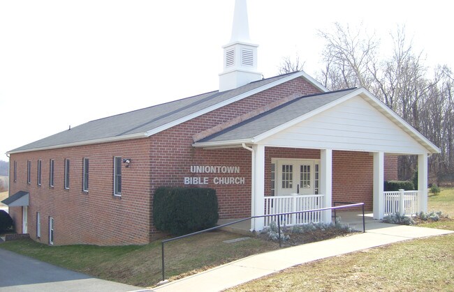


Property Detail
321 Clear Ridge Rd
02-001896
LT - 4.52 ACS SE/S CLEAR RIDGE RD/RT84 CLEAR RIDGE
Religious
Carroll
AGRIC
Maryland
B and X Area of moderate flood hazard, usually the area between the limits of the 100-year and 500-year floods.
4.52 AC
2025
Carroll County
2025
Baltimore
502000
Baltimore-Columbia-Towson, MD
3,200 SF
NEARBY LISTINGS FOR SALE OR LEASE
-
-
View all Union Bridge listings for sale on LoopNet.com
DEMOGRAPHICS near 321 Clear Ridge Rd
1 mile
3 mile
5 mile
2025 Total Population
498
4,478
14,473
2030 Population
501
4,560
14,841
Pop Growth 2025-2030
+ 0.60%
+ 1.83%
+ 2.54%
Average Age
43
42
43
2025 Total Households
185
1,717
5,655
HH Growth 2025-2030
+ 0.54%
+ 1.86%
+ 2.62%
Median Household Inc
$114,516
$101,471
$101,721
Avg Household Size
2.70
2.60
2.50
2025 Avg HH Vehicles
3.00
2.00
2.00
Median Home Value
$425,000
$385,302
$386,392
Median Year Built
1961
1958
1979
Nearby Places
Map Layers
Map Styles
 Street
 Aerial
Transit
 Traffic
 Biking
Places
Listings with unknown addresses are not visible on the map
- Restaurants
- Banks
- Shops
- Fitness
- Groceries
SALE & LEASE HISTORY
LISTING DATE
SALE/LEASE

Nov 30, 2017
For Sale
Nearby Properties
Address
Land Use
TOTAL SIZE
Lot Size
Zoning
Address
Land Use
TOTAL SIZE
Lot Size
Zoning
193,354 SF
24.18 AC
CONSE
Address
Land Use
TOTAL SIZE
Lot Size
Zoning
70,807 SF
17.33 AC
R-100
Address
Land Use
TOTAL SIZE
Lot Size
Zoning
45,602 SF
137.42 AC
I-2
Address
Land Use
TOTAL SIZE
Lot Size
Zoning
62,493 SF
30.01 AC
PUBLI
Address
Land Use
TOTAL SIZE
Lot Size
Zoning
26,856 SF
0.63 AC
PUBLI
Address
Land Use
TOTAL SIZE
Lot Size
Zoning
43,352 SF
3.25 AC
PUBLI
Address
Land Use
TOTAL SIZE
Lot Size
Zoning
18,000 SF
7.67 AC
EMPLO
Address
Land Use
TOTAL SIZE
Lot Size
Zoning
3,514 SF
73.62 AC
AGRIC
Address
Land Use
TOTAL SIZE
Lot Size
Zoning
16,000 SF
2.77 AC
PUBLI
Address
Land Use
TOTAL SIZE
Lot Size
Zoning
104.56 AC
R-100
Address
Land Use
TOTAL SIZE
Lot Size
Zoning
110.24 AC
R-100
Address
Land Use
TOTAL SIZE
Lot Size
Zoning
2,520 SF
26.40 AC
PUBLI
Address
Land Use
TOTAL SIZE
Lot Size
Zoning
18,288 SF
4.70 AC
BG
Address
Land Use
TOTAL SIZE
Lot Size
Zoning
5,738 SF
0.26 AC
VILLA
Address
Land Use
TOTAL SIZE
Lot Size
Zoning
60.15 AC
AGRIC
Address
Land Use
TOTAL SIZE
Lot Size
Zoning
0.51 AC
PUBLI
Address
Land Use
TOTAL SIZE
Lot Size
Zoning
2,000 SF
6.72 AC
EMPLO
Address
Land Use
TOTAL SIZE
Lot Size
Zoning
1,406 SF
2.37 AC
R-600
Address
Land Use
TOTAL SIZE
Lot Size
Zoning
1,456 SF
0.31 AC
NEIGH
Address
Land Use
TOTAL SIZE
Lot Size
Zoning
5,000 SF
2.59 AC
R-1
Address
Land Use
TOTAL SIZE
Lot Size
Zoning
4,800 SF
5 AC
AGRIC
Address
Land Use
TOTAL SIZE
Lot Size
Zoning
2,024 SF
1 AC
AGRIC
Address
Land Use
TOTAL SIZE
Lot Size
Zoning
20.65 AC
AGRIC
Address
Land Use
TOTAL SIZE
Lot Size
Zoning
6,200 SF
1.12 AC
BG
Address
Land Use
TOTAL SIZE
Lot Size
Zoning
5,090 SF
0.24 AC
VILLA
Address
Land Use
TOTAL SIZE
Lot Size
Zoning
3,000 SF
15.25 AC
Address
Land Use
TOTAL SIZE
Lot Size
Zoning
2,520 SF
0.75 AC
AGRIC
Address
Land Use
TOTAL SIZE
Lot Size
Zoning
1,768 SF
0.15 AC
VILLA
Address
Land Use
TOTAL SIZE
Lot Size
Zoning
6,831 SF
0.17 AC
VILLA
The World's #1 Commercial Real Estate Marketplace
Connect with us
© 2026 CoStar Group
The information above has been obtained from sources believed reliable. While we do not doubt its accuracy we have not verified it and make no guarantee, warranty or representation about it. It is your responsibility to independently confirm its accuracy and completeness. Any projections, opinions, assumptions, or estimates used are for example only and do not represent the current or future performance of the property. The value of this transaction to you depends on tax and other factors which should be evaluated by your tax, financial, and legal advisors. You and your advisors should conduct a careful, independent investigation of the property to determine to your satisfaction the suitability of the property for your needs.