Property Record
321 E 7Th St, Davenport, IA 52803
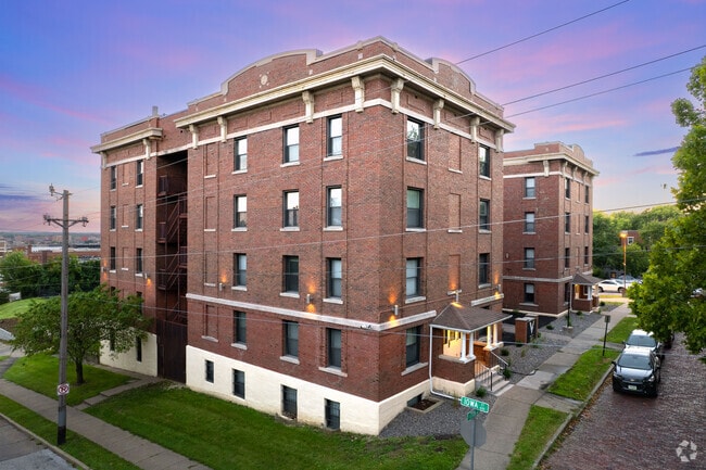

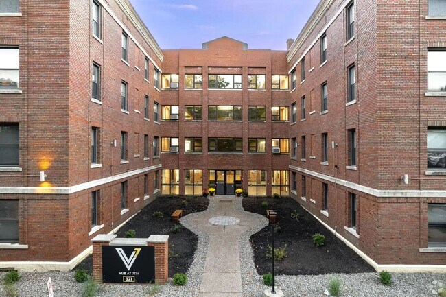

Property Detail
321 E 7Th St
Davenport-Moline-Rock Island, IA-IL
LECLAIRE'S 4TH ADD LECLAIRE'S 4TH ADDLOTS 3,4,5, 6,7,8 &THE E/2 OF LOT 9AND THE N/2 OF THE W/2 OF LOT 9 ALL IN BLOCK 69
F0049-32A
Scott
Apartment
Iowa
B and X Area of moderate flood hazard, usually the area between the limits of the 100-year and 500-year floods.
9
2025
1.49 AC
2025
Central Davenport
010600
Davenport/Moline/Rock Island
39,248 SF
NEARBY LISTINGS FOR SALE OR LEASE
DEMOGRAPHICS near 321 E 7Th St
1 mile
3 mile
5 mile
2025 Total Population
13,727
91,776
185,570
2030 Population
14,176
92,771
186,721
Pop Growth 2025-2030
+ 3.27%
+ 1.08%
+ 0.62%
Average Age
35
39
40
2025 Total Households
5,818
38,404
78,124
HH Growth 2025-2030
+ 4.40%
+ 1.23%
+ 0.70%
Median Household Inc
$41,750
$58,399
$65,451
Avg Household Size
2.00
2.20
2.30
2025 Avg HH Vehicles
1.00
2.00
2.00
Median Home Value
$124,025
$146,578
$170,816
Median Year Built
1947
1949
1959
Nearby Places
Map Layers
Map Styles
 Street
 Aerial
Layers
 Traffic
 Biking
Places
Listings with unknown addresses are not visible on the map
- Restaurants
- Banks
- Shops
- Fitness
- Groceries
PUBLIC TRANSPORTATION
AIRPORT
Quad Cities International
Drive
Walk
Distance
Quad Cities International
20 min
10.4 mi
Freight Ports
Port Milwaukee
Drive
Walk
Distance
Port Milwaukee
243 min
214.9 mi
SALE & LEASE HISTORY
LISTING DATE
SALE/LEASE

Sep 24, 2016
For Sale
Nov 22, 2017
For Sale
Nearby Properties
Address
Land Use
TOTAL SIZE
Lot Size
Zoning
Address
Land Use
TOTAL SIZE
Lot Size
Zoning
7,934 SF
8.41 AC
Address
Land Use
TOTAL SIZE
Lot Size
Zoning
3,516 SF
26.74 AC
Address
Land Use
TOTAL SIZE
Lot Size
Zoning
197,194 SF
5.14 AC
Address
Land Use
TOTAL SIZE
Lot Size
Zoning
253,608 SF
9.29 AC
Address
Land Use
TOTAL SIZE
Lot Size
Zoning
3,500 SF
1.54 AC
Address
Land Use
TOTAL SIZE
Lot Size
Zoning
190,832 SF
3.88 AC
Address
Land Use
TOTAL SIZE
Lot Size
Zoning
63,359 SF
12.01 AC
Address
Land Use
TOTAL SIZE
Lot Size
Zoning
1,980 SF
19.75 AC
Address
Land Use
TOTAL SIZE
Lot Size
Zoning
472,569 SF
47.24 AC
Address
Land Use
TOTAL SIZE
Lot Size
Zoning
61,623 SF
2.18 AC
Address
Land Use
TOTAL SIZE
Lot Size
Zoning
76,853 SF
0.56 AC
Address
Land Use
TOTAL SIZE
Lot Size
Zoning
4,944 SF
17.91 AC
Address
Land Use
TOTAL SIZE
Lot Size
Zoning
26,472 SF
17.67 AC
Address
Land Use
TOTAL SIZE
Lot Size
Zoning
77,187 SF
0.88 AC
Address
Land Use
TOTAL SIZE
Lot Size
Zoning
27,312 SF
15.04 AC
Address
Land Use
TOTAL SIZE
Lot Size
Zoning
70,098 SF
9.72 AC
Address
Land Use
TOTAL SIZE
Lot Size
Zoning
104,415 SF
5.89 AC
Address
Land Use
TOTAL SIZE
Lot Size
Zoning
9,658 SF
8.07 AC
Address
Land Use
TOTAL SIZE
Lot Size
Zoning
153,329 SF
2.35 AC
Address
Land Use
TOTAL SIZE
Lot Size
Zoning
96,529 SF
3.52 AC
Address
Land Use
TOTAL SIZE
Lot Size
Zoning
72,554 SF
0.38 AC
Address
Land Use
TOTAL SIZE
Lot Size
Zoning
50,880 SF
11.36 AC
Address
Land Use
TOTAL SIZE
Lot Size
Zoning
54,644 SF
2.41 AC
Address
Land Use
TOTAL SIZE
Lot Size
Zoning
10,724 SF
1.51 AC
Address
Land Use
TOTAL SIZE
Lot Size
Zoning
3,000 SF
59.92 AC
Address
Land Use
TOTAL SIZE
Lot Size
Zoning
32,725 SF
0.99 AC
Address
Land Use
TOTAL SIZE
Lot Size
Zoning
54,026 SF
Address
Land Use
TOTAL SIZE
Lot Size
Zoning
72,173 SF
0.66 AC
Address
Land Use
TOTAL SIZE
Lot Size
Zoning
43,343 SF
3.56 AC
Address
Land Use
TOTAL SIZE
Lot Size
Zoning
172,527 SF
1.10 AC
The World's #1 Commercial Real Estate Marketplace
Connect with us
© 2026 CoStar Group
The information above has been obtained from sources believed reliable. While we do not doubt its accuracy we have not verified it and make no guarantee, warranty or representation about it. It is your responsibility to independently confirm its accuracy and completeness. Any projections, opinions, assumptions, or estimates used are for example only and do not represent the current or future performance of the property. The value of this transaction to you depends on tax and other factors which should be evaluated by your tax, financial, and legal advisors. You and your advisors should conduct a careful, independent investigation of the property to determine to your satisfaction the suitability of the property for your needs.