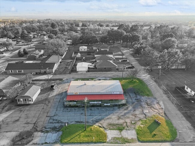
Property Record
321 E Fm 120, Pottsboro, TX 75076

Save to a Folder
{{folder.Name}}
{{folder.ListingIds.length}} Properties
{{folder.ListingIds.length}} Property
Create a New Folder
Property Detail
321 E Fm 120
Sherman-Denison, TX
POTTS TEXOMA ADDITION, BLOCK 2, LOT 4, 5, & 6
153667
GRAYSON
Commercialnec
Texas
B and X Area of moderate flood hazard, usually the area between the limits of the 100-year and 500-year floods.
4,5
2024
0.41 AC
2025
Texas North Area
000305
Other Market Areas
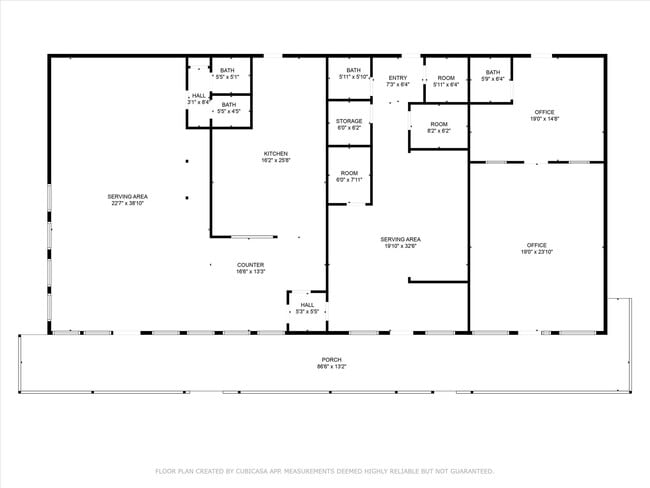
3,000 SF
NEARBY LISTINGS FOR SALE OR LEASE
DEMOGRAPHICS near 321 E Fm 120
1 mile
3 mile
5 mile
2025 Total Population
1,999
3,467
10,127
2030 Population
2,169
3,774
11,141
Pop Growth 2025-2030
+ 8.50%
+ 8.85%
+ 10.01%
Average Age
41
42
44
2025 Total Households
783
1,372
4,137
HH Growth 2025-2030
+ 8.56%
+ 8.97%
+ 10.27%
Median Household Inc
$79,790
$87,430
$88,935
Avg Household Size
2.60
2.50
2.40
2025 Avg HH Vehicles
2.00
2.00
2.00
Median Home Value
$312,952
$326,623
$333,917
Median Year Built
1992
1993
1990
Nearby Places
Map Layers
Map Styles
 Street
 Aerial
Layers
 Traffic
 Biking
Places
Listings with unknown addresses are not visible on the map
- Restaurants
- Banks
- Shops
- Fitness
- Groceries
SALE & LEASE HISTORY
LISTING DATE
SALE/LEASE

Aug 06, 2025
For Sale
Nearby Properties
Address
Land Use
TOTAL SIZE
Lot Size
Zoning
Address
Land Use
TOTAL SIZE
Lot Size
Zoning
269,202 SF
41.11 AC
Address
Land Use
TOTAL SIZE
Lot Size
Zoning
153,705 SF
70 AC
Address
Land Use
TOTAL SIZE
Lot Size
Zoning
248,932 SF
22 AC
Address
Land Use
TOTAL SIZE
Lot Size
Zoning
93,400 SF
17.22 AC
Address
Land Use
TOTAL SIZE
Lot Size
Zoning
160 AC
Address
Land Use
TOTAL SIZE
Lot Size
Zoning
37,501 SF
6.42 AC
Address
Land Use
TOTAL SIZE
Lot Size
Zoning
151.74 AC
Address
Land Use
TOTAL SIZE
Lot Size
Zoning
67,640 SF
8.80 AC
Address
Land Use
TOTAL SIZE
Lot Size
Zoning
55,450 SF
6.09 AC
Address
Land Use
TOTAL SIZE
Lot Size
Zoning
20,641 SF
Address
Land Use
TOTAL SIZE
Lot Size
Zoning
40,800 SF
2.84 AC
Address
Land Use
TOTAL SIZE
Lot Size
Zoning
14,200 SF
2.04 AC
Address
Land Use
TOTAL SIZE
Lot Size
Zoning
9,241 SF
2.27 AC
Address
Land Use
TOTAL SIZE
Lot Size
Zoning
40,756 SF
39 AC
Address
Land Use
TOTAL SIZE
Lot Size
Zoning
10,744 SF
3.87 AC
Address
Land Use
TOTAL SIZE
Lot Size
Zoning
33,390 SF
62.89 AC
Address
Land Use
TOTAL SIZE
Lot Size
Zoning
22,284 SF
80.23 AC
Address
Land Use
TOTAL SIZE
Lot Size
Zoning
7,000 SF
1.60 AC
Address
Land Use
TOTAL SIZE
Lot Size
Zoning
22,944 SF
2.94 AC
Address
Land Use
TOTAL SIZE
Lot Size
Zoning
38,944 SF
2.35 AC
Address
Land Use
TOTAL SIZE
Lot Size
Zoning
48,000 SF
4.97 AC
Address
Land Use
TOTAL SIZE
Lot Size
Zoning
16,400 SF
2.45 AC
Address
Land Use
TOTAL SIZE
Lot Size
Zoning
26,800 SF
2.81 AC
Address
Land Use
TOTAL SIZE
Lot Size
Zoning
9,718 SF
119.13 AC
Address
Land Use
TOTAL SIZE
Lot Size
Zoning
1,380 SF
5.05 AC
Address
Land Use
TOTAL SIZE
Lot Size
Zoning
20,100 SF
10.11 AC
Address
Land Use
TOTAL SIZE
Lot Size
Zoning
7,857 SF
3.75 AC
Address
Land Use
TOTAL SIZE
Lot Size
Zoning
7,246 SF
0.77 AC
Address
Land Use
TOTAL SIZE
Lot Size
Zoning
12,660 SF
2.25 AC
Address
Land Use
TOTAL SIZE
Lot Size
Zoning
8,000 SF
0.82 AC
The World's #1 Commercial Real Estate Marketplace
Connect with us
© 2026 CoStar Group
The information above has been obtained from sources believed reliable. While we do not doubt its accuracy we have not verified it and make no guarantee, warranty or representation about it. It is your responsibility to independently confirm its accuracy and completeness. Any projections, opinions, assumptions, or estimates used are for example only and do not represent the current or future performance of the property. The value of this transaction to you depends on tax and other factors which should be evaluated by your tax, financial, and legal advisors. You and your advisors should conduct a careful, independent investigation of the property to determine to your satisfaction the suitability of the property for your needs.