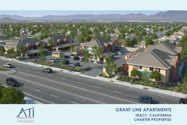
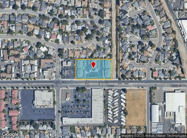
Property Record
321 E Grant Line Rd, Tracy, CA 95376
Property Detail
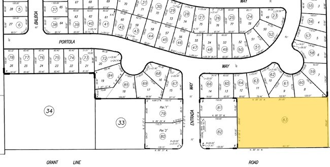
321 E Grant Line Rd
214-320-83
Rancho El Pescadero
Multifamilydwelling
TWP 02S RGE 05E SEC 16 QTR SE4
X
San Joaquin
06077C0595F
California
2025
1.67 AC
2025
Tracy/Manteca
005310
Stockton/Modesto
7,707 SF
Stockton-Lodi, CA
NEARBY LISTINGS FOR SALE OR LEASE
DEMOGRAPHICS near 321 E Grant Line Rd
1 mile
3 mile
5 mile
2024 Total Population
15,652
73,326
103,595
2029 Population
16,480
77,284
109,333
Pop Growth 2024-2029
+ 5.29%
+ 5.40%
+ 5.54%
Average Age
36
37
37
2024 Total Households
4,947
22,179
30,426
HH Growth 2024-2029
+ 5.36%
+ 5.41%
+ 5.63%
Median Household Inc
$80,667
$101,205
$110,448
Avg Household Size
3.10
3.20
3.30
2024 Avg HH Vehicles
2.00
2.00
3.00
Median Home Value
$441,142
$580,749
$641,019
Median Year Built
1969
1989
1994
Nearby Places
Map Layers
Map Styles
 Street
 Aerial
Transit
 Traffic
 Biking
Places
Listings with unknown addresses are not visible on the map
- Restaurants
- Banks
- Shops
- Fitness
- Groceries
PUBLIC TRANSPORTATION
COMMUTER RAIL
Drive
Walk
Distance
9 min
5.0 mi
AIRPORT
Stockton Metro
Drive
Walk
Distance
Stockton Metro
24 min
18.3 mi
SALE & LEASE HISTORY
LISTING DATE
SALE/LEASE

Jun 22, 2018
For Sale
Nearby Properties
Address
Land Use
TOTAL SIZE
Lot Size
Zoning
Address
Land Use
TOTAL SIZE
Lot Size
Zoning
3,485,402 SF
86.48 AC
Address
Land Use
TOTAL SIZE
Lot Size
Zoning
610,914 SF
28.11 AC
M1
Address
Land Use
TOTAL SIZE
Lot Size
Zoning
8.90 AC
Address
Land Use
TOTAL SIZE
Lot Size
Zoning
925,475 SF
42.09 AC
Address
Land Use
TOTAL SIZE
Lot Size
Zoning
1,601 SF
17.08 AC
PUD1
Address
Land Use
TOTAL SIZE
Lot Size
Zoning
657,600 SF
44.03 AC
Address
Land Use
TOTAL SIZE
Lot Size
Zoning
3.77 AC
Address
Land Use
TOTAL SIZE
Lot Size
Zoning
1,124,201 SF
53.72 AC
Address
Land Use
TOTAL SIZE
Lot Size
Zoning
795,732 SF
36.67 AC
IG
Address
Land Use
TOTAL SIZE
Lot Size
Zoning
22,926 SF
11.63 AC
Address
Land Use
TOTAL SIZE
Lot Size
Zoning
749,840 SF
37.96 AC
Address
Land Use
TOTAL SIZE
Lot Size
Zoning
24.07 AC
Address
Land Use
TOTAL SIZE
Lot Size
Zoning
567,870 SF
36.41 AC
M1
Address
Land Use
TOTAL SIZE
Lot Size
Zoning
461,810 SF
23.23 AC
PUD3
Address
Land Use
TOTAL SIZE
Lot Size
Zoning
827,280 SF
36.18 AC
Address
Land Use
TOTAL SIZE
Lot Size
Zoning
9,327 SF
12.06 AC
Address
Land Use
TOTAL SIZE
Lot Size
Zoning
381,600 SF
19.46 AC
Address
Land Use
TOTAL SIZE
Lot Size
Zoning
309,108 SF
19.39 AC
Address
Land Use
TOTAL SIZE
Lot Size
Zoning
442,350 SF
27.01 AC
CN
Address
Land Use
TOTAL SIZE
Lot Size
Zoning
575,167 SF
46.44 AC
Address
Land Use
TOTAL SIZE
Lot Size
Zoning
532,500 SF
25.15 AC
Address
Land Use
TOTAL SIZE
Lot Size
Zoning
265,868 SF
11.99 AC
Address
Land Use
TOTAL SIZE
Lot Size
Zoning
265,000 SF
10.83 AC
Address
Land Use
TOTAL SIZE
Lot Size
Zoning
49,264 SF
9 AC
Address
Land Use
TOTAL SIZE
Lot Size
Zoning
126,204 SF
110.07 AC
Address
Land Use
TOTAL SIZE
Lot Size
Zoning
258,520 SF
16.74 AC
The World's #1 Commercial Real Estate Marketplace
Connect with us
© 2026 CoStar Group
The information above has been obtained from sources believed reliable. While we do not doubt its accuracy we have not verified it and make no guarantee, warranty or representation about it. It is your responsibility to independently confirm its accuracy and completeness. Any projections, opinions, assumptions, or estimates used are for example only and do not represent the current or future performance of the property. The value of this transaction to you depends on tax and other factors which should be evaluated by your tax, financial, and legal advisors. You and your advisors should conduct a careful, independent investigation of the property to determine to your satisfaction the suitability of the property for your needs.