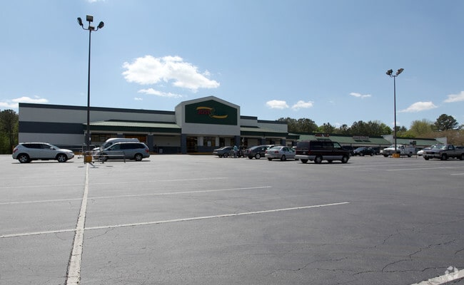
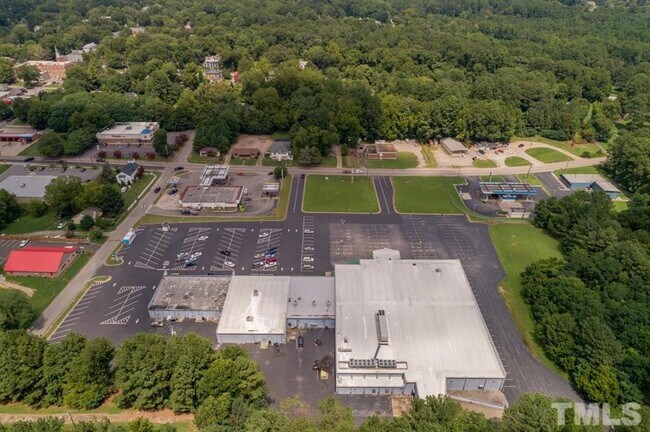
Property Record
321 E Macon St, Warrenton, NC 27589

Property Detail
321 E Macon St
E6B475
E MACON ST SHOPPING CNTR
Commercialnec
Warren
B and X Area of moderate flood hazard, usually the area between the limits of the 100-year and 500-year floods.
North Carolina
2025
7.42 AC
2025
North Carolina Northeast Area
950300
Other Market Areas
18,732 SF
NEARBY LISTINGS FOR SALE OR LEASE
DEMOGRAPHICS near 321 E Macon St
1 mile
3 mile
5 mile
2025 Total Population
1,355
3,034
5,815
2030 Population
1,376
3,081
5,875
Pop Growth 2025-2030
+ 1.55%
+ 1.55%
+ 1.03%
Average Age
44
44
44
2025 Total Households
563
1,256
2,431
HH Growth 2025-2030
+ 1.42%
+ 1.43%
+ 0.82%
Median Household Inc
$41,346
$42,270
$41,666
Avg Household Size
2.20
2.20
2.20
2025 Avg HH Vehicles
2.00
2.00
2.00
Median Home Value
$159,473
$154,807
$129,441
Median Year Built
1976
1976
1979
Nearby Places
Map Layers
Map Styles
 Street
 Aerial
Layers
 Traffic
 Biking
Places
Listings with unknown addresses are not visible on the map
- Restaurants
- Banks
- Shops
- Fitness
- Groceries
SALE & LEASE HISTORY
LISTING DATE
SALE/LEASE

Sep 25, 2016
For Lease
Sep 12, 2023
For Sale
Jun 07, 2019
For Lease
Jun 07, 2019
For Sale
Apr 11, 2017
For Lease
Apr 08, 2024
For Sale
Nearby Properties
Address
Land Use
TOTAL SIZE
Lot Size
Zoning
Address
Land Use
TOTAL SIZE
Lot Size
Zoning
83,898 SF
35.56 AC
Address
Land Use
TOTAL SIZE
Lot Size
Zoning
31,183 SF
10.57 AC
Address
Land Use
TOTAL SIZE
Lot Size
Zoning
3,690 SF
905 AC
Address
Land Use
TOTAL SIZE
Lot Size
Zoning
22,128 SF
12.35 AC
Address
Land Use
TOTAL SIZE
Lot Size
Zoning
2,788 SF
33.40 AC
Address
Land Use
TOTAL SIZE
Lot Size
Zoning
22,504 SF
13.14 AC
Address
Land Use
TOTAL SIZE
Lot Size
Zoning
22,398 SF
10.20 AC
Address
Land Use
TOTAL SIZE
Lot Size
Zoning
29,903 SF
10.71 AC
Address
Land Use
TOTAL SIZE
Lot Size
Zoning
2,256 SF
428 AC
Address
Land Use
TOTAL SIZE
Lot Size
Zoning
2,234 SF
620 AC
Address
Land Use
TOTAL SIZE
Lot Size
Zoning
6,603 SF
6 AC
RV0413
Address
Land Use
TOTAL SIZE
Lot Size
Zoning
11,999 SF
4.78 AC
Address
Land Use
TOTAL SIZE
Lot Size
Zoning
104.78 AC
Address
Land Use
TOTAL SIZE
Lot Size
Zoning
5,000 SF
1.07 AC
Address
Land Use
TOTAL SIZE
Lot Size
Zoning
12,896 SF
1 AC
Address
Land Use
TOTAL SIZE
Lot Size
Zoning
10,488 SF
2.67 AC
Address
Land Use
TOTAL SIZE
Lot Size
Zoning
12,885 SF
450 AC
Address
Land Use
TOTAL SIZE
Lot Size
Zoning
10,209 SF
218 AC
Address
Land Use
TOTAL SIZE
Lot Size
Zoning
9,372 SF
1 AC
Address
Land Use
TOTAL SIZE
Lot Size
Zoning
10,249 SF
1 AC
Address
Land Use
TOTAL SIZE
Lot Size
Zoning
11,586 SF
225 AC
Address
Land Use
TOTAL SIZE
Lot Size
Zoning
36,132 SF
1.74 AC
Address
Land Use
TOTAL SIZE
Lot Size
Zoning
6,476 SF
13.26 AC
Address
Land Use
TOTAL SIZE
Lot Size
Zoning
8,467 SF
1 AC
RV0911
Address
Land Use
TOTAL SIZE
Lot Size
Zoning
9,600 SF
8.04 AC
RV0910
Address
Land Use
TOTAL SIZE
Lot Size
Zoning
2,383 SF
1.50 AC
Address
Land Use
TOTAL SIZE
Lot Size
Zoning
672.95 AC
Address
Land Use
TOTAL SIZE
Lot Size
Zoning
1,657 SF
3.21 AC
Address
Land Use
TOTAL SIZE
Lot Size
Zoning
280.20 AC
The World's #1 Commercial Real Estate Marketplace
Connect with us
© 2026 CoStar Group
The information above has been obtained from sources believed reliable. While we do not doubt its accuracy we have not verified it and make no guarantee, warranty or representation about it. It is your responsibility to independently confirm its accuracy and completeness. Any projections, opinions, assumptions, or estimates used are for example only and do not represent the current or future performance of the property. The value of this transaction to you depends on tax and other factors which should be evaluated by your tax, financial, and legal advisors. You and your advisors should conduct a careful, independent investigation of the property to determine to your satisfaction the suitability of the property for your needs.