Property Record
325 E Maple St, Cumming, GA 30040
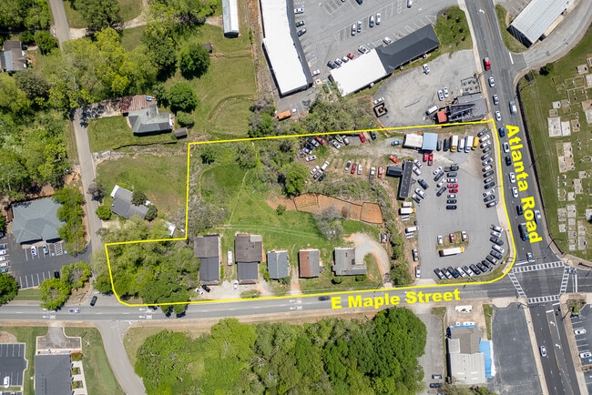
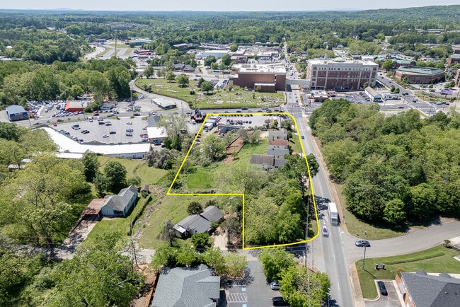
This Property Is For Sale
Property Detail
325 E Maple St
C16-100
3 1 1269 .02 TO DOT----1993
Commercialnec
Forsyth
CBD
Georgia
B and X Area of moderate flood hazard, usually the area between the limits of the 100-year and 500-year floods.
1269
2025
0.25 AC
2025
N Fulton/Forsyth County
130410
Atlanta
1,194 SF
Atlanta-Sandy Springs-Roswell, GA
NEARBY LISTINGS FOR SALE OR LEASE
DEMOGRAPHICS near 325 E Maple St
1 mile
3 mile
5 mile
2025 Total Population
4,378
41,137
106,242
2030 Population
4,824
44,878
115,823
Pop Growth 2025-2030
+ 10.19%
+ 9.09%
+ 9.02%
Average Age
41
40
40
2025 Total Households
1,608
14,721
36,354
HH Growth 2025-2030
+ 10.20%
+ 9.07%
+ 9.01%
Median Household Inc
$74,194
$109,224
$125,630
Avg Household Size
2.50
2.70
2.90
2025 Avg HH Vehicles
2.00
2.00
2.00
Median Home Value
$459,426
$509,000
$602,188
Median Year Built
1997
2002
2003
Nearby Places
Map Layers
Map Styles
 Street
 Aerial
Layers
 Traffic
 Biking
Places
Listings with unknown addresses are not visible on the map
- Restaurants
- Banks
- Shops
- Fitness
- Groceries
Nearby Properties
Address
Land Use
TOTAL SIZE
Lot Size
Zoning
Address
Land Use
TOTAL SIZE
Lot Size
Zoning
868,971 SF
31.45 AC
INST
Address
Land Use
TOTAL SIZE
Lot Size
Zoning
405,715 SF
15.75 AC
PUD
Address
Land Use
TOTAL SIZE
Lot Size
Zoning
344,278 SF
10.82 AC
PUD
Address
Land Use
TOTAL SIZE
Lot Size
Zoning
340,073 SF
10.57 AC
PUD
Address
Land Use
TOTAL SIZE
Lot Size
Zoning
282,935 SF
27.53 AC
R3
Address
Land Use
TOTAL SIZE
Lot Size
Zoning
208,496 SF
23.61 AC
R3
Address
Land Use
TOTAL SIZE
Lot Size
Zoning
276,750 SF
28.86 AC
PSC
Address
Land Use
TOTAL SIZE
Lot Size
Zoning
302,599 SF
35.89 AC
R3
Address
Land Use
TOTAL SIZE
Lot Size
Zoning
221,163 SF
21.98 AC
R3
Address
Land Use
TOTAL SIZE
Lot Size
Zoning
291,064 SF
32.90 AC
CBD
Address
Land Use
TOTAL SIZE
Lot Size
Zoning
137,204 SF
6.49 AC
PUD
Address
Land Use
TOTAL SIZE
Lot Size
Zoning
171,065 SF
16.22 AC
CBD
Address
Land Use
TOTAL SIZE
Lot Size
Zoning
132,724 SF
43.76 AC
INST
Address
Land Use
TOTAL SIZE
Lot Size
Zoning
399,158 SF
24.78 AC
INST
Address
Land Use
TOTAL SIZE
Lot Size
Zoning
282,874 SF
28.70 AC
INST
Address
Land Use
TOTAL SIZE
Lot Size
Zoning
120,750 SF
9.37 AC
INST
Address
Land Use
TOTAL SIZE
Lot Size
Zoning
131,546 SF
15.29 AC
PSC
Address
Land Use
TOTAL SIZE
Lot Size
Zoning
152,562 SF
12.80 AC
R3
Address
Land Use
TOTAL SIZE
Lot Size
Zoning
190,604 SF
29.19 AC
MU
Address
Land Use
TOTAL SIZE
Lot Size
Zoning
127,940 SF
14.30 AC
HB
Address
Land Use
TOTAL SIZE
Lot Size
Zoning
99,232 SF
Address
Land Use
TOTAL SIZE
Lot Size
Zoning
92,992 SF
12.94 AC
CBD
Address
Land Use
TOTAL SIZE
Lot Size
Zoning
372,396 SF
31.01 AC
INST
Address
Land Use
TOTAL SIZE
Lot Size
Zoning
111,194 SF
13.53 AC
NS
Address
Land Use
TOTAL SIZE
Lot Size
Zoning
85,398 SF
Address
Land Use
TOTAL SIZE
Lot Size
Zoning
277,749 SF
55.50 AC
INST
Address
Land Use
TOTAL SIZE
Lot Size
Zoning
60,392 SF
1.66 AC
CBD
Address
Land Use
TOTAL SIZE
Lot Size
Zoning
89,312 SF
7.50 AC
M1
Address
Land Use
TOTAL SIZE
Lot Size
Zoning
199,482 SF
34.26 AC
HB
Address
Land Use
TOTAL SIZE
Lot Size
Zoning
175,801 SF
2.13 AC
CBD
The World's #1 Commercial Real Estate Marketplace
Connect with us
© 2026 CoStar Group
The information above has been obtained from sources believed reliable. While we do not doubt its accuracy we have not verified it and make no guarantee, warranty or representation about it. It is your responsibility to independently confirm its accuracy and completeness. Any projections, opinions, assumptions, or estimates used are for example only and do not represent the current or future performance of the property. The value of this transaction to you depends on tax and other factors which should be evaluated by your tax, financial, and legal advisors. You and your advisors should conduct a careful, independent investigation of the property to determine to your satisfaction the suitability of the property for your needs.