Property Record
321 E North St, Warrensburg, MO 64093
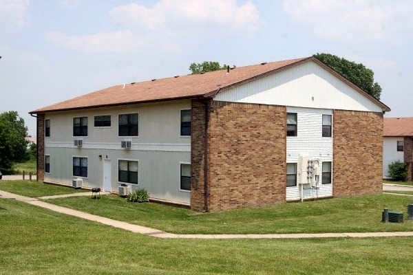
Property Detail
321 E North St
Warrensburg, MO
ELECTRIC SPRINGS PARK LT 200 .201
12602401002001600
Johnson
Apartment
Missouri
B and X Area of moderate flood hazard, usually the area between the limits of the 100-year and 500-year floods.
200
2025
2.50 AC
2025
Johnson County MO
960600
Kansas City
6,580 SF
NEARBY LISTINGS FOR SALE OR LEASE
-
-
View all Warrensburg listings for sale on LoopNet.com
DEMOGRAPHICS near 321 E North St
1 mile
3 mile
5 mile
2025 Total Population
11,144
24,195
27,433
2030 Population
11,701
25,330
28,675
Pop Growth 2025-2030
+ 5.00%
+ 4.69%
+ 4.53%
Average Age
32
34
34
2025 Total Households
4,074
9,069
10,317
HH Growth 2025-2030
+ 5.82%
+ 5.25%
+ 5.04%
Median Household Inc
$50,909
$59,259
$60,528
Avg Household Size
2.10
2.30
2.30
2025 Avg HH Vehicles
2.00
2.00
2.00
Median Home Value
$213,948
$242,743
$244,245
Median Year Built
1982
1990
1990
Nearby Places
Map Layers
Map Styles
 Street
 Aerial
Layers
 Traffic
 Biking
Places
Listings with unknown addresses are not visible on the map
- Restaurants
- Banks
- Shops
- Fitness
- Groceries
PUBLIC TRANSPORTATION
COMMUTER RAIL
Warrensburg Amtrak Station (Lincoln Service Missouri River Runner - Amtrak, Missouri River Runner - Amtrak)
Drive
Walk
Distance
Warrensburg Amtrak Station (Lincoln Service Missouri River Runner - Amtrak, Missouri River Runner - Amtrak)
2 min
13 min
0.7 mi
Freight Ports
Tulsa Port Of Catoosa
Drive
Walk
Distance
Tulsa Port Of Catoosa
298 min
261.3 mi
Nearby Properties
Address
Land Use
TOTAL SIZE
Lot Size
Zoning
Address
Land Use
TOTAL SIZE
Lot Size
Zoning
150,228 SF
26.79 AC
Address
Land Use
TOTAL SIZE
Lot Size
Zoning
205,785 SF
24.20 AC
Address
Land Use
TOTAL SIZE
Lot Size
Zoning
112,082 SF
10.79 AC
Address
Land Use
TOTAL SIZE
Lot Size
Zoning
47,434 SF
3.24 AC
Address
Land Use
TOTAL SIZE
Lot Size
Zoning
4,552 SF
8.01 AC
Address
Land Use
TOTAL SIZE
Lot Size
Zoning
43,053 SF
2.79 AC
Address
Land Use
TOTAL SIZE
Lot Size
Zoning
68,000 SF
12 AC
Address
Land Use
TOTAL SIZE
Lot Size
Zoning
54,960 SF
15 AC
Address
Land Use
TOTAL SIZE
Lot Size
Zoning
27,306 SF
2.69 AC
Address
Land Use
TOTAL SIZE
Lot Size
Zoning
27,022 SF
1.75 AC
Address
Land Use
TOTAL SIZE
Lot Size
Zoning
3,900 SF
6.77 AC
Address
Land Use
TOTAL SIZE
Lot Size
Zoning
11,493 SF
2.54 AC
Address
Land Use
TOTAL SIZE
Lot Size
Zoning
44,818 SF
2.24 AC
Address
Land Use
TOTAL SIZE
Lot Size
Zoning
32,828 SF
2.40 AC
Address
Land Use
TOTAL SIZE
Lot Size
Zoning
3,914 SF
5.92 AC
Address
Land Use
TOTAL SIZE
Lot Size
Zoning
12,212 SF
1.45 AC
Address
Land Use
TOTAL SIZE
Lot Size
Zoning
75,899 SF
5.25 AC
Address
Land Use
TOTAL SIZE
Lot Size
Zoning
9,904 SF
0.21 AC
Address
Land Use
TOTAL SIZE
Lot Size
Zoning
21,892 SF
3.04 AC
Address
Land Use
TOTAL SIZE
Lot Size
Zoning
21,290 SF
4.70 AC
Address
Land Use
TOTAL SIZE
Lot Size
Zoning
3,622 SF
4.83 AC
Address
Land Use
TOTAL SIZE
Lot Size
Zoning
3,600 SF
7.29 AC
Address
Land Use
TOTAL SIZE
Lot Size
Zoning
141,627 SF
12 AC
Address
Land Use
TOTAL SIZE
Lot Size
Zoning
34,272 SF
3.06 AC
Address
Land Use
TOTAL SIZE
Lot Size
Zoning
4,500 SF
5.18 AC
Address
Land Use
TOTAL SIZE
Lot Size
Zoning
52,925 SF
5.53 AC
Address
Land Use
TOTAL SIZE
Lot Size
Zoning
19,553 SF
2.74 AC
Address
Land Use
TOTAL SIZE
Lot Size
Zoning
16,102 SF
4.06 AC
Address
Land Use
TOTAL SIZE
Lot Size
Zoning
13,002 SF
0.27 AC
Address
Land Use
TOTAL SIZE
Lot Size
Zoning
23,937 SF
7.34 AC
The World's #1 Commercial Real Estate Marketplace
Connect with us
© 2026 CoStar Group
The information above has been obtained from sources believed reliable. While we do not doubt its accuracy we have not verified it and make no guarantee, warranty or representation about it. It is your responsibility to independently confirm its accuracy and completeness. Any projections, opinions, assumptions, or estimates used are for example only and do not represent the current or future performance of the property. The value of this transaction to you depends on tax and other factors which should be evaluated by your tax, financial, and legal advisors. You and your advisors should conduct a careful, independent investigation of the property to determine to your satisfaction the suitability of the property for your needs.