Property Record
321 Hamric Dr W, Oxford, AL 36203


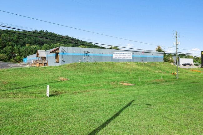
This Property Is For Sale
NEARBY LISTINGS FOR SALE OR LEASE
-
-
View all Oxford listings for sale on LoopNet.com
Property Detail
321 Hamric Dr W
21-09-30-3-001-021.000
SEC 30 T16S R08E A PARCEL IN NW 1/4 SW 1/4 DESC AS BEG ON N SIDE W 9TH STREET 243.9 SE OF NW COR SW 1/4 NE ALG ST 300.5 SE 74
Warehouse
Calhoun
X
Alabama
01015C0401E
5.19 AC
2025
Gadsden/Anniston Area
2025
Other Market Areas
001201
Anniston-Oxford-Jacksonville, AL
53,380 SF
DEMOGRAPHICS near 321 Hamric Dr W
1 Mile
3 Mile
5 Mile
2024 Total Population
2,847
17,672
43,243
2029 Population
2,828
17,624
43,400
Pop Growth 2024-2029
(0.67%)
(0.27%)
+ 0.36%
Average Age
40
40
42
2024 Total Households
1,090
7,005
17,636
HH Growth 2024-2029
(0.83%)
(0.39%)
+ 0.33%
Median Household Inc
$40,141
$52,658
$53,285
Avg Household Size
2.40
2.40
2.30
2024 Avg HH Vehicles
2.00
2.00
2.00
Median Home Value
$154,181
$168,862
$158,554
Median Year Built
1970
1978
1975
Nearby Places
Map Layers
Map Styles
 Street
 Aerial
- Restaurants
- Banks
- Shops
- Fitness
- Groceries
PUBLIC TRANSPORTATION
COMMUTER RAIL
Anniston Amtrak Station (Crescent - Amtrak)
DRIVE
WALK
Distance
Anniston Amtrak Station (Crescent - Amtrak)
7 min
4.0 mi
Freight Ports
Port of Panama City
DRIVE
WALK
Distance
Port of Panama City
358 min
289.7 mi
Nearby Properties
Address
Land Use
TOTAL SIZE
Lot Size
Zoning
Address
Land Use
TOTAL SIZE
Lot Size
Zoning
128,399 SF
17 AC
Address
Land Use
TOTAL SIZE
Lot Size
Zoning
5.32 AC
Address
Land Use
TOTAL SIZE
Lot Size
Zoning
7,752 SF
182 AC
Address
Land Use
TOTAL SIZE
Lot Size
Zoning
18.90 AC
Address
Land Use
TOTAL SIZE
Lot Size
Zoning
1,972 SF
22.80 AC
Address
Land Use
TOTAL SIZE
Lot Size
Zoning
17,254 SF
22 AC
Address
Land Use
TOTAL SIZE
Lot Size
Zoning
87,750 SF
25 AC
Address
Land Use
TOTAL SIZE
Lot Size
Zoning
341,374 SF
15.88 AC
Address
Land Use
TOTAL SIZE
Lot Size
Zoning
201,670 SF
27.50 AC
Address
Land Use
TOTAL SIZE
Lot Size
Zoning
346,532 SF
41 AC
Address
Land Use
TOTAL SIZE
Lot Size
Zoning
14,015 SF
8.50 AC
Address
Land Use
TOTAL SIZE
Lot Size
Zoning
12,695 SF
0.75 AC
Address
Land Use
TOTAL SIZE
Lot Size
Zoning
86,508 SF
20 AC
Address
Land Use
TOTAL SIZE
Lot Size
Zoning
Address
Land Use
TOTAL SIZE
Lot Size
Zoning
31,104 SF
36 AC
Address
Land Use
TOTAL SIZE
Lot Size
Zoning
4,118 SF
15.74 AC
Address
Land Use
TOTAL SIZE
Lot Size
Zoning
6,400 SF
12.24 AC
Address
Land Use
TOTAL SIZE
Lot Size
Zoning
98,306 SF
20 AC
Address
Land Use
TOTAL SIZE
Lot Size
Zoning
128,064 SF
7.70 AC
Address
Land Use
TOTAL SIZE
Lot Size
Zoning
194,310 SF
9.11 AC
Address
Land Use
TOTAL SIZE
Lot Size
Zoning
82,787 SF
8.55 AC
Address
Land Use
TOTAL SIZE
Lot Size
Zoning
10,479 SF
9.56 AC
Address
Land Use
TOTAL SIZE
Lot Size
Zoning
3.50 AC
Address
Land Use
TOTAL SIZE
Lot Size
Zoning
23,307 SF
4.51 AC
Address
Land Use
TOTAL SIZE
Lot Size
Zoning
85,305 SF
1.11 AC
Address
Land Use
TOTAL SIZE
Lot Size
Zoning
15,080 SF
24 AC
Address
Land Use
TOTAL SIZE
Lot Size
Zoning
24,132 SF
5.02 AC
Address
Land Use
TOTAL SIZE
Lot Size
Zoning
80,640 SF
9.30 AC
Address
Land Use
TOTAL SIZE
Lot Size
Zoning
14,772 SF
5.05 AC
Address
Land Use
TOTAL SIZE
Lot Size
Zoning
31,522 SF
4.23 AC
The World's #1 Commercial Real Estate Marketplace
Connect with us
© 2026 CoStar Group
The information above has been obtained from sources believed reliable. While we do not doubt its accuracy we have not verified it and make no guarantee, warranty or representation about it. It is your responsibility to independently confirm its accuracy and completeness. Any projections, opinions, assumptions, or estimates used are for example only and do not represent the current or future performance of the property. The value of this transaction to you depends on tax and other factors which should be evaluated by your tax, financial, and legal advisors. You and your advisors should conduct a careful, independent investigation of the property to determine to your satisfaction the suitability of the property for your needs.