Property Record
321 Mary Esther Blvd, Mary Esther, FL 32569


NEARBY LISTINGS FOR SALE OR LEASE
Property Detail
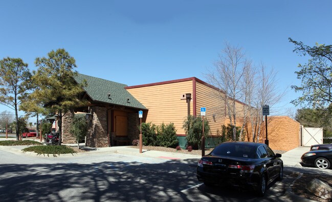
321 Mary Esther Blvd
16-2S-24-0000-0002-0010
BEG 137.5 FT S & 32.69 FT W OF NE COR OF SW1/4 OF NE1/4 W487 FT SW ALG R/W 147 FT E487 FT N14 DEG E147 FT TO BEG AS OR
Restaurantbuilding
Okaloosa
X
Florida
12091C0442J
10
2025
1.61 AC
2025
Fort Walton Beach
022900
Other Market Areas
8,028 SF
Crestview-Fort Walton Beach-Destin, FL
DEMOGRAPHICS near 321 Mary Esther Blvd
1 Mile
3 Mile
5 Mile
2024 Total Population
7,517
42,252
68,987
2029 Population
7,853
44,325
72,535
Pop Growth 2024-2029
+ 4.47%
+ 4.91%
+ 5.14%
Average Age
39
40
40
2024 Total Households
3,077
18,070
29,503
HH Growth 2024-2029
+ 4.32%
+ 5.04%
+ 5.33%
Median Household Inc
$56,502
$57,149
$59,207
Avg Household Size
2.40
2.20
2.20
2024 Avg HH Vehicles
2.00
2.00
2.00
Median Home Value
$221,971
$254,003
$273,645
Median Year Built
1978
1980
1981
Nearby Places
Map Layers
Map Styles
 Street
 Aerial
- Restaurants
- Banks
- Shops
- Fitness
- Groceries
PUBLIC TRANSPORTATION
AIRPORT
Eglin AFB/Destin-Ft Walton Beach
DRIVE
WALK
Distance
Eglin AFB/Destin-Ft Walton Beach
30 min
13.2 mi
Freight Ports
Port of Panama City
DRIVE
WALK
Distance
Port of Panama City
99 min
61.1 mi
SALE & LEASE HISTORY
LISTING DATE
SALE/LEASE

Sep 05, 2018
For Lease
Dec 05, 2016
For Lease
Dec 05, 2016
For Sale
Nearby Properties
Address
Land Use
TOTAL SIZE
Lot Size
Zoning
Address
Land Use
TOTAL SIZE
Lot Size
Zoning
1,954.92 AC
Address
Land Use
TOTAL SIZE
Lot Size
Zoning
173,879 SF
9 AC
Address
Land Use
TOTAL SIZE
Lot Size
Zoning
342,628 SF
14.83 AC
Address
Land Use
TOTAL SIZE
Lot Size
Zoning
117,852 SF
13.39 AC
Address
Land Use
TOTAL SIZE
Lot Size
Zoning
295,771 SF
18.52 AC
Address
Land Use
TOTAL SIZE
Lot Size
Zoning
120,159 SF
14.82 AC
Address
Land Use
TOTAL SIZE
Lot Size
Zoning
8,066.36 AC
Address
Land Use
TOTAL SIZE
Lot Size
Zoning
60,223 SF
2.73 AC
Address
Land Use
TOTAL SIZE
Lot Size
Zoning
216,839 SF
9.63 AC
Address
Land Use
TOTAL SIZE
Lot Size
Zoning
55,566 SF
5.40 AC
Address
Land Use
TOTAL SIZE
Lot Size
Zoning
Address
Land Use
TOTAL SIZE
Lot Size
Zoning
182,844 SF
20.62 AC
Address
Land Use
TOTAL SIZE
Lot Size
Zoning
140,945 SF
80.64 AC
Address
Land Use
TOTAL SIZE
Lot Size
Zoning
62,097 SF
4.86 AC
Address
Land Use
TOTAL SIZE
Lot Size
Zoning
75,892 SF
1.72 AC
Address
Land Use
TOTAL SIZE
Lot Size
Zoning
50,294 SF
0.94 AC
Address
Land Use
TOTAL SIZE
Lot Size
Zoning
3,894 SF
315.07 AC
Address
Land Use
TOTAL SIZE
Lot Size
Zoning
121,164 SF
5.78 AC
Address
Land Use
TOTAL SIZE
Lot Size
Zoning
51,030 SF
1.82 AC
Address
Land Use
TOTAL SIZE
Lot Size
Zoning
108,284 SF
5.47 AC
Address
Land Use
TOTAL SIZE
Lot Size
Zoning
287,257 SF
13.86 AC
Address
Land Use
TOTAL SIZE
Lot Size
Zoning
229,805 SF
19.31 AC
Address
Land Use
TOTAL SIZE
Lot Size
Zoning
79,960 SF
0.96 AC
Address
Land Use
TOTAL SIZE
Lot Size
Zoning
Address
Land Use
TOTAL SIZE
Lot Size
Zoning
71,050 SF
2.52 AC
Address
Land Use
TOTAL SIZE
Lot Size
Zoning
78,958 SF
7.88 AC
Address
Land Use
TOTAL SIZE
Lot Size
Zoning
34,385 SF
0.30 AC
Address
Land Use
TOTAL SIZE
Lot Size
Zoning
146,143 SF
19.39 AC
Address
Land Use
TOTAL SIZE
Lot Size
Zoning
51,195 SF
6.10 AC
Address
Land Use
TOTAL SIZE
Lot Size
Zoning
16,204 SF
254.05 AC
The World's #1 Commercial Real Estate Marketplace
Connect with us
© 2026 CoStar Group
The information above has been obtained from sources believed reliable. While we do not doubt its accuracy we have not verified it and make no guarantee, warranty or representation about it. It is your responsibility to independently confirm its accuracy and completeness. Any projections, opinions, assumptions, or estimates used are for example only and do not represent the current or future performance of the property. The value of this transaction to you depends on tax and other factors which should be evaluated by your tax, financial, and legal advisors. You and your advisors should conduct a careful, independent investigation of the property to determine to your satisfaction the suitability of the property for your needs.