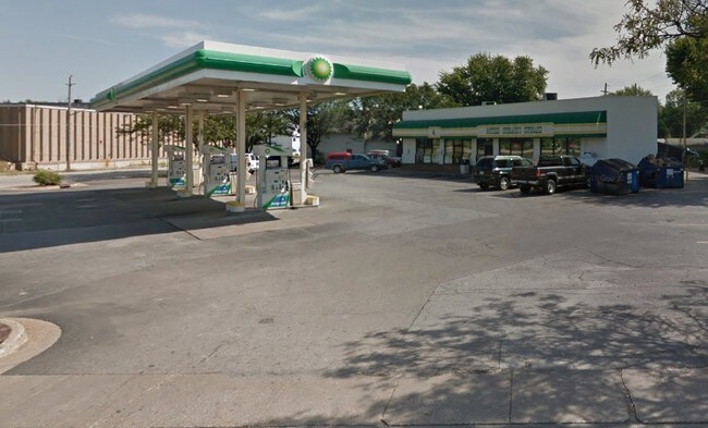
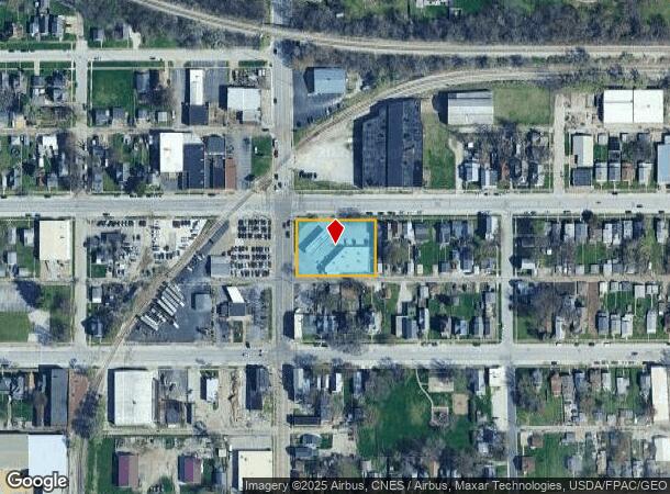
Property Record
321 N Division St, Davenport, IA 52802
NEARBY LISTINGS FOR SALE OR LEASE
Property Detail
321 N Division St
Davenport-Moline-Rock Island, IA-IL
Green's 2Nd Add
K0005-18A
GREEN'S 2ND ADD LOT: 010 BLOCK: 003 GREEN'S 2ND ADD LOTS10,11,12, & W 30'LOT13
Conveniencestore
Scott
X
Iowa
19163C0365H
10,13
2025
0.72 AC
2025
Greater Davenport
010900
Davenport/Moline/Rock Island
6,094 SF
DEMOGRAPHICS near 321 N Division St
1 Mile
3 Mile
5 Mile
2024 Total Population
9,963
76,590
152,667
2029 Population
9,854
76,187
151,231
Pop Growth 2024-2029
(1.09%)
(0.53%)
(0.94%)
Average Age
39
39
39
2024 Total Households
4,014
31,726
63,955
HH Growth 2024-2029
(1.05%)
(0.49%)
(0.97%)
Median Household Inc
$39,515
$50,041
$54,504
Avg Household Size
2.30
2.20
2.20
2024 Avg HH Vehicles
2.00
2.00
2.00
Median Home Value
$75,172
$120,220
$141,964
Median Year Built
1946
1949
1957
Nearby Places
Map Layers
Map Styles
 Street
 Aerial
- Restaurants
- Banks
- Shops
- Fitness
- Groceries
PUBLIC TRANSPORTATION
AIRPORT
Quad Cities International
DRIVE
WALK
Distance
Quad Cities International
20 min
10.5 mi
Freight Ports
Port Milwaukee
DRIVE
WALK
Distance
Port Milwaukee
245 min
211.0 mi
Nearby Properties
Address
Land Use
TOTAL SIZE
Lot Size
Zoning
Address
Land Use
TOTAL SIZE
Lot Size
Zoning
7,934 SF
8.41 AC
Address
Land Use
TOTAL SIZE
Lot Size
Zoning
3,516 SF
26.74 AC
Address
Land Use
TOTAL SIZE
Lot Size
Zoning
197,194 SF
5.14 AC
Address
Land Use
TOTAL SIZE
Lot Size
Zoning
253,608 SF
9.29 AC
Address
Land Use
TOTAL SIZE
Lot Size
Zoning
3,500 SF
1.54 AC
Address
Land Use
TOTAL SIZE
Lot Size
Zoning
190,832 SF
3.88 AC
Address
Land Use
TOTAL SIZE
Lot Size
Zoning
63,359 SF
12.01 AC
Address
Land Use
TOTAL SIZE
Lot Size
Zoning
352,332 SF
34.16 AC
Address
Land Use
TOTAL SIZE
Lot Size
Zoning
61,623 SF
2.18 AC
Address
Land Use
TOTAL SIZE
Lot Size
Zoning
76,853 SF
0.56 AC
Address
Land Use
TOTAL SIZE
Lot Size
Zoning
77,187 SF
0.88 AC
Address
Land Use
TOTAL SIZE
Lot Size
Zoning
70,098 SF
9.72 AC
Address
Land Use
TOTAL SIZE
Lot Size
Zoning
104,415 SF
5.89 AC
Address
Land Use
TOTAL SIZE
Lot Size
Zoning
9,658 SF
8.07 AC
Address
Land Use
TOTAL SIZE
Lot Size
Zoning
153,329 SF
2.35 AC
Address
Land Use
TOTAL SIZE
Lot Size
Zoning
96,529 SF
3.52 AC
Address
Land Use
TOTAL SIZE
Lot Size
Zoning
72,554 SF
0.38 AC
Address
Land Use
TOTAL SIZE
Lot Size
Zoning
12,648 SF
8.28 AC
Address
Land Use
TOTAL SIZE
Lot Size
Zoning
54,644 SF
2.41 AC
Address
Land Use
TOTAL SIZE
Lot Size
Zoning
213,686 SF
23.29 AC
Address
Land Use
TOTAL SIZE
Lot Size
Zoning
10,724 SF
1.51 AC
Address
Land Use
TOTAL SIZE
Lot Size
Zoning
3,000 SF
59.92 AC
Address
Land Use
TOTAL SIZE
Lot Size
Zoning
32,725 SF
0.99 AC
Address
Land Use
TOTAL SIZE
Lot Size
Zoning
54,026 SF
Address
Land Use
TOTAL SIZE
Lot Size
Zoning
72,173 SF
0.66 AC
Address
Land Use
TOTAL SIZE
Lot Size
Zoning
43,343 SF
3.56 AC
Address
Land Use
TOTAL SIZE
Lot Size
Zoning
172,527 SF
1.10 AC
Address
Land Use
TOTAL SIZE
Lot Size
Zoning
159,973 SF
0.87 AC
Address
Land Use
TOTAL SIZE
Lot Size
Zoning
70,974 SF
13.14 AC
Address
Land Use
TOTAL SIZE
Lot Size
Zoning
25,200 SF
23.19 AC
The World's #1 Commercial Real Estate Marketplace
Connect with us
© 2025 CoStar Group
The information above has been obtained from sources believed reliable. While we do not doubt its accuracy we have not verified it and make no guarantee, warranty or representation about it. It is your responsibility to independently confirm its accuracy and completeness. Any projections, opinions, assumptions, or estimates used are for example only and do not represent the current or future performance of the property. The value of this transaction to you depends on tax and other factors which should be evaluated by your tax, financial, and legal advisors. You and your advisors should conduct a careful, independent investigation of the property to determine to your satisfaction the suitability of the property for your needs.