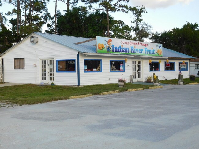
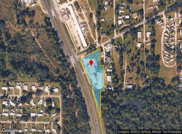
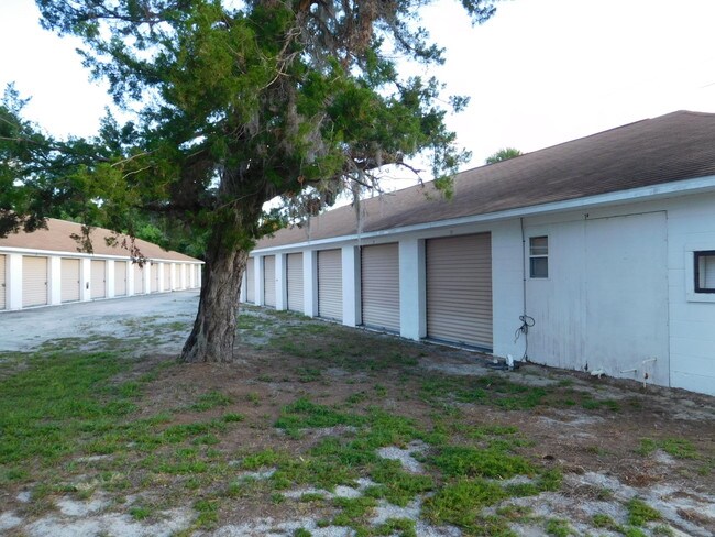
Property Record
321 N Us Highway 1, Oak Hill, FL 32759

NEARBY LISTINGS FOR SALE OR LEASE
-
-
View all Oak Hill listings for sale on LoopNet.com
Property Detail
321 N Us Highway 1
9506-00-00-0130
6-19-35 S 1/2 OF NE 1/4 OF NE 1/4 E OF U S HWY NO 1 & S OF CR & W 50 FT S OF OLD TRAM RD OF NW 1/4 OF NW 1/4 OF 5-19-35 EXC N 200 FT PER OR 4412 PG 0420 PER OR 8059 PG 2895
Warehouse
Volusia
X
Florida
12127C0715J
2.13 AC
2025
SE Volusia County
2026
Deltona/Daytona Beach
083003
Deltona-Daytona Beach-Ormond Beach, FL
14,344 SF
DEMOGRAPHICS near 321 N Us Highway 1
1 Mile
3 Mile
5 Mile
2024 Total Population
1,656
4,651
7,976
2029 Population
1,866
5,233
8,987
Pop Growth 2024-2029
+ 12.68%
+ 12.51%
+ 12.68%
Average Age
51
52
53
2024 Total Households
755
2,160
3,751
HH Growth 2024-2029
+ 12.98%
+ 12.73%
+ 12.90%
Median Household Inc
$50,320
$53,795
$56,853
Avg Household Size
2.20
2.10
2.10
2024 Avg HH Vehicles
2.00
2.00
2.00
Median Home Value
$257,670
$232,604
$227,299
Median Year Built
1992
1992
1992
Nearby Places
Map Layers
Map Styles
 Street
 Aerial
- Restaurants
- Banks
- Shops
- Fitness
- Groceries
PUBLIC TRANSPORTATION
AIRPORT
Daytona Beach International
DRIVE
WALK
Distance
Daytona Beach International
42 min
30.3 mi
Orlando Sanford International
DRIVE
WALK
Distance
Orlando Sanford International
58 min
33.9 mi
Freight Ports
Port Canaveral
DRIVE
WALK
Distance
Port Canaveral
59 min
47.9 mi
SALE & LEASE HISTORY
LISTING DATE
SALE/LEASE

Jul 24, 2019
For Sale
Nearby Properties
Address
Land Use
TOTAL SIZE
Lot Size
Zoning
Address
Land Use
TOTAL SIZE
Lot Size
Zoning
76,446 SF
10.09 AC
11R1
Address
Land Use
TOTAL SIZE
Lot Size
Zoning
24,071 SF
0.63 AC
11R1
Address
Land Use
TOTAL SIZE
Lot Size
Zoning
631 AC
Address
Land Use
TOTAL SIZE
Lot Size
Zoning
582 AC
Address
Land Use
TOTAL SIZE
Lot Size
Zoning
41.90 AC
01B4
Address
Land Use
TOTAL SIZE
Lot Size
Zoning
411 AC
RCW
Address
Land Use
TOTAL SIZE
Lot Size
Zoning
1,102 SF
12.63 AC
B7W
Address
Land Use
TOTAL SIZE
Lot Size
Zoning
5,288 SF
10.45 AC
MH5W
Address
Land Use
TOTAL SIZE
Lot Size
Zoning
4,808 SF
5.75 AC
01B4
Address
Land Use
TOTAL SIZE
Lot Size
Zoning
18,561 SF
2.75 AC
Address
Land Use
TOTAL SIZE
Lot Size
Zoning
Address
Land Use
TOTAL SIZE
Lot Size
Zoning
11,161 SF
1.40 AC
11R3
Address
Land Use
TOTAL SIZE
Lot Size
Zoning
1,436 SF
3.44 AC
Address
Land Use
TOTAL SIZE
Lot Size
Zoning
9,100 SF
1.56 AC
11B3
Address
Land Use
TOTAL SIZE
Lot Size
Zoning
15,240 SF
14.25 AC
MH5
Address
Land Use
TOTAL SIZE
Lot Size
Zoning
3,633 SF
3.81 AC
Address
Land Use
TOTAL SIZE
Lot Size
Zoning
1,016 SF
15.87 AC
PW
Address
Land Use
TOTAL SIZE
Lot Size
Zoning
45,060 SF
2.63 AC
Address
Land Use
TOTAL SIZE
Lot Size
Zoning
11,607 SF
1.41 AC
Address
Land Use
TOTAL SIZE
Lot Size
Zoning
4,361 SF
4.63 AC
R3W
Address
Land Use
TOTAL SIZE
Lot Size
Zoning
10,311 SF
6.99 AC
A3
Address
Land Use
TOTAL SIZE
Lot Size
Zoning
12,284 SF
2.38 AC
01B4
Address
Land Use
TOTAL SIZE
Lot Size
Zoning
2,245 SF
2.53 AC
Address
Land Use
TOTAL SIZE
Lot Size
Zoning
640 AC
CW
Address
Land Use
TOTAL SIZE
Lot Size
Zoning
636 AC
CW
Address
Land Use
TOTAL SIZE
Lot Size
Zoning
6,330 SF
1.43 AC
11B4
Address
Land Use
TOTAL SIZE
Lot Size
Zoning
12,500 SF
2.49 AC
Address
Land Use
TOTAL SIZE
Lot Size
Zoning
5,677 SF
1.70 AC
Address
Land Use
TOTAL SIZE
Lot Size
Zoning
4,554 SF
15.17 AC
MH5W
Address
Land Use
TOTAL SIZE
Lot Size
Zoning
5,124 SF
1.40 AC
11B3
The World's #1 Commercial Real Estate Marketplace
Connect with us
© 2026 CoStar Group
The information above has been obtained from sources believed reliable. While we do not doubt its accuracy we have not verified it and make no guarantee, warranty or representation about it. It is your responsibility to independently confirm its accuracy and completeness. Any projections, opinions, assumptions, or estimates used are for example only and do not represent the current or future performance of the property. The value of this transaction to you depends on tax and other factors which should be evaluated by your tax, financial, and legal advisors. You and your advisors should conduct a careful, independent investigation of the property to determine to your satisfaction the suitability of the property for your needs.