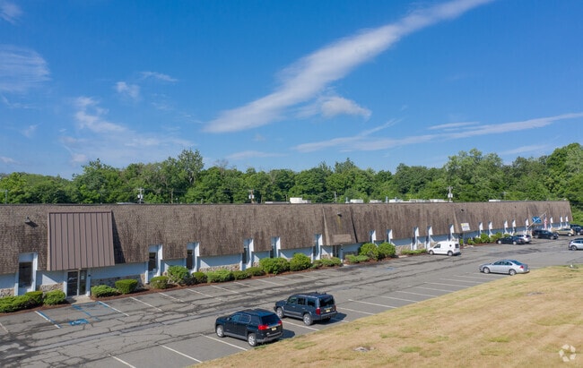
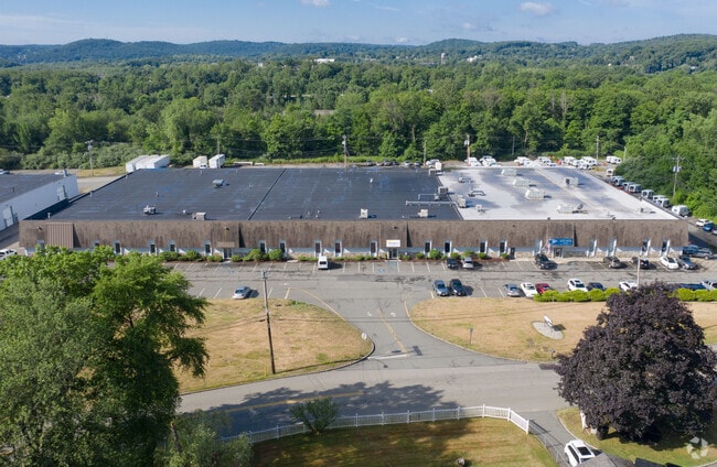
Property Record
321 Richard Mine Rd, Wharton, NJ 07885

Current Lease Availabilities
NEARBY LISTINGS FOR SALE OR LEASE
Property Detail
321 Richard Mine Rd
Newark, NJ-PA
Rockaway
35-11509-0000-00011
Morris
Industrialgeneral
New Jersey
2024
11
2025
6.50 AC
044503
Eastern Morris
80,800 SF
Northern New Jersey
DEMOGRAPHICS near 321 Richard Mine Rd
1 Mile
3 Mile
5 Mile
2024 Total Population
4,355
51,419
111,927
2029 Population
4,438
51,548
112,039
Pop Growth 2024-2029
+ 1.91%
+ 0.25%
+ 0.10%
Average Age
42
41
42
2024 Total Households
1,877
18,396
41,653
HH Growth 2024-2029
+ 1.86%
+ 0.34%
+ 0.10%
Median Household Inc
$110,972
$89,575
$101,873
Avg Household Size
2.30
2.70
2.60
2024 Avg HH Vehicles
2.00
2.00
2.00
Median Home Value
$333,802
$356,934
$381,017
Median Year Built
1978
1966
1967
Nearby Places
Map Layers
Map Styles
 Street
 Aerial
- Restaurants
- Banks
- Shops
- Fitness
- Groceries
PUBLIC TRANSPORTATION
COMMUTER RAIL
Dover (Montclair-Boonton Line - NJ Transit Commuter Rail (NJ Transit), Morris & Essex Morristown Line - NJ Transit Commuter Rail (NJ Transit))
DRIVE
WALK
Distance
Dover (Montclair-Boonton Line - NJ Transit Commuter Rail (NJ Transit), Morris & Essex Morristown Line - NJ Transit Commuter Rail (NJ Transit))
7 min
4.1 mi
Mount Arlington (Montclair-Boonton Line - NJ Transit Commuter Rail (NJ Transit), Morris & Essex Morristown Line - NJ Transit Commuter Rail (NJ Transit))
DRIVE
WALK
Distance
Mount Arlington (Montclair-Boonton Line - NJ Transit Commuter Rail (NJ Transit), Morris & Essex Morristown Line - NJ Transit Commuter Rail (NJ Transit))
8 min
5.1 mi
AIRPORT
Newark Liberty International
DRIVE
WALK
Distance
Newark Liberty International
46 min
33.6 mi
Freight Ports
Maher Terminal
DRIVE
WALK
Distance
Maher Terminal
48 min
34.1 mi
Nearby Properties
Address
Land Use
TOTAL SIZE
Lot Size
Zoning
Address
Land Use
TOTAL SIZE
Lot Size
Zoning
1,023 SF
143.31 AC
OR-3
Address
Land Use
TOTAL SIZE
Lot Size
Zoning
6,271.80 AC
R20A
Address
Land Use
TOTAL SIZE
Lot Size
Zoning
401,303 SF
59.54 AC
R-B
Address
Land Use
TOTAL SIZE
Lot Size
Zoning
64.62 AC
R3
Address
Land Use
TOTAL SIZE
Lot Size
Zoning
5,686 SF
557.09 AC
M
Address
Land Use
TOTAL SIZE
Lot Size
Zoning
30.13 AC
I-3
Address
Land Use
TOTAL SIZE
Lot Size
Zoning
95,368 SF
33.81 AC
RMF8
Address
Land Use
TOTAL SIZE
Lot Size
Zoning
23.66 AC
I1
Address
Land Use
TOTAL SIZE
Lot Size
Zoning
20.05 AC
R-1
Address
Land Use
TOTAL SIZE
Lot Size
Zoning
3.01 AC
Address
Land Use
TOTAL SIZE
Lot Size
Zoning
97,716 SF
60.89 AC
0-2
Address
Land Use
TOTAL SIZE
Lot Size
Zoning
Address
Land Use
TOTAL SIZE
Lot Size
Zoning
156,564 SF
19.66 AC
B-2
Address
Land Use
TOTAL SIZE
Lot Size
Zoning
44,600 SF
18.62 AC
R-B
Address
Land Use
TOTAL SIZE
Lot Size
Zoning
195,773 SF
43.54 AC
R-4
Address
Land Use
TOTAL SIZE
Lot Size
Zoning
18.35 AC
RMF8
Address
Land Use
TOTAL SIZE
Lot Size
Zoning
19,106 SF
19.25 AC
R-B
Address
Land Use
TOTAL SIZE
Lot Size
Zoning
8.08 AC
I-1
Address
Land Use
TOTAL SIZE
Lot Size
Zoning
153,609 SF
17.54 AC
R-B
Address
Land Use
TOTAL SIZE
Lot Size
Zoning
13.53 AC
R10
Address
Land Use
TOTAL SIZE
Lot Size
Zoning
261,582 SF
18.38 AC
R-B
Address
Land Use
TOTAL SIZE
Lot Size
Zoning
25.95 AC
I-1
Address
Land Use
TOTAL SIZE
Lot Size
Zoning
38.15 AC
R-1
Address
Land Use
TOTAL SIZE
Lot Size
Zoning
30.90 AC
I-2
Address
Land Use
TOTAL SIZE
Lot Size
Zoning
68,016 SF
6.53 AC
R-B
Address
Land Use
TOTAL SIZE
Lot Size
Zoning
149,815 SF
31.70 AC
Address
Land Use
TOTAL SIZE
Lot Size
Zoning
97,350 SF
8.28 AC
R-B
Address
Land Use
TOTAL SIZE
Lot Size
Zoning
7.77 AC
RMF
Address
Land Use
TOTAL SIZE
Lot Size
Zoning
87,853 SF
12.42 AC
R-B
Address
Land Use
TOTAL SIZE
Lot Size
Zoning
181,056 SF
12.88 AC
R-B
The World's #1 Commercial Real Estate Marketplace
Connect with us
© 2025 CoStar Group
The information above has been obtained from sources believed reliable. While we do not doubt its accuracy we have not verified it and make no guarantee, warranty or representation about it. It is your responsibility to independently confirm its accuracy and completeness. Any projections, opinions, assumptions, or estimates used are for example only and do not represent the current or future performance of the property. The value of this transaction to you depends on tax and other factors which should be evaluated by your tax, financial, and legal advisors. You and your advisors should conduct a careful, independent investigation of the property to determine to your satisfaction the suitability of the property for your needs.