Property Record
321 S Main St, Malvern, AR 72104
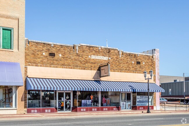

Property Detail
321 S Main St
Malvern, AR
NORTH 30 FT OF LOT 5
700-01217-000
Hot Spring
Storebuilding
Arkansas
B and X Area of moderate flood hazard, usually the area between the limits of the 100-year and 500-year floods.
4,5
2025
0.22 AC
2025
Arkansas South Area
020400
Other Market Areas
7,532 SF
NEARBY LISTINGS FOR SALE OR LEASE
-
-
View all Malvern listings for sale on LoopNet.com
DEMOGRAPHICS near 321 S Main St
1 mile
3 mile
5 mile
2025 Total Population
5,068
11,327
15,069
2030 Population
5,061
11,282
15,025
Pop Growth 2025-2030
(0.14%)
(0.40%)
(0.29%)
Average Age
41
41
42
2025 Total Households
2,114
4,422
5,554
HH Growth 2025-2030
0.00%
(0.43%)
(0.41%)
Median Household Inc
$40,596
$44,360
$46,092
Avg Household Size
2.30
2.30
2.40
2025 Avg HH Vehicles
2.00
2.00
2.00
Median Home Value
$96,690
$111,394
$123,861
Median Year Built
1967
1970
1972
Nearby Places
Map Layers
Map Styles
 Street
 Aerial
Layers
 Traffic
 Biking
Places
Listings with unknown addresses are not visible on the map
- Restaurants
- Banks
- Shops
- Fitness
- Groceries
PUBLIC TRANSPORTATION
COMMUTER RAIL
Drive
Walk
Distance
1 min
6 min
0.3 mi
AIRPORT
Bill and Hillary Clinton Ntl/Adams Field
Drive
Walk
Distance
Bill and Hillary Clinton Ntl/Adams Field
53 min
46.5 mi
SALE & LEASE HISTORY
LISTING DATE
SALE/LEASE

Sep 23, 2016
For Sale
May 10, 2019
For Sale
Apr 18, 2017
For Sale
Nearby Properties
Address
Land Use
TOTAL SIZE
Lot Size
Zoning
Address
Land Use
TOTAL SIZE
Lot Size
Zoning
159,013 SF
14.48 AC
Address
Land Use
TOTAL SIZE
Lot Size
Zoning
39,312 SF
2.19 AC
Address
Land Use
TOTAL SIZE
Lot Size
Zoning
18,360 SF
2.62 AC
Address
Land Use
TOTAL SIZE
Lot Size
Zoning
129,005 SF
64.27 AC
Address
Land Use
TOTAL SIZE
Lot Size
Zoning
14,865 SF
5 AC
Address
Land Use
TOTAL SIZE
Lot Size
Zoning
44,701 SF
5.76 AC
Address
Land Use
TOTAL SIZE
Lot Size
Zoning
58,460 SF
9.03 AC
Address
Land Use
TOTAL SIZE
Lot Size
Zoning
66,368 SF
4.90 AC
Address
Land Use
TOTAL SIZE
Lot Size
Zoning
142,495 SF
7.56 AC
Address
Land Use
TOTAL SIZE
Lot Size
Zoning
38,652 SF
3.67 AC
Address
Land Use
TOTAL SIZE
Lot Size
Zoning
75,041 SF
7.27 AC
Address
Land Use
TOTAL SIZE
Lot Size
Zoning
36,026 SF
6.95 AC
Address
Land Use
TOTAL SIZE
Lot Size
Zoning
277,832 SF
12.29 AC
Address
Land Use
TOTAL SIZE
Lot Size
Zoning
25,290 SF
1.09 AC
Address
Land Use
TOTAL SIZE
Lot Size
Zoning
70,346 SF
8.29 AC
Address
Land Use
TOTAL SIZE
Lot Size
Zoning
25,804 SF
4 AC
Address
Land Use
TOTAL SIZE
Lot Size
Zoning
93,536 SF
32.17 AC
Address
Land Use
TOTAL SIZE
Lot Size
Zoning
27,642 SF
2.58 AC
Address
Land Use
TOTAL SIZE
Lot Size
Zoning
16,748 SF
3.54 AC
Address
Land Use
TOTAL SIZE
Lot Size
Zoning
7,396 SF
4 AC
Address
Land Use
TOTAL SIZE
Lot Size
Zoning
130,460 SF
17.31 AC
Address
Land Use
TOTAL SIZE
Lot Size
Zoning
14,476 SF
Address
Land Use
TOTAL SIZE
Lot Size
Zoning
17,750 SF
1.75 AC
Address
Land Use
TOTAL SIZE
Lot Size
Zoning
54,138 SF
1.49 AC
Address
Land Use
TOTAL SIZE
Lot Size
Zoning
65,668 SF
13.84 AC
Address
Land Use
TOTAL SIZE
Lot Size
Zoning
19,732 SF
1.43 AC
Address
Land Use
TOTAL SIZE
Lot Size
Zoning
14,466 SF
1.37 AC
Address
Land Use
TOTAL SIZE
Lot Size
Zoning
31,958 SF
2.60 AC
Address
Land Use
TOTAL SIZE
Lot Size
Zoning
6,768 SF
0.87 AC
Address
Land Use
TOTAL SIZE
Lot Size
Zoning
102,784 SF
24.45 AC
The World's #1 Commercial Real Estate Marketplace
Connect with us
© 2026 CoStar Group
The information above has been obtained from sources believed reliable. While we do not doubt its accuracy we have not verified it and make no guarantee, warranty or representation about it. It is your responsibility to independently confirm its accuracy and completeness. Any projections, opinions, assumptions, or estimates used are for example only and do not represent the current or future performance of the property. The value of this transaction to you depends on tax and other factors which should be evaluated by your tax, financial, and legal advisors. You and your advisors should conduct a careful, independent investigation of the property to determine to your satisfaction the suitability of the property for your needs.