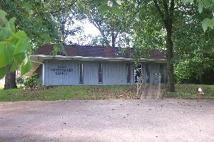
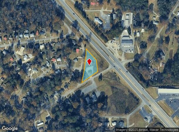
Property Record
321 W Glade Rd, Anniston, AL 36206
NEARBY LISTINGS FOR SALE OR LEASE
Property Detail
321 W Glade Rd
Anniston-Oxford-Jacksonville, AL
Anniston Homestead
18-04-19-4-009-001.000
SEC 19 TSP 15S R 8E ANNISTON HOMESTEAD & FRUITGROWERS ASSOC MAP PT LT 1938 BEG NE COR TAYLOR AVE & GLADE RD NLY ALG E LINE TA
Vacantlandnec
Calhoun
X
Alabama
01015C0304E
1938
2025
0.93 AC
2025
Gadsden/Anniston Area
001600
Other Market Areas
2,802 SF
DEMOGRAPHICS near 321 W Glade Rd
1 Mile
3 Mile
5 Mile
2024 Total Population
4,071
19,752
37,612
2029 Population
4,019
19,715
37,436
Pop Growth 2024-2029
(1.28%)
(0.19%)
(0.47%)
Average Age
40
41
41
2024 Total Households
1,672
8,345
15,594
HH Growth 2024-2029
(1.38%)
(0.19%)
(0.42%)
Median Household Inc
$37,607
$34,177
$39,239
Avg Household Size
2.30
2.20
2.30
2024 Avg HH Vehicles
2.00
2.00
2.00
Median Home Value
$72,047
$82,019
$98,344
Median Year Built
1973
1971
1972
Nearby Places
Map Layers
Map Styles
 Street
 Aerial
- Restaurants
- Banks
- Shops
- Fitness
- Groceries
PUBLIC TRANSPORTATION
COMMUTER RAIL
DRIVE
WALK
Distance
9 min
4.3 mi
Nearby Properties
Address
Land Use
TOTAL SIZE
Lot Size
Zoning
Address
Land Use
TOTAL SIZE
Lot Size
Zoning
4,520 SF
8.20 AC
Address
Land Use
TOTAL SIZE
Lot Size
Zoning
18.55 AC
Address
Land Use
TOTAL SIZE
Lot Size
Zoning
16,541 SF
19.44 AC
Address
Land Use
TOTAL SIZE
Lot Size
Zoning
138,119 SF
13.55 AC
Address
Land Use
TOTAL SIZE
Lot Size
Zoning
203,573 SF
17.16 AC
Address
Land Use
TOTAL SIZE
Lot Size
Zoning
42,158 SF
5.20 AC
Address
Land Use
TOTAL SIZE
Lot Size
Zoning
71,060 SF
2.20 AC
Address
Land Use
TOTAL SIZE
Lot Size
Zoning
103,550 SF
9.15 AC
Address
Land Use
TOTAL SIZE
Lot Size
Zoning
127,717 SF
10 AC
Address
Land Use
TOTAL SIZE
Lot Size
Zoning
Address
Land Use
TOTAL SIZE
Lot Size
Zoning
Address
Land Use
TOTAL SIZE
Lot Size
Zoning
9,034 SF
4.70 AC
Address
Land Use
TOTAL SIZE
Lot Size
Zoning
40,520 SF
4.01 AC
Address
Land Use
TOTAL SIZE
Lot Size
Zoning
51,145 SF
2.49 AC
Address
Land Use
TOTAL SIZE
Lot Size
Zoning
25,325 SF
2.29 AC
Address
Land Use
TOTAL SIZE
Lot Size
Zoning
5,780 SF
62.60 AC
Address
Land Use
TOTAL SIZE
Lot Size
Zoning
65,545 SF
0.80 AC
Address
Land Use
TOTAL SIZE
Lot Size
Zoning
27,338 SF
3.60 AC
Address
Land Use
TOTAL SIZE
Lot Size
Zoning
35,580 SF
3.48 AC
Address
Land Use
TOTAL SIZE
Lot Size
Zoning
48,263 SF
4.05 AC
Address
Land Use
TOTAL SIZE
Lot Size
Zoning
121,812 SF
15.50 AC
Address
Land Use
TOTAL SIZE
Lot Size
Zoning
15,884 SF
0.46 AC
Address
Land Use
TOTAL SIZE
Lot Size
Zoning
7,924 SF
9.50 AC
Address
Land Use
TOTAL SIZE
Lot Size
Zoning
61,526 SF
5.64 AC
Address
Land Use
TOTAL SIZE
Lot Size
Zoning
6,676 SF
54 AC
Address
Land Use
TOTAL SIZE
Lot Size
Zoning
4,736 SF
9 AC
Address
Land Use
TOTAL SIZE
Lot Size
Zoning
Address
Land Use
TOTAL SIZE
Lot Size
Zoning
12,868 SF
2.40 AC
Address
Land Use
TOTAL SIZE
Lot Size
Zoning
4,004 SF
11.64 AC
Address
Land Use
TOTAL SIZE
Lot Size
Zoning
1,068 SF
7.63 AC
The World's #1 Commercial Real Estate Marketplace
Connect with us
© 2025 CoStar Group
The information above has been obtained from sources believed reliable. While we do not doubt its accuracy we have not verified it and make no guarantee, warranty or representation about it. It is your responsibility to independently confirm its accuracy and completeness. Any projections, opinions, assumptions, or estimates used are for example only and do not represent the current or future performance of the property. The value of this transaction to you depends on tax and other factors which should be evaluated by your tax, financial, and legal advisors. You and your advisors should conduct a careful, independent investigation of the property to determine to your satisfaction the suitability of the property for your needs.