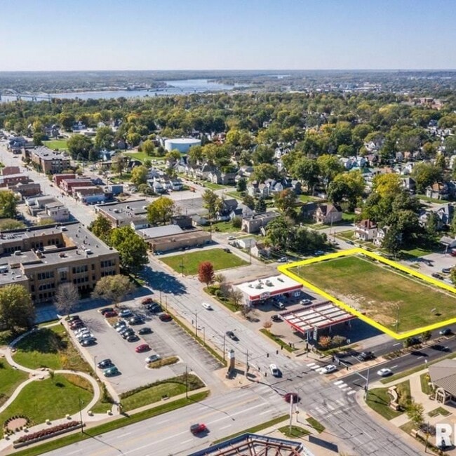
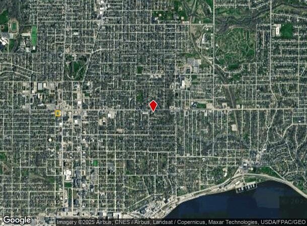
Property Record
321 W Locust St, Davenport, IA 52803
NEARBY LISTINGS FOR SALE OR LEASE
Property Detail
321 W Locust St
Davenport-Moline-Rock Island, IA-IL
Mcintosh's 2Nd Add
G0006-51
MCINTOSH'S 2ND ADD LOT: 006 BLOCK: 011 MCINTOSH'S 2ND ADD BLK 11 LOTS 4, 5, & 6 EXC ROW TO CITY 5-13-65
Commercialacreage
Scott
X
Iowa
19163C0370H
4-6
2025
0.73 AC
2025
Greater Davenport
011400
Davenport/Moline/Rock Island
DEMOGRAPHICS near 321 W Locust St
1 Mile
3 Mile
5 Mile
2024 Total Population
18,162
86,942
175,605
2029 Population
18,140
86,605
173,832
Pop Growth 2024-2029
(0.12%)
(0.39%)
(1.01%)
Average Age
36
39
40
2024 Total Households
7,041
36,509
73,487
HH Growth 2024-2029
+ 0.03%
(0.36%)
(1.03%)
Median Household Inc
$46,451
$52,278
$56,105
Avg Household Size
2.20
2.20
2.30
2024 Avg HH Vehicles
2.00
2.00
2.00
Median Home Value
$123,059
$142,152
$149,126
Median Year Built
1946
1956
1960
Nearby Places
Map Layers
Map Styles
 Street
 Aerial
- Restaurants
- Banks
- Shops
- Fitness
- Groceries
PUBLIC TRANSPORTATION
AIRPORT
Quad Cities International
DRIVE
WALK
Distance
Quad Cities International
23 min
12.0 mi
Freight Ports
Port Milwaukee
DRIVE
WALK
Distance
Port Milwaukee
243 min
213.9 mi
SALE & LEASE HISTORY
LISTING DATE
SALE/LEASE

Mar 06, 2023
For Sale
Mar 06, 2023
For Lease
Nearby Properties
Address
Land Use
TOTAL SIZE
Lot Size
Zoning
Address
Land Use
TOTAL SIZE
Lot Size
Zoning
7,934 SF
8.41 AC
Address
Land Use
TOTAL SIZE
Lot Size
Zoning
3,516 SF
26.74 AC
Address
Land Use
TOTAL SIZE
Lot Size
Zoning
157,587 SF
33.92 AC
Address
Land Use
TOTAL SIZE
Lot Size
Zoning
197,194 SF
5.14 AC
Address
Land Use
TOTAL SIZE
Lot Size
Zoning
253,608 SF
9.29 AC
Address
Land Use
TOTAL SIZE
Lot Size
Zoning
3,500 SF
1.54 AC
Address
Land Use
TOTAL SIZE
Lot Size
Zoning
27,225 SF
40.34 AC
Address
Land Use
TOTAL SIZE
Lot Size
Zoning
27,306 SF
50.57 AC
Address
Land Use
TOTAL SIZE
Lot Size
Zoning
190,832 SF
3.88 AC
Address
Land Use
TOTAL SIZE
Lot Size
Zoning
63,359 SF
12.01 AC
Address
Land Use
TOTAL SIZE
Lot Size
Zoning
472,569 SF
47.24 AC
Address
Land Use
TOTAL SIZE
Lot Size
Zoning
123,823 SF
6.46 AC
Address
Land Use
TOTAL SIZE
Lot Size
Zoning
61,623 SF
2.18 AC
Address
Land Use
TOTAL SIZE
Lot Size
Zoning
76,853 SF
0.56 AC
Address
Land Use
TOTAL SIZE
Lot Size
Zoning
4,944 SF
17.91 AC
Address
Land Use
TOTAL SIZE
Lot Size
Zoning
25,176 SF
13.85 AC
Address
Land Use
TOTAL SIZE
Lot Size
Zoning
26,472 SF
17.67 AC
Address
Land Use
TOTAL SIZE
Lot Size
Zoning
77,187 SF
0.88 AC
Address
Land Use
TOTAL SIZE
Lot Size
Zoning
76,808 SF
1.94 AC
Address
Land Use
TOTAL SIZE
Lot Size
Zoning
27,312 SF
15.04 AC
Address
Land Use
TOTAL SIZE
Lot Size
Zoning
70,098 SF
9.72 AC
Address
Land Use
TOTAL SIZE
Lot Size
Zoning
8,000 SF
4.59 AC
Address
Land Use
TOTAL SIZE
Lot Size
Zoning
104,415 SF
5.89 AC
Address
Land Use
TOTAL SIZE
Lot Size
Zoning
9,658 SF
8.07 AC
Address
Land Use
TOTAL SIZE
Lot Size
Zoning
153,329 SF
2.35 AC
Address
Land Use
TOTAL SIZE
Lot Size
Zoning
96,529 SF
3.52 AC
Address
Land Use
TOTAL SIZE
Lot Size
Zoning
4,800 SF
18.86 AC
Address
Land Use
TOTAL SIZE
Lot Size
Zoning
72,554 SF
0.38 AC
Address
Land Use
TOTAL SIZE
Lot Size
Zoning
65,958 SF
15.04 AC
Address
Land Use
TOTAL SIZE
Lot Size
Zoning
4,958 SF
15.49 AC
The World's #1 Commercial Real Estate Marketplace
Connect with us
© 2025 CoStar Group
The information above has been obtained from sources believed reliable. While we do not doubt its accuracy we have not verified it and make no guarantee, warranty or representation about it. It is your responsibility to independently confirm its accuracy and completeness. Any projections, opinions, assumptions, or estimates used are for example only and do not represent the current or future performance of the property. The value of this transaction to you depends on tax and other factors which should be evaluated by your tax, financial, and legal advisors. You and your advisors should conduct a careful, independent investigation of the property to determine to your satisfaction the suitability of the property for your needs.