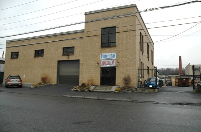
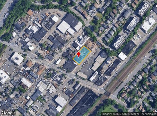
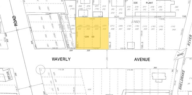
Property Record
321 Waverly Ave, Mamaroneck, NY 10543
NEARBY LISTINGS FOR SALE OR LEASE
Property Detail
321 Waverly Ave
3203-008-000-00024-000-0155-1
Waverly Subdivision
Warehouse
Westchester
AE
New York
36119C0353F
1
2025
0.23 AC
2024
Southeast
007300
Westchester/So Connecticut
6,633 SF
New York-Jersey City-White Plains, NY-NJ
DEMOGRAPHICS near 321 Waverly Ave
1 Mile
3 Mile
5 Mile
2024 Total Population
18,001
85,069
267,660
2029 Population
17,503
83,160
262,789
Pop Growth 2024-2029
(2.77%)
(2.24%)
(1.82%)
Average Age
41
41
41
2024 Total Households
6,695
29,782
95,999
HH Growth 2024-2029
(2.87%)
(2.34%)
(1.83%)
Median Household Inc
$134,589
$173,148
$137,255
Avg Household Size
2.60
2.80
2.70
2024 Avg HH Vehicles
2.00
2.00
2.00
Median Home Value
$774,970
$892,282
$787,468
Median Year Built
1953
1953
1952
Nearby Places
- Restaurants
- Banks
- Shops
- Fitness
- Groceries
PUBLIC TRANSPORTATION
TRANSIT/SUBWAY
Mamaroneck Station (New Haven Line - Metro-North Commuter Railroad Company (Metro-North))
DRIVE
WALK
Distance
Mamaroneck Station (New Haven Line - Metro-North Commuter Railroad Company (Metro-North))
2 min
9 min
0.4 mi
COMMUTER RAIL
Mamaroneck Station (New Haven Line - Metro-North Commuter Railroad Company (Metro-North))
DRIVE
WALK
Distance
Mamaroneck Station (New Haven Line - Metro-North Commuter Railroad Company (Metro-North))
2 min
9 min
0.4 mi
Larchmont Station (New Haven Line - Metro-North Commuter Railroad Company (Metro-North))
DRIVE
WALK
Distance
Larchmont Station (New Haven Line - Metro-North Commuter Railroad Company (Metro-North))
5 min
1.8 mi
AIRPORT
Westchester County
DRIVE
WALK
Distance
Westchester County
21 min
12.1 mi
LaGuardia
DRIVE
WALK
Distance
LaGuardia
34 min
18.5 mi
John F Kennedy International
DRIVE
WALK
Distance
John F Kennedy International
40 min
26.1 mi
Freight Ports
NY - Red Hook Container Terminal
DRIVE
WALK
Distance
NY - Red Hook Container Terminal
48 min
29.0 mi
Nearby Properties
Address
Land Use
TOTAL SIZE
Lot Size
Zoning
Address
Land Use
TOTAL SIZE
Lot Size
Zoning
413,946 SF
20.27 AC
Address
Land Use
TOTAL SIZE
Lot Size
Zoning
Address
Land Use
TOTAL SIZE
Lot Size
Zoning
Address
Land Use
TOTAL SIZE
Lot Size
Zoning
Address
Land Use
TOTAL SIZE
Lot Size
Zoning
125,010 SF
4.02 AC
Address
Land Use
TOTAL SIZE
Lot Size
Zoning
21.33 AC
Address
Land Use
TOTAL SIZE
Lot Size
Zoning
118,723 SF
3.45 AC
Address
Land Use
TOTAL SIZE
Lot Size
Zoning
82,895 SF
23.03 AC
A2
Address
Land Use
TOTAL SIZE
Lot Size
Zoning
188.31 AC
Address
Land Use
TOTAL SIZE
Lot Size
Zoning
67.51 AC
Address
Land Use
TOTAL SIZE
Lot Size
Zoning
1,056 SF
42.50 AC
PB
Address
Land Use
TOTAL SIZE
Lot Size
Zoning
5COMMUND
Address
Land Use
TOTAL SIZE
Lot Size
Zoning
5.57 AC
AA1
Address
Land Use
TOTAL SIZE
Lot Size
Zoning
48,499 SF
8.52 AC
A2/A3
Address
Land Use
TOTAL SIZE
Lot Size
Zoning
61,606 SF
19.99 AC
A4/A3
Address
Land Use
TOTAL SIZE
Lot Size
Zoning
11,951 SF
24.88 AC
Address
Land Use
TOTAL SIZE
Lot Size
Zoning
132,505 SF
5.53 AC
R6
Address
Land Use
TOTAL SIZE
Lot Size
Zoning
6.31 AC
R-5 SFR
Address
Land Use
TOTAL SIZE
Lot Size
Zoning
37,187 SF
2.62 AC
Address
Land Use
TOTAL SIZE
Lot Size
Zoning
Address
Land Use
TOTAL SIZE
Lot Size
Zoning
34,454 SF
216.47 AC
Address
Land Use
TOTAL SIZE
Lot Size
Zoning
99,502 SF
11.97 AC
Address
Land Use
TOTAL SIZE
Lot Size
Zoning
74,147 SF
2.76 AC
Address
Land Use
TOTAL SIZE
Lot Size
Zoning
48,240 SF
3.89 AC
Address
Land Use
TOTAL SIZE
Lot Size
Zoning
64,966 SF
4.92 AC
R20
Address
Land Use
TOTAL SIZE
Lot Size
Zoning
68,022 SF
4.31 AC
Address
Land Use
TOTAL SIZE
Lot Size
Zoning
76,258 SF
4.22 AC
R7.5
Address
Land Use
TOTAL SIZE
Lot Size
Zoning
92,960 SF
11.39 AC
Address
Land Use
TOTAL SIZE
Lot Size
Zoning
62,664 SF
3.50 AC
Address
Land Use
TOTAL SIZE
Lot Size
Zoning
93,226 SF
0.82 AC
RM2
The World's #1 Commercial Real Estate Marketplace
Connect with us
© 2025 CoStar Group
The information above has been obtained from sources believed reliable. While we do not doubt its accuracy we have not verified it and make no guarantee, warranty or representation about it. It is your responsibility to independently confirm its accuracy and completeness. Any projections, opinions, assumptions, or estimates used are for example only and do not represent the current or future performance of the property. The value of this transaction to you depends on tax and other factors which should be evaluated by your tax, financial, and legal advisors. You and your advisors should conduct a careful, independent investigation of the property to determine to your satisfaction the suitability of the property for your needs.