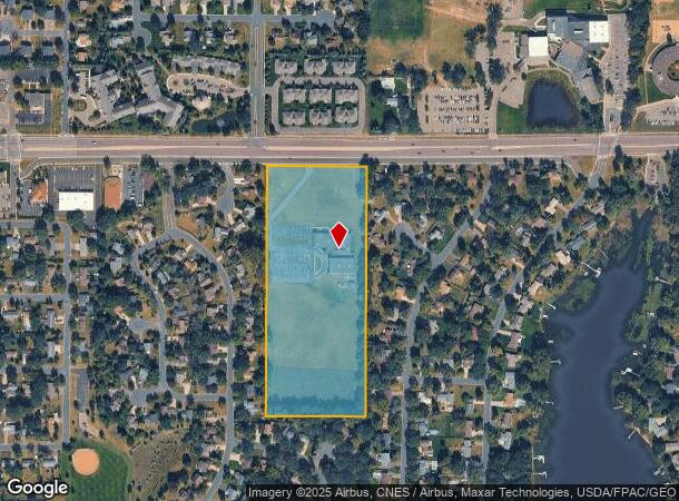
Property Record
3210 Bunker Lake Blvd Nw, Andover, MN 55304

NEARBY LISTINGS FOR SALE OR LEASE
-
-
View all Andover listings for sale on LoopNet.com
Property Detail
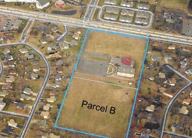
3210 Bunker Lake Blvd Nw
32-32-24-41-0002
THE E 495 FT, AS MEAS ALG N & S LINE, OF NE1/4 OF SE1/4 OF SEC 32 TWP 32 RGE 24, EX RD, SUBJ TO EASE OF REC
Taxexempt
Anoka
X
Minnesota
27053C0100F
13.97 AC
2025
Anoka County Outlying
2025
Minneapolis/St Paul
050208
Minneapolis-St. Paul-Bloomington, MN-WI
27,691 SF
DEMOGRAPHICS near 3210 Bunker Lake Blvd Nw
1 Mile
3 Mile
5 Mile
2024 Total Population
8,074
59,712
147,892
2029 Population
8,316
61,757
151,890
Pop Growth 2024-2029
+ 3.00%
+ 3.42%
+ 2.70%
Average Age
41
40
40
2024 Total Households
3,072
22,537
54,687
HH Growth 2024-2029
+ 3.06%
+ 3.51%
+ 2.74%
Median Household Inc
$95,904
$89,622
$92,450
Avg Household Size
2.60
2.60
2.60
2024 Avg HH Vehicles
2.00
2.00
2.00
Median Home Value
$293,145
$294,185
$296,984
Median Year Built
1986
1985
1986
Nearby Places
Map Layers
Map Styles
 Street
 Aerial
- Restaurants
- Banks
- Shops
- Fitness
- Groceries
PUBLIC TRANSPORTATION
COMMUTER RAIL
Anoka Station (Northstar Corridor - Northstar Commuter Rail)
DRIVE
WALK
Distance
Anoka Station (Northstar Corridor - Northstar Commuter Rail)
9 min
3.2 mi
Coon Rapids-Riverdale Station (Northstar Corridor - Northstar Commuter Rail)
DRIVE
WALK
Distance
Coon Rapids-Riverdale Station (Northstar Corridor - Northstar Commuter Rail)
9 min
3.3 mi
AIRPORT
Minneapolis-St Paul International/Wold-Chamberlain
DRIVE
WALK
Distance
Minneapolis-St Paul International/Wold-Chamberlain
49 min
33.2 mi
Nearby Properties
Address
Land Use
TOTAL SIZE
Lot Size
Zoning
Address
Land Use
TOTAL SIZE
Lot Size
Zoning
517,619 SF
3.85 AC
Address
Land Use
TOTAL SIZE
Lot Size
Zoning
468,099 SF
5.73 AC
MSMU
Address
Land Use
TOTAL SIZE
Lot Size
Zoning
412,914 SF
40 AC
Address
Land Use
TOTAL SIZE
Lot Size
Zoning
2,400 SF
72.45 AC
Address
Land Use
TOTAL SIZE
Lot Size
Zoning
5,110 SF
38.62 AC
Address
Land Use
TOTAL SIZE
Lot Size
Zoning
Address
Land Use
TOTAL SIZE
Lot Size
Zoning
122,816 SF
27.84 AC
Address
Land Use
TOTAL SIZE
Lot Size
Zoning
Address
Land Use
TOTAL SIZE
Lot Size
Zoning
363,449 SF
82.99 AC
R-1
Address
Land Use
TOTAL SIZE
Lot Size
Zoning
225,748 SF
Address
Land Use
TOTAL SIZE
Lot Size
Zoning
129,060 SF
10.21 AC
Address
Land Use
TOTAL SIZE
Lot Size
Zoning
447,671 SF
78.33 AC
Address
Land Use
TOTAL SIZE
Lot Size
Zoning
133,906 SF
34.37 AC
Address
Land Use
TOTAL SIZE
Lot Size
Zoning
343,297 SF
25.42 AC
M-1
Address
Land Use
TOTAL SIZE
Lot Size
Zoning
159,335 SF
13.64 AC
Address
Land Use
TOTAL SIZE
Lot Size
Zoning
7,888 SF
40 AC
Address
Land Use
TOTAL SIZE
Lot Size
Zoning
168,887 SF
7.01 AC
Address
Land Use
TOTAL SIZE
Lot Size
Zoning
148 SF
39.49 AC
Address
Land Use
TOTAL SIZE
Lot Size
Zoning
164,472 SF
10.95 AC
Address
Land Use
TOTAL SIZE
Lot Size
Zoning
114,281 SF
3.19 AC
PRD-4
Address
Land Use
TOTAL SIZE
Lot Size
Zoning
436,117 SF
17.75 AC
M-1
Address
Land Use
TOTAL SIZE
Lot Size
Zoning
118,208 SF
Address
Land Use
TOTAL SIZE
Lot Size
Zoning
155,849 SF
0.83 AC
Address
Land Use
TOTAL SIZE
Lot Size
Zoning
811,860 SF
Address
Land Use
TOTAL SIZE
Lot Size
Zoning
160,668 SF
14.87 AC
Address
Land Use
TOTAL SIZE
Lot Size
Zoning
60,588 SF
4.56 AC
Address
Land Use
TOTAL SIZE
Lot Size
Zoning
89,466 SF
5.76 AC
Address
Land Use
TOTAL SIZE
Lot Size
Zoning
195,228 SF
14.77 AC
Address
Land Use
TOTAL SIZE
Lot Size
Zoning
172,335 SF
13.41 AC
Address
Land Use
TOTAL SIZE
Lot Size
Zoning
The World's #1 Commercial Real Estate Marketplace
Connect with us
© 2026 CoStar Group
The information above has been obtained from sources believed reliable. While we do not doubt its accuracy we have not verified it and make no guarantee, warranty or representation about it. It is your responsibility to independently confirm its accuracy and completeness. Any projections, opinions, assumptions, or estimates used are for example only and do not represent the current or future performance of the property. The value of this transaction to you depends on tax and other factors which should be evaluated by your tax, financial, and legal advisors. You and your advisors should conduct a careful, independent investigation of the property to determine to your satisfaction the suitability of the property for your needs.