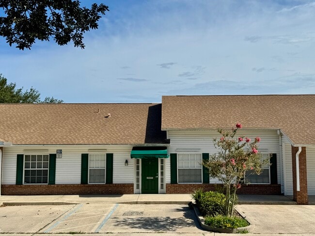
Property Record
3210 N Wickham Rd, Melbourne, FL 32935


NEARBY LISTINGS FOR SALE OR LEASE
Property Detail
3210 N Wickham Rd
Palm Bay-Melbourne-Titusville, FL
Trumbull Office Condo
27-36-01-79-00000.0-0002.00
TRUMBULL OFFICE CONDO UNIT 1 AS DESC IN ORB 4119 PG 273 AND ALL AMENDMENTS THERETO
Officecondo
Brevard
X
Florida
12009C0516G
1
2024
0.20 AC
2025
Brevard County
064102
Orlando
1,814 SF
DEMOGRAPHICS near 3210 N Wickham Rd
1 Mile
3 Mile
5 Mile
2024 Total Population
8,517
55,864
99,287
2029 Population
9,307
60,581
108,321
Pop Growth 2024-2029
+ 9.28%
+ 8.44%
+ 9.10%
Average Age
44
44
45
2024 Total Households
3,980
23,993
42,378
HH Growth 2024-2029
+ 8.79%
+ 8.18%
+ 8.85%
Median Household Inc
$70,468
$70,797
$76,238
Avg Household Size
2.10
2.30
2.30
2024 Avg HH Vehicles
2.00
2.00
2.00
Median Home Value
$297,128
$274,545
$301,483
Median Year Built
1989
1987
1985
Nearby Places
Map Layers
Map Styles
 Street
 Aerial
- Restaurants
- Banks
- Shops
- Fitness
- Groceries
PUBLIC TRANSPORTATION
AIRPORT
Melbourne Orlando International
DRIVE
WALK
Distance
Melbourne Orlando International
16 min
7.2 mi
Freight Ports
Port Canaveral
DRIVE
WALK
Distance
Port Canaveral
40 min
21.7 mi
SALE & LEASE HISTORY
LISTING DATE
SALE/LEASE

Jun 28, 2025
For Sale
Feb 21, 2020
For Lease
Nearby Properties
Address
Land Use
TOTAL SIZE
Lot Size
Zoning
Address
Land Use
TOTAL SIZE
Lot Size
Zoning
676,548 SF
117.62 AC
I1
Address
Land Use
TOTAL SIZE
Lot Size
Zoning
438,381 SF
25.66 AC
R2
Address
Land Use
TOTAL SIZE
Lot Size
Zoning
363,826 SF
25.61 AC
RA
Address
Land Use
TOTAL SIZE
Lot Size
Zoning
236,982 SF
39.26 AC
EU2
Address
Land Use
TOTAL SIZE
Lot Size
Zoning
360,921 SF
85.76 AC
R2
Address
Land Use
TOTAL SIZE
Lot Size
Zoning
269,111 SF
21.79 AC
PUD
Address
Land Use
TOTAL SIZE
Lot Size
Zoning
328,357 SF
34.11 AC
I1
Address
Land Use
TOTAL SIZE
Lot Size
Zoning
296,436 SF
28.05 AC
Address
Land Use
TOTAL SIZE
Lot Size
Zoning
216,446 SF
14.09 AC
R2
Address
Land Use
TOTAL SIZE
Lot Size
Zoning
222,779 SF
22.58 AC
R2
Address
Land Use
TOTAL SIZE
Lot Size
Zoning
188,237 SF
13.97 AC
R2
Address
Land Use
TOTAL SIZE
Lot Size
Zoning
253,120 SF
16.02 AC
R2
Address
Land Use
TOTAL SIZE
Lot Size
Zoning
198,876 SF
64.32 AC
M1
Address
Land Use
TOTAL SIZE
Lot Size
Zoning
146,527 SF
42.12 AC
M-1
Address
Land Use
TOTAL SIZE
Lot Size
Zoning
188,093 SF
13.11 AC
R2
Address
Land Use
TOTAL SIZE
Lot Size
Zoning
227,172 SF
26.78 AC
BU1
Address
Land Use
TOTAL SIZE
Lot Size
Zoning
131,585 SF
10 AC
R2
Address
Land Use
TOTAL SIZE
Lot Size
Zoning
218,739 SF
11.23 AC
R2
Address
Land Use
TOTAL SIZE
Lot Size
Zoning
200,878 SF
16.41 AC
R2
Address
Land Use
TOTAL SIZE
Lot Size
Zoning
132,340 SF
14.58 AC
R2
Address
Land Use
TOTAL SIZE
Lot Size
Zoning
142,230 SF
13.33 AC
C1
Address
Land Use
TOTAL SIZE
Lot Size
Zoning
102,972 SF
18 AC
R2(6)
Address
Land Use
TOTAL SIZE
Lot Size
Zoning
97,430 SF
51.89 AC
BU1
Address
Land Use
TOTAL SIZE
Lot Size
Zoning
171,773 SF
8.02 AC
R2
Address
Land Use
TOTAL SIZE
Lot Size
Zoning
196,340 SF
20.46 AC
CP
Address
Land Use
TOTAL SIZE
Lot Size
Zoning
184,197 SF
12 AC
R1AAA
Address
Land Use
TOTAL SIZE
Lot Size
Zoning
87,681 SF
11.53 AC
I1
Address
Land Use
TOTAL SIZE
Lot Size
Zoning
147,729 SF
9.32 AC
I1
Address
Land Use
TOTAL SIZE
Lot Size
Zoning
145,250 SF
10.85 AC
CR1A
Address
Land Use
TOTAL SIZE
Lot Size
Zoning
92,119 SF
14.64 AC
I1
The World's #1 Commercial Real Estate Marketplace
Connect with us
© 2025 CoStar Group
The information above has been obtained from sources believed reliable. While we do not doubt its accuracy we have not verified it and make no guarantee, warranty or representation about it. It is your responsibility to independently confirm its accuracy and completeness. Any projections, opinions, assumptions, or estimates used are for example only and do not represent the current or future performance of the property. The value of this transaction to you depends on tax and other factors which should be evaluated by your tax, financial, and legal advisors. You and your advisors should conduct a careful, independent investigation of the property to determine to your satisfaction the suitability of the property for your needs.