Property Record
3214 W Lawrence Ave, Chicago, IL 60625
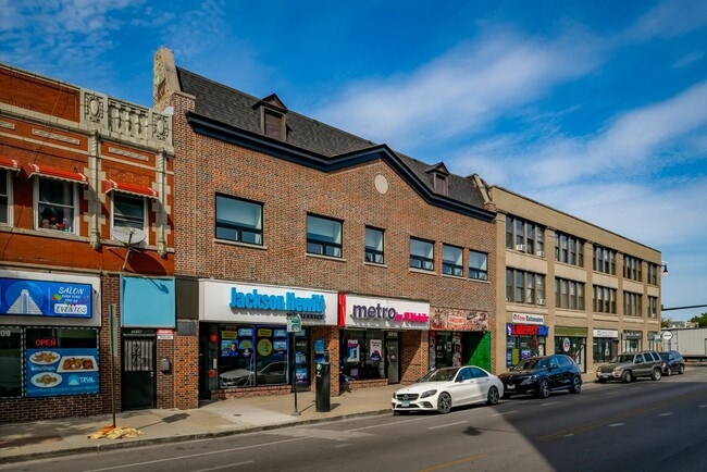
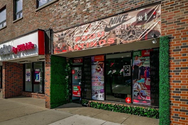
This Property Is For Sale
NEARBY LISTINGS FOR SALE OR LEASE
Property Detail
3214 W Lawrence Ave
Chicago-Naperville-Elgin, IL-IN-WI
Thomassons Fourth Ravenswood
13-11-431-021-0000
(THOMASSONS)(FOURTH)(RAVENSWOOD) ADD IN BLKS 21 & 28 OF JACKSONS SUB OF & IN SW SEC 12 SE SEC 11-40-13
Storebuilding
Cook
X
Illinois
17031C0404J
46,47
2023
0.72 AC
2024
Albany Park
140200
Chicago
14,500 SF
DEMOGRAPHICS near 3214 W Lawrence Ave
1 Mile
3 Mile
5 Mile
2024 Total Population
64,127
447,300
1,058,811
2029 Population
60,943
427,132
1,012,433
Pop Growth 2024-2029
(4.97%)
(4.51%)
(4.38%)
Average Age
37
38
38
2024 Total Households
24,214
188,825
452,166
HH Growth 2024-2029
(5.43%)
(4.74%)
(4.44%)
Median Household Inc
$74,973
$78,200
$79,983
Avg Household Size
2.50
2.30
2.20
2024 Avg HH Vehicles
1.00
1.00
1.00
Median Home Value
$376,952
$406,125
$384,601
Median Year Built
1946
1947
1948
Nearby Places
- Restaurants
- Banks
- Shops
- Fitness
- Groceries
PUBLIC TRANSPORTATION
TRANSIT/SUBWAY
Kedzie Station (Brown Line) (Brown Line - Chicago Transit Authority "L" Trains (The "L"))
DRIVE
WALK
Distance
Kedzie Station (Brown Line) (Brown Line - Chicago Transit Authority "L" Trains (The "L"))
1 min
4 min
0.2 mi
Kimball Station (Brown Line - Chicago Transit Authority "L" Trains (The "L"))
DRIVE
WALK
Distance
Kimball Station (Brown Line - Chicago Transit Authority "L" Trains (The "L"))
1 min
5 min
0.3 mi
Francisco Station (Brown Line - Chicago Transit Authority "L" Trains (The "L"))
DRIVE
WALK
Distance
Francisco Station (Brown Line - Chicago Transit Authority "L" Trains (The "L"))
2 min
10 min
0.5 mi
Rockwell Station (Brown Line - Chicago Transit Authority "L" Trains (The "L"))
DRIVE
WALK
Distance
Rockwell Station (Brown Line - Chicago Transit Authority "L" Trains (The "L"))
4 min
18 min
0.9 mi
COMMUTER RAIL
Ravenswood Station (Union Pacific North Line - Northeast Illinois Regional Commuter Railroad (Metra))
DRIVE
WALK
Distance
Ravenswood Station (Union Pacific North Line - Northeast Illinois Regional Commuter Railroad (Metra))
5 min
2.0 mi
Mayfair Station (Milwaukee District North Line - Northeast Illinois Regional Commuter Railroad (Metra))
DRIVE
WALK
Distance
Mayfair Station (Milwaukee District North Line - Northeast Illinois Regional Commuter Railroad (Metra))
6 min
2.8 mi
AIRPORT
Chicago O'Hare International
DRIVE
WALK
Distance
Chicago O'Hare International
41 min
13.9 mi
Chicago Midway International
DRIVE
WALK
Distance
Chicago Midway International
30 min
15.9 mi
Nearby Properties
Address
Land Use
TOTAL SIZE
Lot Size
Zoning
Address
Land Use
TOTAL SIZE
Lot Size
Zoning
Address
Land Use
TOTAL SIZE
Lot Size
Zoning
16.93 AC
POS-1,PD 1
Address
Land Use
TOTAL SIZE
Lot Size
Zoning
1 AC
RS-3
Address
Land Use
TOTAL SIZE
Lot Size
Zoning
305,592 SF
27.35 AC
Address
Land Use
TOTAL SIZE
Lot Size
Zoning
21.56 AC
RS-2
Address
Land Use
TOTAL SIZE
Lot Size
Zoning
PD 184
Address
Land Use
TOTAL SIZE
Lot Size
Zoning
237,832 SF
14.04 AC
PD 418
Address
Land Use
TOTAL SIZE
Lot Size
Zoning
277,195 SF
1.78 AC
PD 1094
Address
Land Use
TOTAL SIZE
Lot Size
Zoning
190,011 SF
5.90 AC
PD 353
Address
Land Use
TOTAL SIZE
Lot Size
Zoning
170,538 SF
0.76 AC
PD 112
Address
Land Use
TOTAL SIZE
Lot Size
Zoning
331,294 SF
13.03 AC
PD 439
Address
Land Use
TOTAL SIZE
Lot Size
Zoning
201,600 SF
1.93 AC
PD 92
Address
Land Use
TOTAL SIZE
Lot Size
Zoning
2.25 AC
PD 612
Address
Land Use
TOTAL SIZE
Lot Size
Zoning
139.71 AC
PD 184
Address
Land Use
TOTAL SIZE
Lot Size
Zoning
140,451 SF
9.48 AC
PD 213
Address
Land Use
TOTAL SIZE
Lot Size
Zoning
15,600 SF
0.77 AC
M1-1
Address
Land Use
TOTAL SIZE
Lot Size
Zoning
226,345 SF
3.71 AC
PD 1203
Address
Land Use
TOTAL SIZE
Lot Size
Zoning
100,900 SF
4.85 AC
PD 1415
Address
Land Use
TOTAL SIZE
Lot Size
Zoning
340,838 SF
31 AC
PD 1411
Address
Land Use
TOTAL SIZE
Lot Size
Zoning
197,785 SF
4.03 AC
PD 943
Address
Land Use
TOTAL SIZE
Lot Size
Zoning
32,200 SF
5.67 AC
B3-5,RM-6.
Address
Land Use
TOTAL SIZE
Lot Size
Zoning
1.57 AC
PD 1052
Address
Land Use
TOTAL SIZE
Lot Size
Zoning
63,700 SF
7.42 AC
PD 796
Address
Land Use
TOTAL SIZE
Lot Size
Zoning
24,400 SF
0.50 AC
B3-2
Address
Land Use
TOTAL SIZE
Lot Size
Zoning
5.48 AC
RT-4,PD 10
Address
Land Use
TOTAL SIZE
Lot Size
Zoning
78,410 SF
4.87 AC
PD 171
Address
Land Use
TOTAL SIZE
Lot Size
Zoning
0.43 AC
RS-2
Address
Land Use
TOTAL SIZE
Lot Size
Zoning
145,031 SF
1.90 AC
PD 372
Address
Land Use
TOTAL SIZE
Lot Size
Zoning
67,588 SF
2.50 AC
PD 415
Address
Land Use
TOTAL SIZE
Lot Size
Zoning
0.23 AC
B3-3
The World's #1 Commercial Real Estate Marketplace
Connect with us
© 2025 CoStar Group
The information above has been obtained from sources believed reliable. While we do not doubt its accuracy we have not verified it and make no guarantee, warranty or representation about it. It is your responsibility to independently confirm its accuracy and completeness. Any projections, opinions, assumptions, or estimates used are for example only and do not represent the current or future performance of the property. The value of this transaction to you depends on tax and other factors which should be evaluated by your tax, financial, and legal advisors. You and your advisors should conduct a careful, independent investigation of the property to determine to your satisfaction the suitability of the property for your needs.