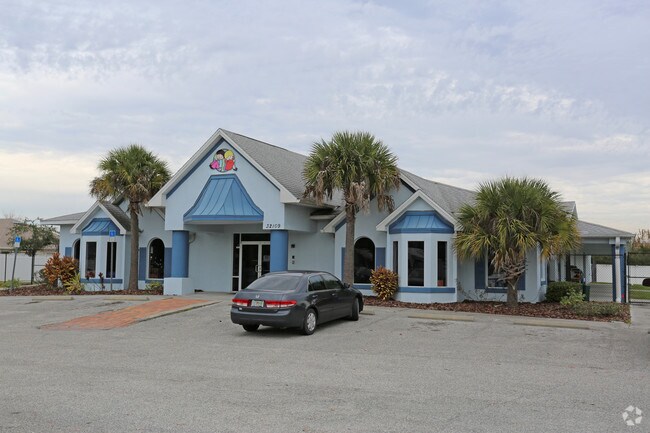
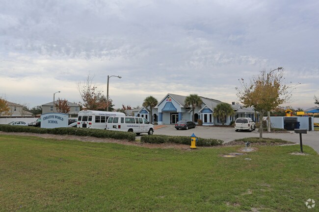
Property Record
32109 State Road 54 Blvd, Wesley Chapel, FL 33543

NEARBY LISTINGS FOR SALE OR LEASE
Property Detail
32109 State Road 54 Blvd
Tampa-St. Petersburg-Clearwater, FL
S.R. 54
14-26-20-0000-00100-0040
COM AT SOUTHERLYMOST COR LOT 13 BLOCK 4 NEW RIVER LAKES VILLAGES B2&D PB 44 PG 105 TH ALG NLY BDY OF 45 FT PERPETUAL UTILITY & ROADWAY ESMT PER OR 4214 PG 634 CURVE RIGHT RAD 5835.58 FT CHD S57 DEG 5844E 42.82 FT TH S57DEG 4607E 271.51 FT TH N32DEG 1
Officebuilding
Pasco
X
Florida
12101C0431F
13
2024
1.06 AC
2025
Pasco County
032105
Tampa/St Petersburg
8,170 SF
DEMOGRAPHICS near 32109 State Road 54 Blvd
1 Mile
3 Mile
5 Mile
2024 Total Population
5,088
42,343
107,279
2029 Population
6,196
52,233
130,711
Pop Growth 2024-2029
+ 21.78%
+ 23.36%
+ 21.84%
Average Age
36
38
40
2024 Total Households
1,648
14,672
38,462
HH Growth 2024-2029
+ 21.84%
+ 23.29%
+ 21.84%
Median Household Inc
$105,159
$90,291
$86,490
Avg Household Size
3.00
2.80
2.70
2024 Avg HH Vehicles
2.00
2.00
2.00
Median Home Value
$293,762
$292,439
$288,763
Median Year Built
2010
2008
2005
Nearby Places
- Restaurants
- Banks
- Shops
- Fitness
- Groceries
PUBLIC TRANSPORTATION
AIRPORT
Tampa International
DRIVE
WALK
Distance
Tampa International
46 min
33.9 mi
Freight Ports
Port of Tampa Bay
DRIVE
WALK
Distance
Port of Tampa Bay
42 min
29.6 mi
Nearby Properties
Address
Land Use
TOTAL SIZE
Lot Size
Zoning
Address
Land Use
TOTAL SIZE
Lot Size
Zoning
398,092 SF
22.48 AC
MPUD
Address
Land Use
TOTAL SIZE
Lot Size
Zoning
277,779 SF
18.93 AC
MPUD
Address
Land Use
TOTAL SIZE
Lot Size
Zoning
253,292 SF
22.26 AC
MPUD
Address
Land Use
TOTAL SIZE
Lot Size
Zoning
309,662 SF
59.03 AC
MF1
Address
Land Use
TOTAL SIZE
Lot Size
Zoning
252,942 SF
13.59 AC
MPUD
Address
Land Use
TOTAL SIZE
Lot Size
Zoning
418,644 SF
105.51 AC
AR
Address
Land Use
TOTAL SIZE
Lot Size
Zoning
287,834 SF
14.40 AC
MPUD
Address
Land Use
TOTAL SIZE
Lot Size
Zoning
241,371 SF
11.48 AC
MPUD
Address
Land Use
TOTAL SIZE
Lot Size
Zoning
50,016 SF
14.04 AC
MPUD
Address
Land Use
TOTAL SIZE
Lot Size
Zoning
142,552 SF
5.69 AC
MPUD
Address
Land Use
TOTAL SIZE
Lot Size
Zoning
109,440 SF
3.28 AC
C2
Address
Land Use
TOTAL SIZE
Lot Size
Zoning
92,475 SF
19.45 AC
MPUD
Address
Land Use
TOTAL SIZE
Lot Size
Zoning
19.81 AC
MPUD
Address
Land Use
TOTAL SIZE
Lot Size
Zoning
6.13 AC
MPUD
Address
Land Use
TOTAL SIZE
Lot Size
Zoning
90,759 SF
4.29 AC
MPUD
Address
Land Use
TOTAL SIZE
Lot Size
Zoning
93,933 SF
3.63 AC
C2
Address
Land Use
TOTAL SIZE
Lot Size
Zoning
90,404 SF
17.90 AC
MPUD
Address
Land Use
TOTAL SIZE
Lot Size
Zoning
129,416 SF
3.87 AC
C2
Address
Land Use
TOTAL SIZE
Lot Size
Zoning
80,584 SF
22.43 AC
MPUD
Address
Land Use
TOTAL SIZE
Lot Size
Zoning
14.84 AC
MPUD
Address
Land Use
TOTAL SIZE
Lot Size
Zoning
93,395 SF
6.71 AC
MPUD
Address
Land Use
TOTAL SIZE
Lot Size
Zoning
11,189 SF
34.32 AC
C2
Address
Land Use
TOTAL SIZE
Lot Size
Zoning
48,241 SF
7.67 AC
MPUD
Address
Land Use
TOTAL SIZE
Lot Size
Zoning
82,605 SF
37.03 AC
AR
Address
Land Use
TOTAL SIZE
Lot Size
Zoning
69,405 SF
2.15 AC
MPUD
Address
Land Use
TOTAL SIZE
Lot Size
Zoning
31,857 SF
3.46 AC
MPUD
Address
Land Use
TOTAL SIZE
Lot Size
Zoning
104,720 SF
13.22 AC
C2
Address
Land Use
TOTAL SIZE
Lot Size
Zoning
64,769 SF
11.78 AC
C2
Address
Land Use
TOTAL SIZE
Lot Size
Zoning
209.20 AC
MPUD
Address
Land Use
TOTAL SIZE
Lot Size
Zoning
25.69 AC
MPUD
The World's #1 Commercial Real Estate Marketplace
Connect with us
© 2025 CoStar Group
The information above has been obtained from sources believed reliable. While we do not doubt its accuracy we have not verified it and make no guarantee, warranty or representation about it. It is your responsibility to independently confirm its accuracy and completeness. Any projections, opinions, assumptions, or estimates used are for example only and do not represent the current or future performance of the property. The value of this transaction to you depends on tax and other factors which should be evaluated by your tax, financial, and legal advisors. You and your advisors should conduct a careful, independent investigation of the property to determine to your satisfaction the suitability of the property for your needs.