Property Record
3211 Branch Ave, Temple Hills, MD 20748
NEARBY LISTINGS FOR SALE OR LEASE
Property Detail
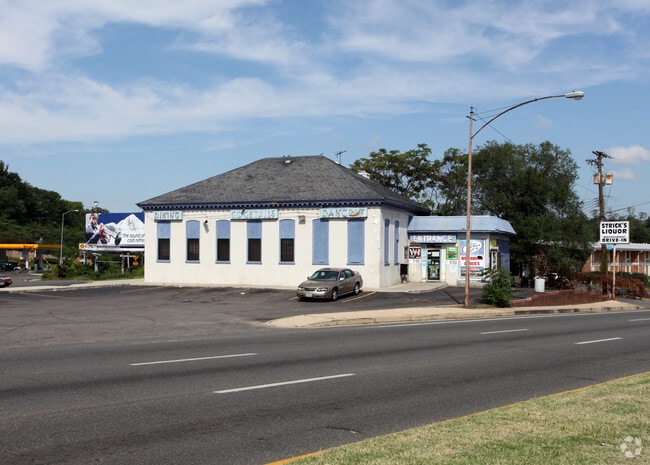
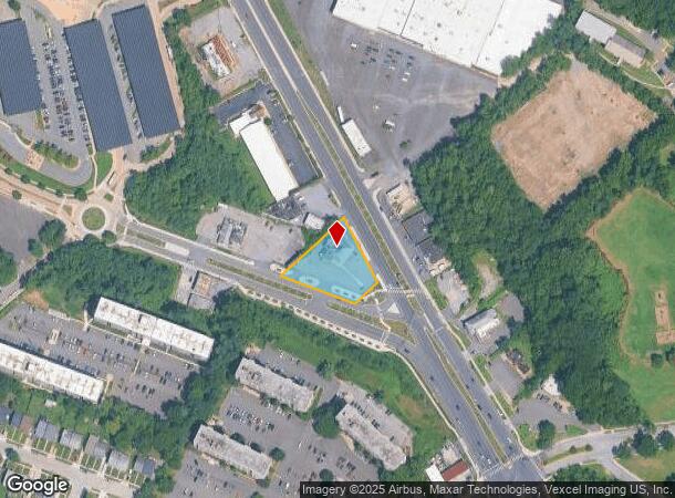
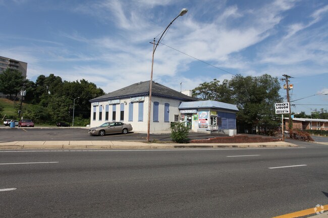
3211 Branch Ave
06-0630392
Stricks Restaurant
Restaurantbuilding
SILVER HILL AC PT PAR 80
X
Prince George's
24033C0230E
Maryland
2024
0.51 AC
2025
Branch Avenue Corridor
801809
Washington, DC
3,646 SF
Washington-Arlington-Alexandria, DC-VA-MD-WV
DEMOGRAPHICS near 3211 Branch Ave
1 Mile
3 Mile
5 Mile
2024 Total Population
22,420
199,579
462,203
2029 Population
21,403
188,123
437,272
Pop Growth 2024-2029
(4.54%)
(5.74%)
(5.39%)
Average Age
39
38
38
2024 Total Households
9,832
81,726
198,109
HH Growth 2024-2029
(4.84%)
(6.28%)
(5.97%)
Median Household Inc
$60,790
$57,623
$72,967
Avg Household Size
2.20
2.30
2.20
2024 Avg HH Vehicles
1.00
1.00
1.00
Median Home Value
$294,249
$337,533
$373,616
Median Year Built
1962
1964
1967
Nearby Places
Map Layers
Map Styles
 Street
 Aerial
- Restaurants
- Banks
- Shops
- Fitness
- Groceries
PUBLIC TRANSPORTATION
TRANSIT/SUBWAY
Naylor Road (Green Line - Washington Metropolitan Area Transit Authority Metrorail (Metrorail))
DRIVE
WALK
Distance
Naylor Road (Green Line - Washington Metropolitan Area Transit Authority Metrorail (Metrorail))
2 min
5 min
0.3 mi
COMMUTER RAIL
L'Enfant (Fredericksburg Line - Virginia Railway Express, Manassas Line - Virginia Railway Express)
DRIVE
WALK
Distance
L'Enfant (Fredericksburg Line - Virginia Railway Express, Manassas Line - Virginia Railway Express)
11 min
6.3 mi
DRIVE
WALK
Distance
11 min
6.3 mi
AIRPORT
Ronald Reagan Washington Ntl
DRIVE
WALK
Distance
Ronald Reagan Washington Ntl
20 min
10.3 mi
Baltimore/Washington International Thurgood Marshall
DRIVE
WALK
Distance
Baltimore/Washington International Thurgood Marshall
50 min
32.4 mi
Washington Dulles International
DRIVE
WALK
Distance
Washington Dulles International
56 min
34.6 mi
Freight Ports
Port of Baltimore
DRIVE
WALK
Distance
Port of Baltimore
59 min
38.7 mi
Nearby Properties
Address
Land Use
TOTAL SIZE
Lot Size
Zoning
Address
Land Use
TOTAL SIZE
Lot Size
Zoning
169.85 AC
R-2;RA-1;U
Address
Land Use
TOTAL SIZE
Lot Size
Zoning
3,231,903 SF
173.70 AC
UNZONED
Address
Land Use
TOTAL SIZE
Lot Size
Zoning
2,131,229 SF
144.34 AC
AG
Address
Land Use
TOTAL SIZE
Lot Size
Zoning
450,000 SF
37.35 AC
UNZONED
Address
Land Use
TOTAL SIZE
Lot Size
Zoning
30,000 SF
819.17 AC
PDR-1;RA-1
Address
Land Use
TOTAL SIZE
Lot Size
Zoning
356,000 SF
16.42 AC
RA-1;RF-1
Address
Land Use
TOTAL SIZE
Lot Size
Zoning
36.52 AC
HE-2;HE-3;
Address
Land Use
TOTAL SIZE
Lot Size
Zoning
963,250 SF
10.71 AC
RTOLE
Address
Land Use
TOTAL SIZE
Lot Size
Zoning
234,260 SF
1.39 AC
MU-4
Address
Land Use
TOTAL SIZE
Lot Size
Zoning
417 SF
7.66 AC
RTOLE
Address
Land Use
TOTAL SIZE
Lot Size
Zoning
192,440 SF
7.67 AC
R-2;RA-1
Address
Land Use
TOTAL SIZE
Lot Size
Zoning
274,244 SF
6.24 AC
RA-1
Address
Land Use
TOTAL SIZE
Lot Size
Zoning
264,723 SF
MU-4
Address
Land Use
TOTAL SIZE
Lot Size
Zoning
107,130 SF
2.98 AC
R-2;RA-1
Address
Land Use
TOTAL SIZE
Lot Size
Zoning
308,000 SF
1.76 AC
HE-1;HE-2
Address
Land Use
TOTAL SIZE
Lot Size
Zoning
262,236 SF
15.26 AC
MU-8B
Address
Land Use
TOTAL SIZE
Lot Size
Zoning
68,992 SF
3.19 AC
STE-12;STE
Address
Land Use
TOTAL SIZE
Lot Size
Zoning
352,146 SF
6.32 AC
RA-2
Address
Land Use
TOTAL SIZE
Lot Size
Zoning
2.08 AC
SEFC-3
Address
Land Use
TOTAL SIZE
Lot Size
Zoning
6 AC
RTOLE
Address
Land Use
TOTAL SIZE
Lot Size
Zoning
62,797 SF
0.55 AC
R2
Address
Land Use
TOTAL SIZE
Lot Size
Zoning
348,525 SF
11 AC
STE-11
Address
Land Use
TOTAL SIZE
Lot Size
Zoning
473,030 SF
3.08 AC
RA-1
Address
Land Use
TOTAL SIZE
Lot Size
Zoning
92,511 SF
1.48 AC
RA-1
Address
Land Use
TOTAL SIZE
Lot Size
Zoning
45.36 AC
MU-1;RA-1
Address
Land Use
TOTAL SIZE
Lot Size
Zoning
207,338 SF
3.07 AC
PDR-4
Address
Land Use
TOTAL SIZE
Lot Size
Zoning
232,095 SF
8.25 AC
RA-2
Address
Land Use
TOTAL SIZE
Lot Size
Zoning
99,540 SF
3.81 AC
HE-1;HE-2
Address
Land Use
TOTAL SIZE
Lot Size
Zoning
701 SF
29.42 AC
RMF20
Address
Land Use
TOTAL SIZE
Lot Size
Zoning
450 SF
21.14 AC
RMF20
The World's #1 Commercial Real Estate Marketplace
Connect with us
© 2025 CoStar Group
The information above has been obtained from sources believed reliable. While we do not doubt its accuracy we have not verified it and make no guarantee, warranty or representation about it. It is your responsibility to independently confirm its accuracy and completeness. Any projections, opinions, assumptions, or estimates used are for example only and do not represent the current or future performance of the property. The value of this transaction to you depends on tax and other factors which should be evaluated by your tax, financial, and legal advisors. You and your advisors should conduct a careful, independent investigation of the property to determine to your satisfaction the suitability of the property for your needs.