Property Record
3211 Martin Luther King Jr Way S, Seattle, WA 98144

NEARBY LISTINGS FOR SALE OR LEASE
Property Detail
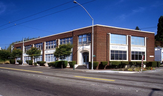
3211 Martin Luther King Jr Way S
Seattle-Tacoma-Bellevue, WA
Sunnyvale Add
811610-0015
SUNNYVALE ADD 3 THRU 6 LESS ST & 11 THRU 14 & POR VAC ST ADJ BLK 1 & LOTS 1 THRU 8 & POR VAC ST ADJ BLK 2 SD ADD LESS POR COND TO C.P.S.R.T.A. (SOUND TRANSIT) ACCORDING TO KING COUNTY S.C.C. NO 03-2-34354-4 SEA - 10/24/2003
Storebuilding
King
X
Washington
53033C0635G
1-8
2025
1.52 AC
2024
S Seattle
010001
Seattle/Puget Sound
20,250 SF
DEMOGRAPHICS near 3211 Martin Luther King Jr Way S
1 Mile
3 Mile
5 Mile
2024 Total Population
24,944
157,090
429,618
2029 Population
25,432
160,638
437,301
Pop Growth 2024-2029
+ 1.96%
+ 2.26%
+ 1.79%
Average Age
40
39
39
2024 Total Households
9,726
70,801
209,376
HH Growth 2024-2029
+ 1.82%
+ 2.48%
+ 1.89%
Median Household Inc
$107,483
$98,300
$112,303
Avg Household Size
2.40
2.00
1.90
2024 Avg HH Vehicles
2.00
1.00
1.00
Median Home Value
$854,637
$846,597
$878,630
Median Year Built
1966
1981
1984
Nearby Places
Map Layers
Map Styles
 Street
 Aerial
- Restaurants
- Banks
- Shops
- Fitness
- Groceries
PUBLIC TRANSPORTATION
TRANSIT/SUBWAY
Mount Baker (Central Link - Central Puget Sound Regional Transit Authority Rail (Link Light Rail/Sounder))
DRIVE
WALK
Distance
Mount Baker (Central Link - Central Puget Sound Regional Transit Authority Rail (Link Light Rail/Sounder))
3 min
7 min
0.4 mi
Beacon Hill (Central Link - Central Puget Sound Regional Transit Authority Rail (Link Light Rail/Sounder))
DRIVE
WALK
Distance
Beacon Hill (Central Link - Central Puget Sound Regional Transit Authority Rail (Link Light Rail/Sounder))
5 min
20 min
1.0 mi
COMMUTER RAIL
King Street (Seattle) Station (Sounder South Line - Central Puget Sound Regional Transit Authority Rail (Link Light Rail/Sounder))
DRIVE
WALK
Distance
King Street (Seattle) Station (Sounder South Line - Central Puget Sound Regional Transit Authority Rail (Link Light Rail/Sounder))
10 min
3.0 mi
AIRPORT
Seattle-Tacoma International
DRIVE
WALK
Distance
Seattle-Tacoma International
25 min
13.3 mi
Seattle Paine Field International
DRIVE
WALK
Distance
Seattle Paine Field International
42 min
27.6 mi
Nearby Properties
Address
Land Use
TOTAL SIZE
Lot Size
Zoning
Address
Land Use
TOTAL SIZE
Lot Size
Zoning
793,990 SF
30.81 AC
UI U/85
Address
Land Use
TOTAL SIZE
Lot Size
Zoning
992,925 SF
4.28 AC
MIO-240-HR
Address
Land Use
TOTAL SIZE
Lot Size
Zoning
1,526,621 SF
1.36 AC
DOC1 U/450
Address
Land Use
TOTAL SIZE
Lot Size
Zoning
1,137,666 SF
2.07 AC
DOC1 U/450
Address
Land Use
TOTAL SIZE
Lot Size
Zoning
7,930 SF
4.14 AC
MIO-240-HR
Address
Land Use
TOTAL SIZE
Lot Size
Zoning
6,379 SF
127.60 AC
MML U/85
Address
Land Use
TOTAL SIZE
Lot Size
Zoning
1,128,575 SF
1.30 AC
DOC1 U/450
Address
Land Use
TOTAL SIZE
Lot Size
Zoning
30,290 SF
564.80 AC
MML U/85
Address
Land Use
TOTAL SIZE
Lot Size
Zoning
861,221 SF
1.30 AC
DMC 340/29
Address
Land Use
TOTAL SIZE
Lot Size
Zoning
1,011,547 SF
0.35 AC
DOC1 U/450
Address
Land Use
TOTAL SIZE
Lot Size
Zoning
412,000 SF
1.27 AC
DOC1 U/450
Address
Land Use
TOTAL SIZE
Lot Size
Zoning
943,610 SF
1.24 AC
DOC1 U/450
Address
Land Use
TOTAL SIZE
Lot Size
Zoning
540,360 SF
1.31 AC
DMC 340/29
Address
Land Use
TOTAL SIZE
Lot Size
Zoning
8,202 SF
1.30 AC
DOC1 U/450
Address
Land Use
TOTAL SIZE
Lot Size
Zoning
899,120 SF
0.62 AC
DOC1 U/450
Address
Land Use
TOTAL SIZE
Lot Size
Zoning
914,733 SF
1.41 AC
DOC1 U/450
Address
Land Use
TOTAL SIZE
Lot Size
Zoning
845,533 SF
0.98 AC
DOC1 U/450
Address
Land Use
TOTAL SIZE
Lot Size
Zoning
990,000 SF
0.33 AC
DOC1 U/450
Address
Land Use
TOTAL SIZE
Lot Size
Zoning
362,344 SF
0.33 AC
MIO-240-HR
Address
Land Use
TOTAL SIZE
Lot Size
Zoning
726,103 SF
0.17 AC
MIO-240-HR
Address
Land Use
TOTAL SIZE
Lot Size
Zoning
38,770 SF
1.31 AC
DOC1 U/450
Address
Land Use
TOTAL SIZE
Lot Size
Zoning
237,533 SF
8.40 AC
LR3 (M)
Address
Land Use
TOTAL SIZE
Lot Size
Zoning
2,800 SF
210.85 AC
NR1
Address
Land Use
TOTAL SIZE
Lot Size
Zoning
385,274 SF
1.31 AC
DOC1 U/450
Address
Land Use
TOTAL SIZE
Lot Size
Zoning
263,600 SF
5.38 AC
II U/160
Address
Land Use
TOTAL SIZE
Lot Size
Zoning
796,463 SF
0.84 AC
DOC1 U/450
Address
Land Use
TOTAL SIZE
Lot Size
Zoning
425,151 SF
2.25 AC
HR (M)
Address
Land Use
TOTAL SIZE
Lot Size
Zoning
284,100 SF
1.45 AC
DOC1 U/450
The World's #1 Commercial Real Estate Marketplace
Connect with us
© 2025 CoStar Group
The information above has been obtained from sources believed reliable. While we do not doubt its accuracy we have not verified it and make no guarantee, warranty or representation about it. It is your responsibility to independently confirm its accuracy and completeness. Any projections, opinions, assumptions, or estimates used are for example only and do not represent the current or future performance of the property. The value of this transaction to you depends on tax and other factors which should be evaluated by your tax, financial, and legal advisors. You and your advisors should conduct a careful, independent investigation of the property to determine to your satisfaction the suitability of the property for your needs.